It was a memorable moment for me attending State of the map Nigeria 2024 conference as I was opportune to meet and engage with professionals and volunteers from different backgrounds.
All the away from Zaria in Kaduna state, Northwest of Nigeria down to Ile-Ife in Osun state, Southwest of Nigeria for State of the map Nigeria 2024 conference. Since it was a long Journey I had to stop at Lokoja, Kogi state for a day. The following day I continued the journey down to Ile-Ife, Osun state. The venue of the conference was at African Regional Institute for Geospatial Information Science and Technology (AFRIGIST) inside Obafemi Awolowo University, Ile-Ife, Osun state, Nigeria.
It was a good beginning starting the programme with an opening mapping party. The opening mapping party started around 6:39pm with the introduction of attendees. A welcome address was done by Dr. Victor Sunday who welcomed everyone to the opening mapping party. Thereafter, the session was handed over to Mr. Calvin Menttor from Ghana who introduced the attendees to OpenStreetMaps.
The programme started by 9:35am with an opening prayer followed by the singing of the national anthem. The introduction of guests to the high table was done and the opening remarks were given by Prof. Lazarus Mustapha Ojigi. The welcome address and the goodwill message were delivered by Dr. Victor Sunday.
The programme started by 9:15am with an opening prayer followed by the introduction of guests to the high table. Key activities for day 3 1. The lead keynote speaker (Prof. Kamorudeen Folorunso Aleem) made a presentation on Open Geospatial, AI Technologies and Geospatial Data Policies in Nigeria: Implications for SDGs. 2. Keynote speaker Adeola Akinwale: Empowering Communities through Drone-Assisted Mapping: A Pathway to Women - Inclusivity and Sustainable Development 3. Keynote speaker ProfAndrew A. Obafemi: The Availability, Quality and Currency of Maps and its Implications for Achieving SDGs in Nigeria
It was an exciting moment as I had the privilege of holding a workshop session with the participants on Land Use and Land Cover (LULC) change detection, modeling and prediction using QGIS and Modules for Land Use Change Simulations (MOLUSCE). The workshop entailed practical demonstration that included: i. Change detection/identification between two epochs ii. Change detection map production between two epochs iii. Artificial Neural Network (ANN) learning curve training iv. Future LULC prediction and simulation v. Question and answer session Data and video tutorial was provided to participants for them to practice at their convenient time.
i. AFRIGIST: Practical session on Downloading and streaming data from DE Africa sandbox to QGIS ii. Hajar El Ouafi: Mapping with Maproullete iii. Caroline Nickerson: Scistarter
Other activities for the day include; Academic paper presentation on Pavement Condition Analysis by Sterling Umoren and Panel Discussion with views on the theme of the conference and the take home
The conference came to an end with Vote of thanks from Dr. Victor Sunday and closing prayer
The following day many participants started their journey back home. I rested for a day before moving to Abuja and from Abuja back to Zaria my base. It was an amazing conference
FROM ZARIA TO ILE-IFE
All the away from Zaria in Kaduna state, Northwest of Nigeria down to Ile-Ife in Osun state, Southwest of Nigeria for State of the map Nigeria 2024 conference. Since it was a long Journey I had to stop at Lokoja, Kogi state for a day. The following day I continued the journey down to Ile-Ife, Osun state. The venue of the conference was at African Regional Institute for Geospatial Information Science and Technology (AFRIGIST) inside Obafemi Awolowo University, Ile-Ife, Osun state, Nigeria.
THE OPENING MAPPING PARTY
It was a good beginning starting the programme with an opening mapping party. The opening mapping party started around 6:39pm with the introduction of attendees. A welcome address was done by Dr. Victor Sunday who welcomed everyone to the opening mapping party. Thereafter, the session was handed over to Mr. Calvin Menttor from Ghana who introduced the attendees to OpenStreetMaps.
Activities accomplished in mapping party
- OSM account opening
- Downloading and installation of JOSM
- Linking of JOSM with OSM account
- JOSM setup and plugins installation
- Building mapping: Project 657 (Nigeria- Mapping Missing Roads and Buildings in Ilesa) was done
- Uploading of mapped layer to the OSM server The chairperson in person of Dr. Victor Sunday concluded the session by giving the history of OpenStreetMap and how it became global. The mapping party came to an end by 9:45pm
DAY 2 OF THE CONFERENCE
The programme started by 9:35am with an opening prayer followed by the singing of the national anthem. The introduction of guests to the high table was done and the opening remarks were given by Prof. Lazarus Mustapha Ojigi. The welcome address and the goodwill message were delivered by Dr. Victor Sunday.
Key activities for day 2
- The lead keynote speaker (Prof. Lazarus Mustapha Ojigi) made a presentation on Artificial intelligence-Assisted Geospatial mapping and Modelling Techniques for achieving Sustainable Development Goals in Africa.
- TomTom OpenStreetMap program – Community & Partnership delivered by Salim Badum
- The UAVs Geospatial Intelligence, Surveillance and Data Analytics for SDGs in Nigeria: Spatial Matrix Approach and Example by Captain Tobi Sowole
- AFRIGIST lightning on Open Geospatial Data in Africa Prof. Joseph Oloukoi
- Capacity Building in Space Science and Technology: UNARCSSTEE
- Paper presentation
- Citizen Science and Community Engagement towards Achieving SDGs: Perspectives from Scistarter -Unique Mappers Collaboration by Dr Caroline Nickerson
- The Transformative Power of Youth led data collection in improving health care facilities through electricity planning by Anuoluwapo Kuye
- Unlocking Geospatial Insights with Open Source Tools: A QGIS and OSM Tutorial by Ezekiel Ogungbemi The activities for the day came to an end by 6:00pm
Day 3
The programme started by 9:15am with an opening prayer followed by the introduction of guests to the high table. Key activities for day 3 1. The lead keynote speaker (Prof. Kamorudeen Folorunso Aleem) made a presentation on Open Geospatial, AI Technologies and Geospatial Data Policies in Nigeria: Implications for SDGs. 2. Keynote speaker Adeola Akinwale: Empowering Communities through Drone-Assisted Mapping: A Pathway to Women - Inclusivity and Sustainable Development 3. Keynote speaker ProfAndrew A. Obafemi: The Availability, Quality and Currency of Maps and its Implications for Achieving SDGs in Nigeria
WORKSHOP SESSION
It was an exciting moment as I had the privilege of holding a workshop session with the participants on Land Use and Land Cover (LULC) change detection, modeling and prediction using QGIS and Modules for Land Use Change Simulations (MOLUSCE). The workshop entailed practical demonstration that included: i. Change detection/identification between two epochs ii. Change detection map production between two epochs iii. Artificial Neural Network (ANN) learning curve training iv. Future LULC prediction and simulation v. Question and answer session Data and video tutorial was provided to participants for them to practice at their convenient time.
Other workshop session for the day include;
i. AFRIGIST: Practical session on Downloading and streaming data from DE Africa sandbox to QGIS ii. Hajar El Ouafi: Mapping with Maproullete iii. Caroline Nickerson: Scistarter
Other activities for the day include; Academic paper presentation on Pavement Condition Analysis by Sterling Umoren and Panel Discussion with views on the theme of the conference and the take home
The conference came to an end with Vote of thanks from Dr. Victor Sunday and closing prayer
Departure
The following day many participants started their journey back home. I rested for a day before moving to Abuja and from Abuja back to Zaria my base. It was an amazing conference
A while back I had taken a look comparing my local OGL to others in our area that were approved and listed on the wiki. Noting the similarities to existing documents I added our local cities as well per their attribution requirements.
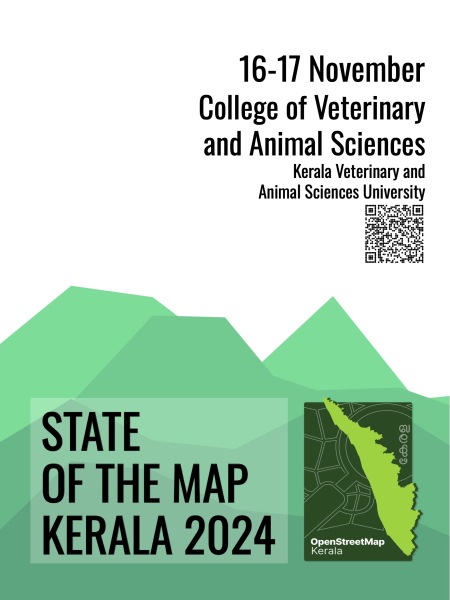
Were thrilled to announce that our OpenStreetMap Kerala Annual Community Meetup 2024 has now been officially branded as State of the Map Kerala 2024! Heartfelt thanks to the OpenStreetMap Foundation for swiftly approving the license—this may be the f…
If you have some expertise the problem of correct rendering of border disputes and some spare time, then your help is welcome. If not, than of course you are welcome too!
Just been out this morning and surveyed Arran Road on foot. Around 40 businesses to add, plus two burger vans (oh, yes). When I was a youngster, the whole place was approx. 10 large factories, now it’s been much extended and the old factories have been subdivided into many small units. Should keep me busy for a while.
OpenStreetMap is a map of the world, created by people like you and free to use under an open license.
Attending the recent hack weekend in Berlin, I got inspired to work on a neat feature in overpass turbo. Honestly speaking, in the past few years, the tool did not the amount of attention from the developers (my) side that it deserves.
the arch of September has its feral grip slapped free from the gators grip of October, I’m holding fast to turkeys and dipping my head in the gravy
Botanical Explorations in Buru Island, Maluku Archipelago
Cashless payments have increased dramatically lately, specially during COVID-19 main years. Still, paying in cash can be crucial as a resilience method (think internet, power, banking system outages).
The State of the Map Nigeria Conference was indeed a unique one. Packed with a lot of excitement. When I said it was fun I really mean it. All the guest speakers both online and in person did very well and I personally learnt a lot from the conference. The conference was held from 8th to 11st of October 2024.
I definitely seem to love this website. Afterall, it allows me to add some facilities thanks to data provided by french government services : electricity substations, monuments, post boxes, various problems, …
For today, the main municipalities I worked on with OsmOse are Paluel, Néville, Cailleville, Angiens, Cany-Barville, etc… . I also fixed merged adresses and shops so that data is associated accordingly. I started to fix issues in the Rouen metropolis as well, however it will take a few days to finish the whole city considering its size.
Little announcement : I plan to set sort of a weekly schedule to the tasks I want to do. This way, each day of the week will be dedicated to one task in particular, and will have a special name ; for example, SamedInspector (for non-french speakers, it means that saturday would be dedicated to OSM Inspector). Also, even though I will have a weekly schedule, I will switch from 1 entry/day to 1 entry/week that will contain everything I’ve done within the last 7 days.
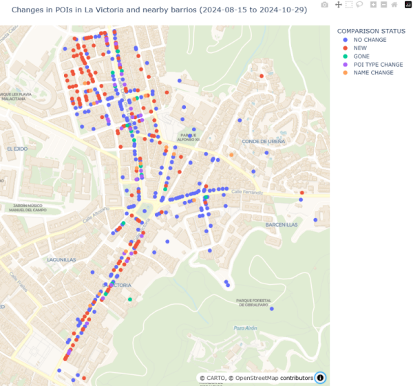
In Part 3 I talked about changes in POI data in a small area over a period of two months. Most of those changes were due to mapping activity, rather than anything that happened in the real world over that period.
…and suddenly, I woke up early in the morning just to realize that I was in Lagos on 8th October. Ask yourself what brought me here? Hehehehe Of course, State of the Map Nigeria Conference 2024.
Mapping the Future: Highlights from the State of the Map Nigeria 2024
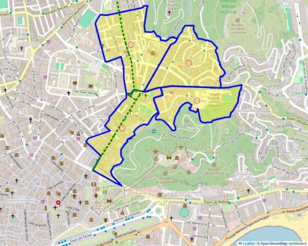
As I mentioned in Parts 1 and 2, over the last couple of months I set out to systematically update Points of Interest in four adjoining barrios in the city of Málaga.
This is the first time I try micromapping in OSM. It took quite a while to learn the appropriate tags for some amenities, but I got there in the end. For a first, I decided to focus on an open area I know very well, which is a square in my hometown.
It seems that I tend to forget to publish my daily diary entry on time ; I’ll do my best to do so, even for light workloads
Yesterday, I rode my bicycle to check on-site issues that I noticed with addresses in Saint-Valery-en-Caux. I managed to fix them all, and to map a few fire hydrants as well.
Yesterday, I rode my bicycle to check on-site issues that I noticed with addresses in Saint-Valery-en-Caux. I managed to fix them all, and to map a few fire hydrants as well.

Day 87 : Fixing addresses & mapping fire hydrants in Saint-Valery-en-Caux
It seems that I tend to forget to publish my daily diary entry on time ; Ill do my best to do so, even for light workloadsOpenStreetMap
I was putting together some facts and stats* on OpenAerialMap and the open drone imagery it hosts and thought it might be interesting / useful for OSM peeps as a key user group
This year the weather has been quite awful in Milan, and Sunday 20th it was raining once again. However, later during the day it was nice and even sunny, so I decided to go for another trip.
Yesterday, I worked on two municipalities : Jumièges and Saint-Valery-en-Caux, the latter being the one in which I live. I used once again the Pifomètre tool to add adresses. However, I don’t think I’ve finished everything in Jumièges, so I’ll have to work on this municipality again today.

Day 86 : Adresses & driveways at Jumièges & Saint-Valery-en-Caux
Yesterday, I worked on two municipalities : Jumièges and Saint-Valery-en-Caux, the latter being the one in which I live. I used once again the Pifomètre tool to add adresses.OpenStreetMap
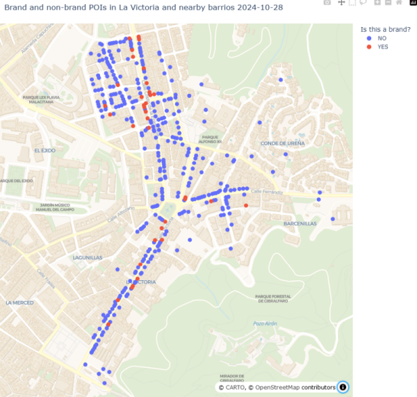
As part of my systematic update of local POIs (see Part 1), I added the brand and brand:wikidata tags wherever I could identify them. Before I started I thought I might find quite a few POIs that I had not previously recognised as brands.
Recently I have been trying to systematically improve OSM data about shops, businesses, and other Points of Interest in a small area of my city.
Dear Diary,
Now I know what your thinking, “what kind of boy has a diary”. Its NOT a diary, remember that reader. Its a INTRICATE PROGRESS LOGGING DEVICE that is mine and mine only! Yeah, i guess you could say its a kind of “Dairy of a Wimpy Kid”, heh! Well thats awkward… Nettspend Out!
Now I know what your thinking, “what kind of boy has a diary”. Its NOT a diary, remember that reader. Its a INTRICATE PROGRESS LOGGING DEVICE that is mine and mine only! Yeah, i guess you could say its a kind of “Dairy of a Wimpy Kid”, heh! Well thats awkward… Nettspend Out!
I finished solving my personal OSMose issues (mainly level 3) and other ones in municipalities around Saint-Valery-en-Caux.
To correctly tag some services, I needed to use Pifomètre for two municipalities.
I also fixed a few issues in OSM Inspector around Saint-Valery-en-Caux and Rouen, although it is pretty difficult to understand what’s wrong sometimes.
Another OSM user rightfully told me that one edit I did on bus lanes in Rouen was wrong in terms of tags, so I managed to correct it.
You may know that the preparations for this year’s OpenStreetMap Kerala Annual Meetup have started. We had a meeting on the 20th to find a suitable venue and date and to brainstorm related matters and form a working group for the same.
I decided to fix, once again, all of the issues attributed to me by OSMose. I managed to fix almost all of them for levels 1 and 2. I’ll probably fix the level 3 ones tomorrow.
Today, I also discovered the OSMose map. I already knew about the website itself, but only on its personal list form. Therefore, I decided to fix almost all the issues in my hometown, Saint-Valery-en-Caux. I briefly also fixed issues in Rouen and Barentin.
I won’t add the links of my changesets anymore, as I’m too lazy to do so (lol).

Day 84 : OSMose issue solving (All personal lvl 1-2, Saint-Valery-en-Caux, Rouen, Barentin)
I decided to fix, once again, all of the issues attributed to me by OSMose. I managed to fix almost all of them for levels 1 and 2. Ill probably fix the level 3 ones tomorrow.OpenStreetMap
Hello everyone, I have come to the conclusion that the daily mapping challenge I started was probably too ambitious considering my daily life (mainly univ), so I have no choice but to downgrade my ambitions unfortunately. I still will make my best to contribute everyday to OSM and to make daily diary entries, however they won’t be all about mapping a random municipality.

About my daily challenge
Hello everyone, I have come to the conclusion that the daily mapping challenge I started was probably too ambitious considering my daily life (mainly univ), so I have no choice but to downgrade my ambitions unfortunately.OpenStreetMap
In addition to OSM, I occasionally take pictures of the areas I visit to upload them on Mapillary.
Today (or rather, yesterday), I worked on Illois. Near this little village, there is the A29 highway and the D 929 road. There arent too many single-family homes, mainly because quite a few buildings are for agricultural purposes.
Recently I’ve noticed that most of the time I spend on OSM goes either to:
Burnout can also lead to a premature transformation into a nagging grump, which I would love to avoid.
Solution: People with the know-how should instead focus more on providing the best documentation and tooling there is possible to the community. Working on removing ambiguities, providing accurate descriptions and thorough examples. Therefore everyone can learn (and later teach) the right approaches. This pro-active approach is more effective than a re-active one, since less time and work goes to waste, the knowledge is propagated more quickly and in a more lasting manner, economics of scale start to kick in and stuff.
Also at the time of writing this entry it is 1 AM CEST where I live so I guess this makes this post #showerthoughts -approved. Thank you for coming to my TED talk.
- Patrolling recent changes and fixing things which, although were already mapped correctly for years (often by myself), now have been altered (probably in good faith though!) by some newbie who „thought” that the current state is somehow wrong
- Fixing things which were already mapped incorrectly for years (often by myself) at a time when the documentation was unclear or the community consensus was different
Burnout can also lead to a premature transformation into a nagging grump, which I would love to avoid.
Solution: People with the know-how should instead focus more on providing the best documentation and tooling there is possible to the community. Working on removing ambiguities, providing accurate descriptions and thorough examples. Therefore everyone can learn (and later teach) the right approaches. This pro-active approach is more effective than a re-active one, since less time and work goes to waste, the knowledge is propagated more quickly and in a more lasting manner, economics of scale start to kick in and stuff.
Also at the time of writing this entry it is 1 AM CEST where I live so I guess this makes this post #showerthoughts -approved. Thank you for coming to my TED talk.

(Clickbait title) Experienced OSM Mappers should NOT map OSM. Here's why.
Recently Ive noticed that most of the time I spend on OSM goes either to:OpenStreetMap
Its time for another OpenStreetMap-NG development update! This week brings exciting new features and improvements that bring us closer to the projects first public release.
Parks on the Air (POTA) information tags can be added to areas. Its an improvement over the POTA map application as it shows the entire park area rather than a point.
For example, the Victoria Harbour Migratory Bird Sanctuary (CA-4248)
https://pota.
For example, the Victoria Harbour Migratory Bird Sanctuary (CA-4248)
https://pota.
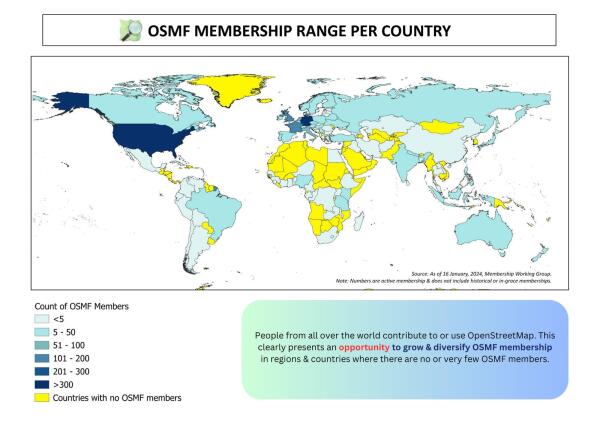
Key highlights: We are happy to share the accomplishments of the 2024 OSMF Membership Campaign: 1) ~ 392 sign up’s from March, most of them were through the Active Contributor Membership Program; 2) there are now members in 16 new countries!; 3) Four…
Well it has been a while. As the result, Im 3 cities late. Fortunately, one week of holidays is coming, so I will have quite a lot of time to catch up.
Embark on a thrilling Chitwan jungle safari and immerse yourself in the vibrant ecosystem of Nepals Terai region. Heres a guide to help you plan your adventure:
One of Nepals most beautiful trekking routes is the Gokyo Trek in the Everest region, which offers tranquil glacial lakes, serene pathways, and amazing vistas of Mount Everest.
Balaji Kirpa Travels provides quick and efficient taxi services in Amritsar. Whether you need a taxi in Amritsar for local travels, a car hire for city tours, or a one-way taxi service, we have you handled.
https://princetontx.gov/DocumentCenter/View/3004/Princeton-Tax-Increment-Reinvestment-Zones-TIRZ_Whitewing-Trails-Phase-2 has information about the Phase 3

Whitewing Trails Phase 3
https://princetontx.gov/DocumentCenter/View/3004/Princeton-Tax-Increment-Reinvestment-Zones-TIRZ_Whitewing-Trails-Phase-2 has information about the Phase 3OpenStreetMap
A few days ago, I started my mapping project for Jāņupe. The main objectives of this project are to add all the missing houses in the area, re-tag the existing ways and some nodes, and retrace the residential and allotment zones.
Revamp and modernize your applications with our comprehensive Application Enhancement Services. From re-engineering legacy systems to integrating modern technologies, we ensure your IT applications operate at peak efficiency.
