There are a number of ongoing discussions about the geocoder on osm.org (Nominatim) in the forum at the moment. These include spelling tolerance, how it might work with data that does not exist in OSM yet and what it actually returns.
If there’s one thing people who know me will say, it’s that I’m a proud Lokeraar through and through. The history of Lokeren, and the way the city keeps changing, has always fascinated me.
It all started in 2019 when I began editing Lokeren’s Wikipedia page. I wanted it to be more than just a dry article—I wanted it to reflect the city’s character with accurate and engaging information. After two years of expanding and polishing, I felt I had done my part there, and I started looking for other ways to put Lokeren on the map.
That’s when I discovered OpenStreetMap in 2021. My first edit was just a tiny stream in Lokeren. But from that small start, it turned into a real passion. Before long, I was mapping everything: trees, bike paths, parking lots, even new buildings as they appeared.
Now, four years later, I can proudly say the mission has been a success so far. But it doesn’t stop here—Lokeren keeps growing, and so does my map. And honestly, that’s the best part: there’s always something new to add, and always another story to tell about my hometown.
Best Smoke shop Near Me
## Best Smoke shop Richmond Texas TX
When we started Smoke Heaven, we saw a need for a different kind of shop. The world of vapes, CBD, and other wellness products was changing fast, and we wanted to create a place where customers could feel confident about their purchases.
That’s why we’ve made it our mission to do the homework for you. We keep up with the latest industry regulations, from the evolving FDA standards for vapes to the new products made possible by the 2018 Farm Bill. This means you can browse our shelves knowing that everything we carry is from a trusted, reputable source.
At Smoke Heaven, you’re not just buying a product—you’re getting a commitment to quality and safety. We’re here to be your go-to source for all your smoking and wellness needs, with a team ready to help you every step of the way.
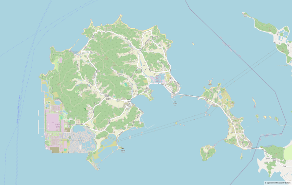
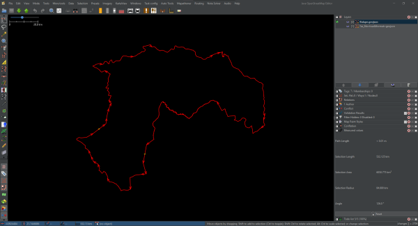
This is the story of how I mapped the islands off the west coast of the Korean Peninsula. The story began on July 24th (two months ago).
Background
In 2023, New Brunswick (Canada) underwent a province-wide restructuring of their municipal boundaries. This consisted of 77 Incorporated Municipalities and 12 Unincorporated Rural Districts. Between 2023 and 2025, only a small handful of these boundaries were actually imported into OSM. Thus, I took it upon myself to begin what was my largest project ever, a full import of the updated boundaries across the province.
I saw it fit to write up a post summarizing the work that was done, along with some of the rationales for certain tagging methods used in this project, in order to maintain consistency both now and into the future. It should be noted that this was not an automated import, every kilometer of boundary was manually reviewed. The data used was from GeoNB, under the Open Government License – New Brunswick.
Pre-Import Phase/Admin Level Restructuring
When I started this project, New Brunswick’s existing boundary data was a complete mess, some larger cities had admin_level=6 boundaries, while other incorporated municipalities were tagged admin_level=8, and parishes were sharing admin_level=6, leading to overlaps. For instance, Saint-François Parish and Haut-Madawaska were both tagged admin_level=6, despite them occupying the same geographical area.
To fix this problem, I decided to shift all Parish boundaries to admin_level=8, and assign admin_level=6 to all municipal boundaries. The new admin level hierarchy is logical because Parishes are not incorporated government entities and have no modern-day purpose. Furthermore, it more closely resembles data in other provinces in Canada (such as Alberta, Quebec, and Nova Scotia), which prioritize admin_level=6 for municipal districts. Both the New Brunswick wiki as well as the Canada admin level wiki pages were updated to reflect these changes.
Below are some examples of the admin_level tagging schema before and after my updates:
Example 1 [Before]:
- admin_level=4 = New Brunswick
- admin_level=5 = Madawaska County
- admin_level=6 = Saint-François Parish
- admin_level=6 = Haut-Madawaska (Municipality)
Example 1 [After]:
- admin_level=4 = New Brunswick
- admin_level=5 = Madawaska County
- admin_level=6 = Haut-Madawaska (Municipality)
- admin_level=8 = Saint-François Parish
Example 2 [Before]:
- admin_level=4 = New Brunswick
- admin_level=5 = Queens County
- admin_level=6 = Gagetown Parish
- admin_level=8 = Village of Gagetown (Municipality)
Example 2 [After]:
- admin_level=4 = New Brunswick
- admin_level=5 = Queens County
- admin_level=6 = Village of Arcadia (Municipality)
- admin_level=8 = Gagetown Parish
Import Workflow
The import process consisted of importing the shapefile data directly from GeoNB, One municipality at a time, and downloading all data within a few metres of the new boundary. This revealed any pre-existing boundaries (County, Parish, and Village boundaries). Any areas where the new municipal boundary was directly overlapped with existing boundaries, it was split and joined to them. As such, boundary members may be part of county, parish, and municipal boundary relations (or any combination of those) simultaneously. After each new Municipality was imported, I removed any old village boundaries & relations which no longer have legal bearing.
While importing the data, I also fixed many instances of pre-existing data quality issues, particularly with overlapping parish boundaries. In some cases, I noted up to 3 different boundaries all overlapping together. After meticulous work across the province, virtually all of these issues have been resolved.
Keeping Boundary Members Neutral
Another issue that came up during my work was the tagging of individual boundary members (the actual ways that are members of the boundary relations). Most of the time, these labels only referred to one side of the region they were splitting. For example, boundary members surrounding Sackville Parish were all labelled “Sackville Parish”, despite the adjacent parishes (eg. Dorchester Parish) sharing the same member.
Mapping best practice would be to label them as “Sackville Parish – Dorchester Parish” to indicate that the boundary seperates two different regions, however in many cases these boundary members were simultaneously part of County and Municipal level boundaries, making this tagging overly complex.
As a result, I decided that it would be easiest to simply leave the boundary members untagged altogether, as their membership within the boundary relations already provides all relevant data. The only exception I made was to First Nation Reserves. Furthermore, leaving these boundary members untagged makes future modifications far easier, as the only things that need to be changed are the boundary relations themselves.
Admin Levels on Coastal Islands
Something peculiar I discovered during my work was certain coastal islands having been tagged with admin_level=6, admin_level=8, and admin_level=9. It’s unclear to me why exactly these boundaries were added to begin with, because these random islands have no administrative structure that would lend itself to requiring an admin level. In my opinion, this is superfluous data that should be removed, however for the short-term, I changed all of them to admin_level=9 to maintain consistency, and avoid overlaps with other administrative regions.
Machias Seal Island
Machias Seal Island is disputed territory with the United States. The government of New Brunswick acknowledges this island as being within Grand Manan Parish, Southwest Rural District, Charlotte County. I did add these administrative regions to the Island as per the GeoNB dataset, however I’m not 100% sure if this is mapping best practice with respect to disputed territory on OSM. To me, It would be equally appropriate to include the county and municipality level information from the United States side, but that decision would have to be made by someone other than myself.
Rural Districts
It should be noted that while New Brunswick’s 12 Rural Districts aren’t technically incorporated Municipalities, they occupy the same geographical/administrative tier, and therefore have also been assigned admin_level=6. This could potentially be changed if somebody thought differently, however my rationale on this was based on Alberta’s admin level structure which tags everything admin_level=6 even for those regions which are technically unincorporated (eg. Special Areas, Improvement Districts).
National Parks & Protected Natural Areas
Generally speaking, I left most of these boundaries separated from the municipal boundaries in order to avoid needlessly complicating things.
Federal Constituency Boundaries
Federal Constituency Boundaries were joined to Municipal level boundary members wherever I came across them, however I did not do a detailed review of these province-wide, and some adjustments may still be required.
Bilingual & Wikidata Tags
As part of this project, all Counties, Municipalities, Parishes, and First Nations Reserves were brought into compliance with the bilingual tagging schema (name:en, name:fr, and name= corresponding to the language most used in that particular region). Additionally, Wikidata tags were added to all 152 parishes, and website links added to all municipalities.
Conclusion
Closing the chapter on this 3 month long project is bittersweet, Despite being very tedious at times, it was a great opportunity to improve my mapping skills and get to know New Brunswick in great detail from the top down. If you would like to view the boundaries on Overpass Turbo, you can use the following queries:
To view all Municipalities & Rural Districts:
[out:json][timeout:25];// gather results
nwr["type"="boundary"]["admin_level"="6"]["name:en"]["name:fr"]({{bbox}});
// print results
out geom;
To view all Parishes:
[out:json][timeout:25];// gather results
nwr["type"="boundary"]["admin_level"="8"]["name:en"]["name:fr"]({{bbox}});
// print results
out geom;
Do not hesitate to contact me with questions, comments, or concerns. Cheers :)
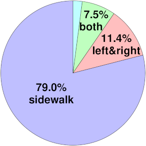
As Im interested in pedestrian infrastructure, I asked myself what percentage of all sidewalks in Germany has already been mapped.
At Healthy Jeena Sikho, we bring affordable and reliable home healthcare solutions right to your doorstep in Gurgaon. Whether you are caring for a loved one recovering at home, managing long-term medical needs, or setting up a temporary ICU at home, we provide the right medical equipment on rent or sale with complete support.
Our Offerings in Gurgaon:
🛏️ Hospital Beds (Manual, Semi-Fowler, Full Fowler, ICU Beds)
🫁 Oxygen Concentrators & Portable Oxygen Machines
💨 BiPAP & CPAP Machines for respiratory care
♿ Wheelchairs (manual & electric)
🏥 Complete ICU Setup at Home
Why Choose Us?
✅ Affordable Rental & Sale Options ✅ Same-Day Delivery Across Gurgaon ✅ Free Demo & Training
Artificial Intelligence OpenAI Maps4 and finance. Things are progressing beautifully.
I am telling it what to do in English, and it’s writing the tags for me and making the edit. I will review everything it does and not do anything with it that I wouldn’t do by hand (but more tediously).
Today was a serene day spent in Thanjavur, and staying at Grace Vista made it even more enjoyable. After exploring the streets and soaking in the local culture, I visited the Brihadeeswarar Temple and marveled at its intricate carvings and history. Returning to Grace Vista, I relaxed in the cozy room, enjoyed a cup of tea, and reflected on the day’s experiences. The comfort and hospitality here made this day truly memorable.
On September 20th, 2025, the Oyomappers Team had an amazing time participating in a map and clean-up event sponsored by the Humanitarian Open Street Map Team (Hot). We used Chatmap to help us with the exercise, and it was truly impactful!
During the cleanup at Ajegunle Market in Oyo, Oyo State, Nigeria, the atmosphere was filled with joy. The community was so grateful, and we felt their warmth as they expressed their appreciation and prayed for us. It was a wonderful experience to be part of something so positive!
During the cleanup at Ajegunle Market in Oyo, Oyo State, Nigeria, the atmosphere was filled with joy. The community was so grateful, and we felt their warmth as they expressed their appreciation and prayed for us. It was a wonderful experience to be part of something so positive!
Damien Robert Allbon, a visionary Digital Agency Owner, blends creativity with strategy to deliver impactful online solutions. With a sharp eye for innovation, Damien Robert Allbon transforms brands into digital powerhouses. As a forward-thinking Digital Agency Owner, he crafts campaigns that connect and convert. Passionate about growth, Damien Robert Allbon helps businesses scale in today’s fast-paced market. Trusted, results-driven, and future-ready — he defines what it means to be a leading Digital Agency Owner.

Digital Agency Owner.
Damien Robert Allbon, a visionary Digital Agency Owner, blends creativity with strategy to deliver impactful online solutions. With a sharp eye for innovation, Damien Robert Allbon transforms brands into digital powerhouses.OpenStreetMap
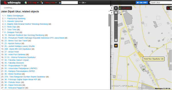
This afternoon, while pondering and daydreaming about seriously quitting OSM for real, I ventured into the land of Wikimapia.
One of the trickiest challenges in OSM is when a river (or any linear water feature) doubles as a regional or administrative boundary.
The Challenge of Dynamic Watercourses and Static Admin Lines 🌊🏛
While working on an OSM-related statistics project that I need to present in the next few months, I stumbled across some conversations of the past, scattered in changeset comments and block reports.
Yesterday, I was in a meeting of the HOT QCQA WG, when Patrik_B asked a question at the very end of the meeting.
Someone ask me for “What experience do you have building websites with Open Street Maps using controls limit then monitor and report on tile usage?”
According to the official statistics page, today OpenStreetMap has hit the milestone of 10 million registered users! This is not the first time though; in fact it already happened earlier this year and in 2023 (during which year the amount even excee…
I joined OSM from the https://deflock.me/ community, and have since added 21 ALPRs. Ive also contributed a few new developments to the map, and looking to add more.

Hello World
I joined OSM from the https://deflock.me/ community, and have since added 21 ALPRs. Ive also contributed a few new developments to the map, and looking to add more.OpenStreetMap
I see there’s an “OpenStreetMap US” but not “OpenStreetMap Illinois”?

Who's mapping around Central Illinois?
I see theres an OpenStreetMap US but not OpenStreetMap Illinois?OpenStreetMap
I’ve been editing OSM for about nine months and have been a heavy JOSM armchair editor for about eight months. Recently, I started using a stylus for entering geometry and it’s increased my stamina tremendously. I’ve been able to create hundreds even thousands of nodes per day without feeling any signs of repetitive strain injuries cropping up in my hand.

Using a Drawing Tablet for Editing in JOSM
Ive been editing OSM for about nine months and have been a heavy JOSM armchair editor for about eight months. Recently, I started using a stylus for entering geometry and its increased my stamina tremendously.OpenStreetMap
Someone ask me for “What experience do you have building websites with Open Street Maps using controls limit then monitor and report on tile usage?”
I’m currently exploring OpenStreetMap (OSM) and trying to understand what kind of real-world projects or applications can be built using it.
I’ve checked the documentation, but I’m still not sure how OSM data is typically used in actual applications or what kind of problems it can solve.
Could anyone please share:
Some common or professional use cases of OpenStreetMap
Any example project ideas or scenarios (personal, commercial, or open-source) where OSM is used effectively
Also, if possible, please suggest any recommended tools or libraries (like Leaflet, MapLibre, Nominatim, Overpass API, etc.) that are commonly used to work with OSM data.
Goal: I just want to get a clear idea of where OSM can be applied so I can plan my first project with it.
Thank you!

What are some practical use cases or project ideas using OpenStreetMap (OSM)?
Someone ask me for What experience do you have building websites with Open Street Maps using controls limit then monitor and report on tile usage?OpenStreetMap
I have been preparing a RFC for several days, but now weekend is over and i wont have time to finish things up. Heres drafted tldr of a draft of a RFC in case this ends up as another forgotten project. Scope of this proposal is limited to Estonia.
Started with Thurso on the North Highland Way. Our preferred hotel supplier is there
Started with Thurso on the North Highland Way. Our preferred hotel supplier is there
Started with Thurso on the North Highland Way. Our preferred hotel supplier is there
GO Sync seems to go a long way in comparing GTFS to OSM handily.
It’s still a very labor intensive process, even on a relatively sparse transit system like MetroLink.
It’s still a very labor intensive process, even on a relatively sparse transit system like MetroLink.
RapiD editor has rather unique feature that it can flag pedestrian crossings where node and way are tagged differently.
First post in hopefully a series of entries where Im planning to share various OSM-related experiments I have conducted over the years.
You can find a German version of this article here: Kreise in MapLibre
As an OpenStreetMap contributor, Ive always been dedicated to enhancing the detail and usability of local data.
To help make OSM more inclusive in line with the diversity statement https://osmfoundation.org/wiki/Diversity_Statement I’ve gone through the wiki and changed all relevant instances of specific pronouns to their gender neutral versions.

OSM Inclusivity
To help make OSM more inclusive in line with the diversity statement https://osmfoundation.org/wiki/Diversity_Statement I’ve gone through the wiki and changed all relevant instances of specific pronouns to their gender neutral versions.OpenStreetMap
Myanmar Earthquake 2025 - Bago Township Roads and Buildings Mapping Toady 200 edit Mapping Contribution done
Happy to be part of the Esri India User Conference—a great opportunity to learn new trends, attend practical sessions, and connect with industry experts and scientists. Grateful to my organization Jio-bp and my lead for giving me this chance to represent at the Esri India User Conference.
Take a look to watch they on the outside it ain’t safe to watch look alive
I’ve been mulling over an idea for a while: what if we grab a complete snapshot of OpenStreetMap data for a given region, then run some statistics over it?
