Welcome to my diary, Where did I macro-mapped This will be available in English and not Italian cuz:
1. I need to speak better english
2.
1. I need to speak better english
2.

Youve been involved with OpenStreetMap for at least 15 years, the interviewers begin, marking the start of the session.

The Ndomba Sector (Collectivé de Ndomba) is the easternmost sector of the Kabeya-Kamuanga Territory. While the eastern and southern borders of the sector are as well the borders of the territory (which have already been mapped for years), the western…
Im excited to share the midterm progress on my Google Summer of Code 2025 project: Temporary Road Closures Database and API for OpenStreetMap.
Date: 28 March 2024
Title: Planning & Co-Creation Workshop on Mapping Road Network of Karnali
Venue: Care Nepal, Sanepa
Organizer: Open Mapping Hub Asia Pacific
Led By: Rabi Shrestha, Sr. Field Mapping Expert & Prajwal Sharma, Jr.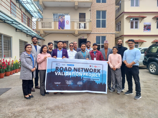
Title: Planning & Co-Creation Workshop on Mapping Road Network of Karnali
Venue: Care Nepal, Sanepa
Organizer: Open Mapping Hub Asia Pacific
Led By: Rabi Shrestha, Sr. Field Mapping Expert & Prajwal Sharma, Jr.
Co-Creation Workshop for Road Network Mapping in Karnali, Nepal
Date: 28 March 2024 Title: Planning & Co-Creation Workshop on Mapping Road Network of Karnali Venue: Care Nepal, Sanepa Organizer: Open Mapping Hub Asia Pacific Led By: Rabi Shrestha, Sr. Field Mapping Expert & Prajwal Sharma, Jr.OpenStreetMap
The Nominatim QA tool added a new layer Suspicious addr:state value
‘ve found myself drawn to a particular challenge: properly mapping the Rhondda Valleys in South Wales. It’s a task that’s proving both fascinating and frustrating in equal measure, but one that’s teaching me invaluable lessons about the complexities of local geography.
My approach has been quite straightforward - I’ve chosen to focus primarily on Ystrad, the area I know most intimately. This isn’t just because it’s familiar territory, but because understanding one place thoroughly seems like the best foundation for expanding outwards. Every quirk I discover, every mapping technique I develop, and every local peculiarity I uncover in Ystrad becomes a tool I can apply to neighbouring areas.
One of the most surprising aspects of this mapping project has been discovering just how much the “official” maps get wrong. I’ve taken to photographing street name signs and house numbers wherever I go - a habit that’s revealed some genuinely baffling discrepancies between reality and what appears on both Ordnance Survey maps and Google Maps.
The most striking example I’ve encountered is Bryn Terrace in Ystrad. This is a very real street, with real houses, real residents, and real post delivered daily. Yet somehow, it’s completely absent from both OS and Google mapping data. Walking down it, photographing the street sign, and checking my GPS coordinates left me questioning whether I was experiencing some sort of cartographic twilight zone. How does an entire street simply not exist in the digital world when it’s so clearly part of the physical one?
The house numbering systems throughout the Rhondda have provided another source of bewilderment. What might seem like straightforward sequential numbering often reveals itself to be anything but. Streets that appear to follow odd/even patterns suddenly throw in a completely out-of-sequence number, or entire ranges seem to have been skipped altogether.
These aren’t just historical quirks either - they’re active addresses that confuse delivery drivers and visitors alike. Mapping them accurately requires patient detective work, often involving conversations with locals who can explain the historical reasons behind these peculiarities. I recently found out about the note attribute, so I’m hoping to detail these nuances as I go along.
Each mapping session in teaches me something new about the challenges of accurately representing the real world in digital form. The lessons learned here - how to handle unusual address schemes, when to trust local knowledge over official sources, how to photograph evidence effectively - all prove invaluable when I venture into less familiar parts of the Rhondda.
What started as a simple desire to improve the map of my local area has evolved into a broader appreciation for the complexity of place. Every street name sign photographed, every GPS point recorded, and every correction made feels like a small victory in the ongoing battle to make OpenStreetMap truly representative of how people actually live and navigate their communities.
Our valley have decades of industrial and social history embedded in their geography, and much of that complexity isn’t captured in existing mapping data. Streets like Bryn Terrace might be missing entirely, whilst others are misnamed or incorrectly positioned.
By continuing this methodical approach, hopefully mastering Ystrad first, then expanding outwards with confidence - I’m hoping to contribute to a more accurate and useful map of this historically significant area of the world. After all, if we can’t get the basic building blocks right, how can we expect the map to serve the people who actually live here?
Onwards.
My approach has been quite straightforward - I’ve chosen to focus primarily on Ystrad, the area I know most intimately. This isn’t just because it’s familiar territory, but because understanding one place thoroughly seems like the best foundation for expanding outwards. Every quirk I discover, every mapping technique I develop, and every local peculiarity I uncover in Ystrad becomes a tool I can apply to neighbouring areas.
One of the most surprising aspects of this mapping project has been discovering just how much the “official” maps get wrong. I’ve taken to photographing street name signs and house numbers wherever I go - a habit that’s revealed some genuinely baffling discrepancies between reality and what appears on both Ordnance Survey maps and Google Maps.
The most striking example I’ve encountered is Bryn Terrace in Ystrad. This is a very real street, with real houses, real residents, and real post delivered daily. Yet somehow, it’s completely absent from both OS and Google mapping data. Walking down it, photographing the street sign, and checking my GPS coordinates left me questioning whether I was experiencing some sort of cartographic twilight zone. How does an entire street simply not exist in the digital world when it’s so clearly part of the physical one?
The house numbering systems throughout the Rhondda have provided another source of bewilderment. What might seem like straightforward sequential numbering often reveals itself to be anything but. Streets that appear to follow odd/even patterns suddenly throw in a completely out-of-sequence number, or entire ranges seem to have been skipped altogether.
These aren’t just historical quirks either - they’re active addresses that confuse delivery drivers and visitors alike. Mapping them accurately requires patient detective work, often involving conversations with locals who can explain the historical reasons behind these peculiarities. I recently found out about the note attribute, so I’m hoping to detail these nuances as I go along.
Each mapping session in teaches me something new about the challenges of accurately representing the real world in digital form. The lessons learned here - how to handle unusual address schemes, when to trust local knowledge over official sources, how to photograph evidence effectively - all prove invaluable when I venture into less familiar parts of the Rhondda.
What started as a simple desire to improve the map of my local area has evolved into a broader appreciation for the complexity of place. Every street name sign photographed, every GPS point recorded, and every correction made feels like a small victory in the ongoing battle to make OpenStreetMap truly representative of how people actually live and navigate their communities.
Our valley have decades of industrial and social history embedded in their geography, and much of that complexity isn’t captured in existing mapping data. Streets like Bryn Terrace might be missing entirely, whilst others are misnamed or incorrectly positioned.
By continuing this methodical approach, hopefully mastering Ystrad first, then expanding outwards with confidence - I’m hoping to contribute to a more accurate and useful map of this historically significant area of the world. After all, if we can’t get the basic building blocks right, how can we expect the map to serve the people who actually live here?
Onwards.
Mapping the Rhondda Valleys: A Local's Journey Through OpenStreetMap
ve found myself drawn to a particular challenge: properly mapping the Rhondda Valleys in South Wales. Its a task thats proving both fascinating and frustrating in equal measure, but one thats teaching me invaluable lessons about the complexities of l…OpenStreetMap
I wanted to share some analysis on a currently undefined part of the PWG Schema (Silver Tier specifically) that I originally posted on the OSM-US Slack.
OpenStreetMap is a map of the world, created by people like you and free to use under an open license.

Some websites allow users to post content with links to other sites and have previews for these links displayed alongside with the posts.
Those are typically social media sites, and well refer to them as social media in this diary entry.
Those are typically social media sites, and well refer to them as social media in this diary entry.
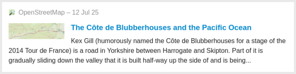
Following a suggestion by @andygol, I decided to refresh the Highway Tag Usage Scheme used by the Ukrainian OSM community. The original work on this scheme began back in 2013 — see the discussion in the Highways of Ukraine topic.
I continued on with the Happy Valley work, and found that I was able to do a portion of Johnny Hill Road.
I’ll be continuing on at this new pace.
I’ll be continuing on at this new pace.
Slowly working to edit and add information about public infrastructure, along with surveillance information.
Covered one side of Johnny Hill Drive between Hefler and Garland Street.
Hi OSM Community,
Today I added the location of our custom packaging workspace to the map to help local businesses and delivery services find us more easily. We specialize in producing eco-friendly and custom packaging solutions for food, retail, and cosmetic industries in the UK.
OpenStreetMap has been a great tool for navigating and contributing to local visibility. Mapping our business here also helps others discover nearby services and suppliers more efficiently.
If you’re ever searching for sustainable sandwich boxes, earring packaging, or cardboard containers, we’re here to help — and now easier to find on the map!
Looking forward to making more contributions to the platform soon.
Thanks, Custom Boxes UK
Today I added the location of our custom packaging workspace to the map to help local businesses and delivery services find us more easily. We specialize in producing eco-friendly and custom packaging solutions for food, retail, and cosmetic industries in the UK.
OpenStreetMap has been a great tool for navigating and contributing to local visibility. Mapping our business here also helps others discover nearby services and suppliers more efficiently.
If you’re ever searching for sustainable sandwich boxes, earring packaging, or cardboard containers, we’re here to help — and now easier to find on the map!
Looking forward to making more contributions to the platform soon.
Thanks, Custom Boxes UK
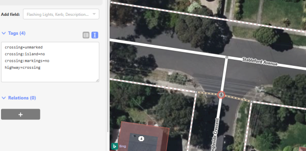
There has been a recent surge of interest in mapping walking infrastructure in Melbourne. This is very exciting because many parts have been lacking for a long time.
In Japan, when you buy tobaccos from a vending machine, you first have to prove that you are 20+ years old. Since 2008, The Japan Tobacconist Federation has been issuing taspo smart cards to adult smokers.
I added another set of buildings on Hamel Street and Garland Street. Had to also fix some naming issues on Hamel Street
I added another set of buildings on Hamel Street and Garland Street. Had to also fix some naming issues on Hamel Street
I added another set of buildings on Hamel Street and Garland Street. Had to also fix some naming issues on Hamel Street
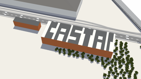
A collection/showcase of the different buildings and areas that I have mapped in 3D (through much trial and error). Each location has a link to view on OSM where you can see what building parts and tagging Ive used to represent these buildings.
I added several more houses sheds and garages to the Happy Valley Goose Bay area. I think that i will try to add more to other areas shortly, and speed up my time to a street a day so that I can start on other communities sooner.
I added several more houses sheds and garages to the Happy Valley Goose Bay area. I think that i will try to add more to other areas shortly, and speed up my time to a street a day so that I can start on other communities sooner.
I added several more houses sheds and garages to the Happy Valley Goose Bay area. I think that i will try to add more to other areas shortly, and speed up my time to a street a day so that I can start on other communities sooner.
Newark Fence Co is a townhouse complex in Rosenberger Dr, Middletown, DE 19709
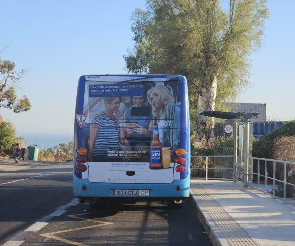
Recently Malagas bus route number 37 was extended to Residencia Santa Clara in the hills outside the city. This part of the route had been suspended for a few years, and I knew that some stops had been relocated in the meantime.
💕 https://www.openstreetmap.org/relation/1155266/history/177
💕 https://osm.mapki.com/history/relation/1155266#version-1
💕 https://osm.mapki.com/history/relation/1155266#version-1
bus route v177 for bas 177
💕 https://www.openstreetmap.org/relation/1155266/history/177 💕 https://osm.mapki.com/history/relation/1155266#version-1OpenStreetMap
I added several extra parts to Hamel Street, which I had to name, because apparently there hadn’t been a name available on it. I added several houses, and will add more soon.
I added data to the Mauritania mapping for the agricultural component of the UN. Most of these appear to have been a result of the shape of the landscape, around the farmland.
I think that next time I will use the Josm tool.
I added data to the Mauritania mapping for the agricultural component of the UN. Most of these appear to have been a result of the shape of the landscape, around the farmland.
I think that next time I will use the Josm tool.
I think that next time I will use the Josm tool.
I added data to the Mauritania mapping for the agricultural component of the UN. Most of these appear to have been a result of the shape of the landscape, around the farmland.
I think that next time I will use the Josm tool.
Adding Data to the HOT Task
I added data to the Mauritania mapping for the agricultural component of the UN. Most of these appear to have been a result of the shape of the landscape, around the farmland. I think that next time I will use the Josm tool.OpenStreetMap
A style using the Shortbread vector tiles is now live on OpenStreetMap.org. Theres been some minor issues with the roll-out, but nothing that caused me to panic.
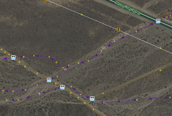
Many OSM validators will report an error if a crosses a without some additional tags or structure at the intersection, such as a bridge, culvert, or ford.
I like to map trees. Last year, I wrote a diary about trees mapping, a wiki page to document tagging of Italian monumental trees tagging, a trivia thread about the tallest trees in the database etc.

Slowly working to edit and add information about public infrastructure, along with surveillance information.

I havent written anything in this diary yet, so I decided to just do that.

Al Nabi Colony, Gujrat, Punjab, Pakistan Sells groceries, snacks, and daily household items. This is a physical and actively operating business.
April 15–19, 2025, proved to be a special landmark in my mapping experience when I participated in the OSM Spring Mapathon 2025, sponsored by Youth Innovation Lab. I am excited to announce that I won the Beginner Category for 22,922 map changes!
This acknowledgement is meaningful to me—not only as a personal achievement, but also as a personal reminder of my growth since first hearing about OpenStreetMap (OSM) during 2021. At that time, OSM was merely another name, still learning its way into my periphery. Little did I realize the meaning that OSM would take on as an important part of my learning and contribution trajectory.
I committed a certain amount of time each day during the Mapathon to updating map data. Anything from adding roads, perfecting building footprints, or fixing map glitches and errors. Each change adding to a sense of satisfaction that somewhere someone would benefit from finally going through something that they could map out into a community, and their community becoming visible, sharing their data.
The event itself was inspiring. While Youth Innovation Lab was the primary host, the Mapathon brought together fellow mappers from across the land, and beyond. Each day’s schedule created an exciting and competitive environment that made staying sedimentary contagious.
Though I did not expect to win the Beginner Category, I am even more so grateful. The motivation of this experience is further proof that with the appropriate due diligence, sprinkling curiosity and learning, anything is possible!
This acknowledgement is meaningful to me—not only as a personal achievement, but also as a personal reminder of my growth since first hearing about OpenStreetMap (OSM) during 2021. At that time, OSM was merely another name, still learning its way into my periphery. Little did I realize the meaning that OSM would take on as an important part of my learning and contribution trajectory.
I committed a certain amount of time each day during the Mapathon to updating map data. Anything from adding roads, perfecting building footprints, or fixing map glitches and errors. Each change adding to a sense of satisfaction that somewhere someone would benefit from finally going through something that they could map out into a community, and their community becoming visible, sharing their data.
The event itself was inspiring. While Youth Innovation Lab was the primary host, the Mapathon brought together fellow mappers from across the land, and beyond. Each day’s schedule created an exciting and competitive environment that made staying sedimentary contagious.
Though I did not expect to win the Beginner Category, I am even more so grateful. The motivation of this experience is further proof that with the appropriate due diligence, sprinkling curiosity and learning, anything is possible!
HOT#OSM#Youth Innovation Lab# OSM Spring Mapathon2025
As you might know, were having OpenStreetMap Awards this year! Finally, after many skipped years, we will have the honour and the joy to recognize people and teams who have made an impact on OSM, whether its by mapping, writing, or coding!
Tagging and additions of USFS roads in the Siuslaw National Forest completed.
In 2020, I was presented with an opportunity to participate in the Humanitarian OpenStreetMap Team’s Data Quality Internship, https://www.hotosm.
HOT Data Quality Internship
In 2020, I was presented with an opportunity to participate in the Humanitarian OpenStreetMap Team’s Data Quality Internship, https://www.hotosm.OpenStreetMap
Questions
- Does OSM track the last time a user made an diary entry?
- Does the last map edit timestamp on a user’s profile indicate only the edits made to maps or diaries and notes as well?