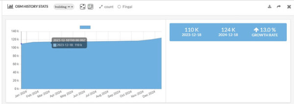
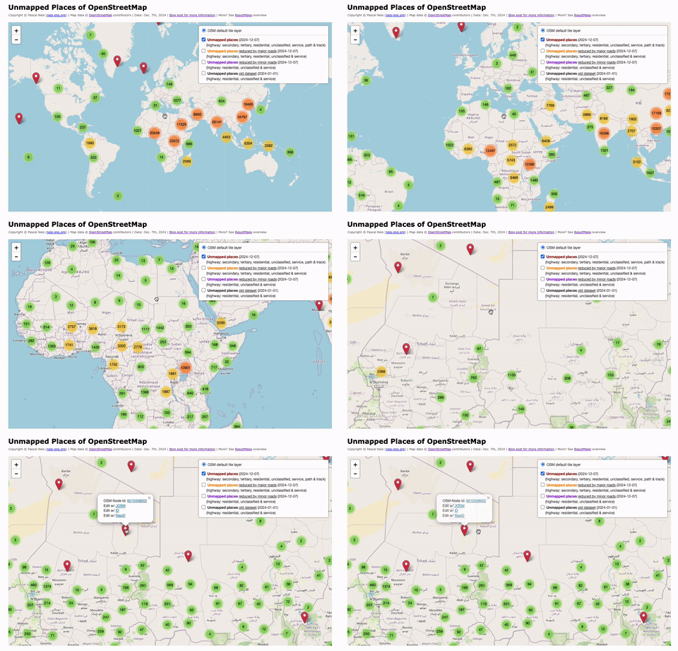
As time passes I am delving further into the discovery that I outlined here, and contextualised a little more here and all relating to the Fingal task set up by myself and the osm community three years ago.
Since yesterday, weve updated our Map of Mithraea using OpenStreetMap and Leaflet – and were quite pleased with the result!
On the 22nd and 23rd of November 2024, I visited the Ho Technical University (HTU) YouthMappers chapter for an exciting two-day program sponsored by OSM Ghana.
Im deleting OSM node 151352138 which was place=hamlet name=Dominion within the city of Longmont, CO (at 40.1430404, -105.1269286)
Local languages of openstreetmap
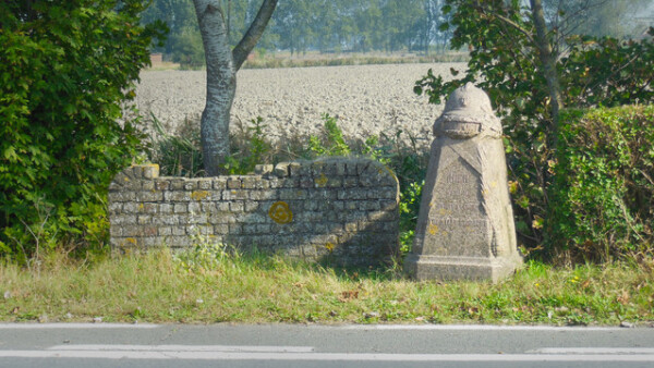
Earlier today I OSM-stumbled upon a stele marking the western front line of the First World War in Belgium and France. In Dutch we apparently call them demarcatiepalen, a term which I find amusingly technical sounding.
This last 5 years I have been faced with a terrifyingly real and all consuming gang stalking problem (concept which I didn’t even fully believe in until at the grips of it myself), bringing with it cognitive dissonance, dissociation and confusion through gas-lighting, bullying, financial and emotional abuse by those who are supposed to be closest to me.
By deliberately noticing everything it encompasses, and by thoroughly researching each of it’s composing elements to be able to represent them with as much fidelity as possible, I hope to regain some sense of direction and purpose and find refuge from stagnancy, isolation and depression.
it feels like I have lost all sense of footing; like solid ground could very well turn out to have been ocean this whole time and it would not be all that shocking.My participation in this project is an attempt to help me reconnect with myself and my surroundings
By deliberately noticing everything it encompasses, and by thoroughly researching each of it’s composing elements to be able to represent them with as much fidelity as possible, I hope to regain some sense of direction and purpose and find refuge from stagnancy, isolation and depression.
Hi, my name is Joh,
and I will stand strong and make best of this, and every situation.
I shall bend not break,
I shall be,
Because I have as much right to do so as everyone else.
finding my footing
This last 5 years I have been faced with a terrifyingly real and all consuming gang stalking problem (concept which I didnt even fully believe in until at the grips of it myself), bringing with it cognitive dissonance, dissociation and confusion thro…OpenStreetMap
This is the developers diary concerning the fifth year of the damn project the project that helps mappers by dividing a big area into smaller planar shapes that people can map together.
2024…I’ve learned a lot of things…
- I mapped some trees at my university.
- I love nature! So I helped @Ludway map his school with some kids. There, I practiced my knowledge of trees and species. I learned how to measure a tree! Also, I learned about some botanical things.
- I mapped my neighborhood and learned how to map buildings, shops, paths, etc.
- Now I’m envolved in YouthMappers, and I’m very proud of that.
- I met amazing people like @AngocA, @JuanMelo and @Isbravoc, who have taught me many things.
It has been a productive year for me on osm yet I am still reaching for a more comprehensive map of both Anchorage and greater Alaska.
This year I continued to map large swathes of natural features in Alaska. It is still very much an open canvas to add features and without even a goal in mind it has been easy and quick to add large areas in small osm breaks throughout the day in 2024. Corollary studies published this year on the prevalence of Alzheimer’s based on occupation points to reduces occurrences with jobs requiring constant active direction finding (ambulance drivers and taxi drivers in particular). It’s been hypothesized this is from activation or stimulation of the hippocampus. That’s something I imagine I can trigger to some degree with mapping that I wouldn’t get from my typical computer work. I feel as though osm is keeping my brain sharp at least.
And while the blank canvas of Alaska is a very freeing, It can be slightly frustrating that the audience for these remote areas are close to zero. To attract a larger audience, I have a plan for 2025. What really needs doing is the large natural feature additions where they can be viewed at the lower zoom levels. The natural goal for me then is some continuous line that would be interesting to see for viewers of Alaska between zooms around 6 or 7. It would be a thin line, since the distance is vast but the perfect goal would also attract help from other users as well I believe. With these considerations in mind, my goal for 2025 is to create a continuous line of natural features along the famous Alaska Iditarod Dog Sled Race. It garners more international attention then maybe any other Alaska specialty other than salmon. The race is approximately a round 1000 miles (1600 km) which fits within a stretch goal for a year I believe. Since this is still a very large goal, even as a very thin line, I will tip my toe into the community a little more to see where I can pick up edits on this goal from the international community.
The overpass turbo API within R is exceptional. The workflow is fast between edits, API call, and resulting table or leaflet map. I am continuing to play with the possibilities of this like I have written before in previous journal entries beyond basic mapping. It scratched my itch for studying infrastructure both locally and far away. Of course, while only the mapped information is accessible, all sorts of informal questions I come up with from reading the news become easy querys. What’s the pipeline infrastructure of the permian basin look like? Where are the military installations within China? These are quick and answerable questions! It’s nuts this isn’t utilized more.
Taking this as my supposition, how then should I focus my attention for 2025 instead of following my curiosity? Not that there’s anything wrong with that though.
Well for this coming year, I think that I would very much like to find the right workflow to making my questions and answers more public. I’m going to make a public website to host these leaflet maps I make for myself with more of the story behind my interests. This could look like showing local combustion car infrastructure across localities (gas stations, dealerships, mechanics, etc.) given the general interest in electric vehicles or something like a regional map satellite Smithsonian museums. I will have to wait to see what moves me (and most importantly, commit to hosting my work outside this journal.
2024 has included a full survey of Anchorage places of worship including contact information where I can find it. I have hope in 2025 to fill in the address information and export this information to make a kind of local directory of places of worship in Adobe InDesign with a map to accompany it with indexed locations. If my goal is achieved, I think then it would be a low labor path to produce more directories with local businesses, schools, etc. utilizing the osm database with the overpass api. I haven’t seen anyone else do this to what I would consider a finished product and while the scale of Anchorage is fairly small compared to other large metros, this would be a great way to expand the scope for how osm data could be used.
Happy 2025!
Mapping Natural Features
This year I continued to map large swathes of natural features in Alaska. It is still very much an open canvas to add features and without even a goal in mind it has been easy and quick to add large areas in small osm breaks throughout the day in 2024. Corollary studies published this year on the prevalence of Alzheimer’s based on occupation points to reduces occurrences with jobs requiring constant active direction finding (ambulance drivers and taxi drivers in particular). It’s been hypothesized this is from activation or stimulation of the hippocampus. That’s something I imagine I can trigger to some degree with mapping that I wouldn’t get from my typical computer work. I feel as though osm is keeping my brain sharp at least.
My First 2025 Goal
And while the blank canvas of Alaska is a very freeing, It can be slightly frustrating that the audience for these remote areas are close to zero. To attract a larger audience, I have a plan for 2025. What really needs doing is the large natural feature additions where they can be viewed at the lower zoom levels. The natural goal for me then is some continuous line that would be interesting to see for viewers of Alaska between zooms around 6 or 7. It would be a thin line, since the distance is vast but the perfect goal would also attract help from other users as well I believe. With these considerations in mind, my goal for 2025 is to create a continuous line of natural features along the famous Alaska Iditarod Dog Sled Race. It garners more international attention then maybe any other Alaska specialty other than salmon. The race is approximately a round 1000 miles (1600 km) which fits within a stretch goal for a year I believe. Since this is still a very large goal, even as a very thin line, I will tip my toe into the community a little more to see where I can pick up edits on this goal from the international community.
My Second 2025 Goal
The overpass turbo API within R is exceptional. The workflow is fast between edits, API call, and resulting table or leaflet map. I am continuing to play with the possibilities of this like I have written before in previous journal entries beyond basic mapping. It scratched my itch for studying infrastructure both locally and far away. Of course, while only the mapped information is accessible, all sorts of informal questions I come up with from reading the news become easy querys. What’s the pipeline infrastructure of the permian basin look like? Where are the military installations within China? These are quick and answerable questions! It’s nuts this isn’t utilized more.
Taking this as my supposition, how then should I focus my attention for 2025 instead of following my curiosity? Not that there’s anything wrong with that though.
Well for this coming year, I think that I would very much like to find the right workflow to making my questions and answers more public. I’m going to make a public website to host these leaflet maps I make for myself with more of the story behind my interests. This could look like showing local combustion car infrastructure across localities (gas stations, dealerships, mechanics, etc.) given the general interest in electric vehicles or something like a regional map satellite Smithsonian museums. I will have to wait to see what moves me (and most importantly, commit to hosting my work outside this journal.
My Third 2025 Goal
2024 has included a full survey of Anchorage places of worship including contact information where I can find it. I have hope in 2025 to fill in the address information and export this information to make a kind of local directory of places of worship in Adobe InDesign with a map to accompany it with indexed locations. If my goal is achieved, I think then it would be a low labor path to produce more directories with local businesses, schools, etc. utilizing the osm database with the overpass api. I haven’t seen anyone else do this to what I would consider a finished product and while the scale of Anchorage is fairly small compared to other large metros, this would be a great way to expand the scope for how osm data could be used.
Happy 2025!
# My Experience Mapping Trees With High School Students at Instituto Técnico Industrial Francisco José de Caldas

# My Experience Mapping Trees With High School Students at Instituto Técnico Industrial Francisco José de Caldas
OpenStreetMap is a map of the world, created by people like you and free to use under an open license.OpenStreetMap
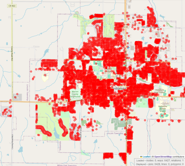
As I wrote some time ago, I started mapping (remotely) in Indianola, Iowa. I have now reached completion (as complete as it can be with the imagery available) with buildings and added more street furniture, minor etc.
Well over a year ago I extracted all the objects for Great Britain. Nearly 860 keys are used across all the elements.
📅 Date: November 30th - December 1st, 2024
🌍 Location: Cox’s Bazar, Bangladesh
🏷️ Hashtags: #SotM2024 #OMGuru #YouthMappers #EasternUniversity #OSM #MappingForChange #GeospatialRevolution
🌍 𝔸 𝕁𝕠𝕦𝕣𝕟𝕖𝕪 𝕠𝕗 𝕀𝕟𝕟𝕠𝕧𝕒𝕥𝕚𝕠𝕟, ℂ𝕠𝕝𝕝𝕒𝕓𝕠𝕣𝕒𝕥𝕚𝕠𝕟, 𝕒𝕟𝕕 ℂ𝕠𝕟𝕟𝕖𝕔𝕥𝕚𝕠𝕟
The…
🌍 Location: Cox’s Bazar, Bangladesh
🏷️ Hashtags: #SotM2024 #OMGuru #YouthMappers #EasternUniversity #OSM #MappingForChange #GeospatialRevolution
🌍 𝔸 𝕁𝕠𝕦𝕣𝕟𝕖𝕪 𝕠𝕗 𝕀𝕟𝕟𝕠𝕧𝕒𝕥𝕚𝕠𝕟, ℂ𝕠𝕝𝕝𝕒𝕓𝕠𝕣𝕒𝕥𝕚𝕠𝕟, 𝕒𝕟𝕕 ℂ𝕠𝕟𝕟𝕖𝕔𝕥𝕚𝕠𝕟
The…

𝑼𝒏𝒊𝒕𝒆, 𝑰𝒏𝒔𝒑𝒊𝒓𝒆, 𝑰𝒏𝒏𝒐𝒗𝒂𝒕𝒆: 𝑴𝒚 𝑻𝒓𝒂𝒏𝒔𝒇𝒐𝒓𝒎𝒂𝒕𝒊𝒗𝒆 𝑱𝒐𝒖𝒓𝒏𝒆𝒚 𝒂𝒕 𝑺𝒕𝒂𝒕𝒆 𝒐𝒇 𝒕𝒉𝒆 𝑴𝒂𝒑 𝑨𝒔𝒊𝒂 2024
📅 Date: November 30th - December 1st, 2024 🌍 Location: Cox’s Bazar, Bangladesh 🏷️ Hashtags: #SotM2024 #OMGuru #YouthMappers #EasternUniversity #OSM #MappingForChange #GeospatialRevolution 🌍 𝔸 𝕁𝕠𝕦𝕣𝕟𝕖𝕪 𝕠𝕗 𝕀𝕟𝕟𝕠𝕧𝕒𝕥𝕚𝕠𝕟, ℂ𝕠𝕝𝕝𝕒𝕓𝕠𝕣𝕒𝕥𝕚𝕠𝕟, 𝕒𝕟𝕕 ℂ𝕠𝕟𝕟𝕖𝕔𝕥𝕚𝕠𝕟 The…OpenStreetMap
The Health Benefits of Editing OpenStreetMap (Made by AI)
Engaging in OpenStreetMap (OSM) editing is not just a hobby for geography enthusiasts—it is a multifaceted activity that provides numerous health benefits. From mental stimulation to physical activity, the act of mapping offers opportunities to enhance overall well-being in surprising ways.
One of the primary mental benefits of editing OSM is improved cognitive function. Mapping tasks require problem-solving, attention to detail, and spatial reasoning, all of which help sharpen the mind. Additionally, OSM editing fosters a sense of achievement and purpose. Completing map edits, especially those that contribute to disaster relief or accessibility, can boost self-esteem and provide emotional satisfaction. This altruistic aspect of OSM offers a unique source of fulfillment, as contributors know their work directly benefits communities worldwide.
Editing OSM also serves as a form of stress relief. The focused and repetitive nature of mapping encourages mindfulness, helping to calm the mind and reduce anxiety. By offering a meaningful distraction from daily worries, it can become a therapeutic activity. Moreover, participating in the global OSM community provides opportunities for social interaction, whether through online forums or collaborative mapping events. These connections can alleviate feelings of isolation and enhance mental well-being.
On a physical level, OSM editing often involves outdoor exploration, such as verifying map data through fieldwork. Activities like walking or cycling to map areas promote cardiovascular health, improve fitness, and provide an enjoyable way to engage with nature. For those working primarily indoors, field mapping offers a refreshing break from sedentary routines, benefiting posture, reducing eye strain, and encouraging movement.
Finally, OSM editing encourages lifelong learning. Contributors continually acquire new skills, from mastering mapping software to understanding geographic trends and urban planning. This mental engagement keeps the brain agile and adaptable, supporting long-term cognitive health.
In conclusion, editing OpenStreetMap is a rewarding activity with wide-ranging health benefits. It sharpens the mind, nurtures emotional well-being, promotes physical activity, and connects individuals to a global community. By contributing to a cause that impacts people worldwide, OSM editing exemplifies how a simple hobby can significantly enhance personal health and happiness.

The health benefits of editing OSM (Made by AI)
The Health Benefits of Editing OpenStreetMap (Made by AI)OpenStreetMap
A few years ago I started working to make my town, Glenrothes, more visible on the Open Street Map. Mostly it was just roads and land use imported from public data, though a few people had added in some housing areas, addresses, and point of interest. I have steadily been adding all the missing buildings, shops, addresses, other missing POIs and cleaning up major land use blocks.
It is far from perfect, but things are in a much better state than they were a few years ago. But there are still a few areas where data needs to be added. If possible, it would be nice to address these in the coming year:
I mostly use StreetComplete for surveying, and that has had quite a few updates this year, making it ever easier to use. This year I discovered the Rapid editor which is really useful for adding data to unmapped areas in other parts of Scotland.
I hope all the OSM mappers had a good 2024, and wishing you a good 2025, too!
It is far from perfect, but things are in a much better state than they were a few years ago. But there are still a few areas where data needs to be added. If possible, it would be nice to address these in the coming year:
- Finish adding the remaining missing addresses - There are a lot of neighbourhoods still missing address data. The UK’s PAF still hasn’t been released under open license, so these will need to be surveyed and added manually. In clockwise order: Collydean, Pitcairn, Balfarg, Cadham, Markinch, Thornton, Stenton, Caskieberran, Stenton, and Leslie. I want to be accurate though, and the layouts of houses in same areas can be difficult to navigate, so it may take some time.
- More details for POIs like shop opening hours - Locations on the OSM can have additional metadata like contact details, opening hours, whether they are disabled accessible, and things like types of menu for restaurants. Some of this info is made available on websites, some of it may need direct surveying.
- There are lots of construction areas around town that will need to be surveyed when they are complete. New buildings and POIs to be added. The town park is also being upgraded and when it is finished next year there may be lots of changes to update, like new paths and play areas. Some of these changes have already been updated.
I mostly use StreetComplete for surveying, and that has had quite a few updates this year, making it ever easier to use. This year I discovered the Rapid editor which is really useful for adding data to unmapped areas in other parts of Scotland.
I hope all the OSM mappers had a good 2024, and wishing you a good 2025, too!

Open Street Map Goals for 2025
A few years ago I started working to make my town, Glenrothes, more visible on the Open Street Map. Mostly it was just roads and land use imported from public data, though a few people had added in some housing areas, addresses, and point of interest…OpenStreetMap
In 2010, I first conducted a study which identified regions (places) in the OpenStreetMap (OSM) project in Germany that still had potential for more detailed mapping. Later, in 2016, this analysis was repeated and extended to the entire world.
MiKlo:~/citizen4.eu$💙💛udostępnił to.
Happy Festivus from the Rapid Team! Today we released v2.5 of the Rapid editor for OpenStreetMap just in time for the “Feats of Strength” 💪
Our agency has decided to contribute our mapping expertise to Eastvale, California, through the end of 2024. Eastvale has been without address data for turn-by-turn navigation apps for quite some time, and were committed to helping fill this gap.
Ah, State of the Map! The pinnacle annual gathering of our own kind, where we, the OSM community, come together to exchange insights, celebrate achievements, and explore the latest advancements in technology.
How was my experience overall, you may ask? Eight days of relentless effort—rushing between offices to complete my passport and visa, and spending countless hours traveling on various modes of transport—just to attend a weekend-long conference. Was it worth it? Absolutely, without a doubt! In fact, I’d gladly go through it all again in a heartbeat.
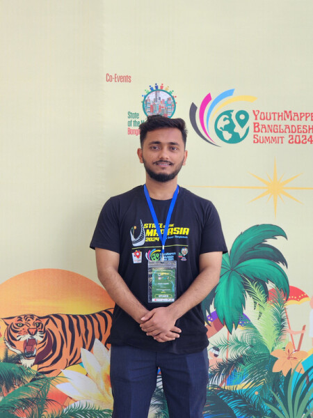
This experience was nothing short of incredible. It was a joy and privilege to finally meet Mikko Tamura, Honey Fombuena, Harry Mahardhika, Nama Raj Budhathoki from HOT, and so many other inspiring individuals from the Bangladesh and Nepal OSM communities, as well as the vibrant YouthMappers network. Their boundless energy, unwavering passion for improving OpenStreetMap (OSM), and commitment to encouraging mass adoption left a profound impression on me.
Connecting with them wasn’t just about OSM; it was about engaging with a group of extraordinary people whose enthusiasm and vision resonate deeply. Their drive to create positive change is quite something, and I am more motivated than ever to channel that same spirit into my own initiatives in the near future.
The weekend wasn’t just a conference—it was a gathering of minds, a celebration of shared purpose, and an unforgettable opportunity to be part of a community that genuinely inspires. I am immensely grateful for every moment of it.
I’ve been mapping in Alaska for quite some time now, with a specific interest in mapping national parks, forests, and other protected areas. It has become apparent to me that much of the state, with the exception of southeast Alaska, lacks sufficient hydrographic data in the map. I’ve been working on chipping away at this problem intermittently, adding lakes and named waterways. However, given the size of interior Alaska’s national and state parks, attempting large scale additions by hand would be prohibitively time consuming.
I’ve gained a good deal of familiarity over the years with the software needed to perform an import of USGS National Hydrographic Dataset data to fill this gap. My current idea is to download the needed NHD dataset from the USGS website, convert it to .shp in QGIS, delete all tags from the data and split it to smaller files. I would then load the raw shapes into JOSM using the opendata plugin and add tags manually. I would avoid conflicts with existing data by loading it into the editor prior to loading the .shp, thus allowing me to integrate the data more seamlessly.
I am aware that it is customary to receive community buy in before beginning an import project. I’ve run into some confusion on this as Alaska has a very small OSM community that is not well established. I could contact a few mappers individually, but I am not sure if that alone would satisfy the need for community buy in.
I’m curious as to what input people have on this

Interior and northern Alaska NHD import
Ive been mapping in Alaska for quite some time now, with a specific interest in mapping national parks, forests, and other protected areas.OpenStreetMap
I have not participated in so many State of the Map conferences, only in two LATAM conferences, the first one being Sao Paulo in 2016, historical for me since the Geochicas were founded on this occasion and the following year in 2017 in Lima.
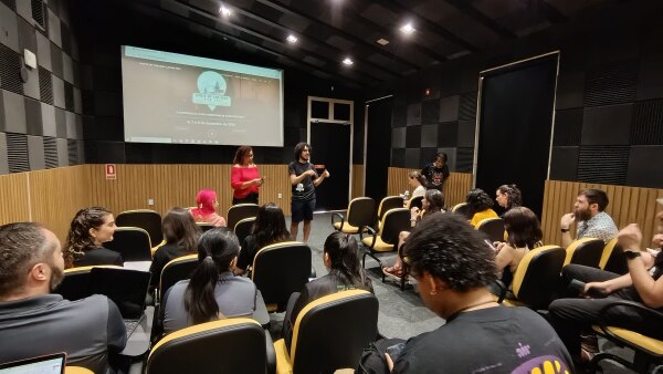
Nosso capítulo completou 1 ano de existência em maio de 2024 e continuamos a pleno vapor, com atividades abertas de mapeamento e de capacitação em OpenStreetMap.
(https://commons.wikimedia.org/wiki/File:Cox%27s_Bazar_(black_and_white).jpg)

On the Horizon
(https://commons.wikimedia.org/wiki/File:Cox%27s_Bazar_(black_and_white).jpg)OpenStreetMap
My excitement was extremely high since I had come to know that this year’s State of the Map Asia would take place in the beautiful setting of Cox’s Bazar in Bangladesh for the very first time.
I am @SantiViajaSimplemente to see the pictures… Now in Colombia after 86 countries
Introduction
During the COVID-19 pandemic, like many others, I found myself immersed in online classes and scrolling through social media during breaks. One day, I stumbled across OpenStreetMap (OSM), and my journey with this incredible platform began out of sheer curiosity. Little did I know that this discovery would eventually lead me to the State of the Map Asia 2024 conference—my first-ever conference application. I cannot express the joy I felt when both my presentation and I were selected to be part of this esteemed event. Though I received only a partial scholarship, I was determined to make it to Cox’s Bazar, Bangladesh. Traveling from Nepal, we were a group of four. I had already booked my flight, which departed from Delhi, while my friends flew directly from Kathmandu.
The Journey to Cox’s Bazar
The journey wasn’t without its challenges. I had a tight three-hour transit in Dhaka to catch my domestic flight to Cox’s Bazar. However, my international flight faced delays, and applying for a visa on arrival meant standing in a long queue. Fearing I might miss my next flight, I humbly requested the visa officer to expedite my process. Time was of the essence, so I couldn’t exchange currency or get a local SIM card. With only minutes to spare, I dashed to the domestic terminal, relieved to find that my domestic flight was also delayed by an hour. I was informed by Sawan Sir that I would meet Hasna Heena and Fazle Rabbi at the airport, which comforted me as they were on the same flight. True to their reputation, the lovely couple warmly welcomed me, helped me exchange currency, and ensured I felt at home upon reaching the hotel.
First Impressions
I reached Cox’s Bazar on November 29, 2024, and was greeted with a mesmerizing view of the sea. Seeing the ocean for the first time was a surreal experience, but the hot weather and conference preparations kept me from enjoying it immediately. At the venue, I met my friends from Nepal and Bangladesh, along with other participants. The atmosphere was vibrant, filled with anticipation for the upcoming sessions.
The Conference Experience
The two-day conference, held from November 30 to December 1, 2024, was packed with insightful presentations and discussions. Nama Raj Budhathoki, from the Open Mapping Hub Asia Pacific, delivered a captivating keynote speech to kick off the event. Topics such as disaster resilience, women’s safety, and UAV basics caught my attention. I particularly enjoyed the session on “From Data to Action: Creating 3D Flood Visualizations with Open Source Tools like OSM and QGIS,” which was both innovative and inspiring.
My Presentation
On the second day, I delivered my presentation titled “Mapping Critical Infrastructures for Disaster Resilience Using OpenStreetMap.” It was my first time speaking at such a prestigious event, and I admit I felt a bit nervous. My presentation focused on the importance of mapping critical infrastructures and its necessity in various scenarios. For instance, during a flood, mapped features enable quick access to safe spaces and evacuation shelters, as well as identifying the safest and shortest routes. Similarly, in unfamiliar locations, having the mapped locations of health facilities can be lifesaving in emergencies, allowing patients to receive timely medical attention. However, as I began speaking.However, seeing Hasna Heena nodding encouragingly from the front row and recognizing familiar faces like Kazi Arifin Jamil among the audience gave me confidence. Their support turned what could have been a nerve-wracking experience into a memorable one.
Beyond the Conference
we had the opportunity to visit the beach, where we savored delicious local seafood alongside friends from various countries. The camaraderie among participants was truly uplifting, and the “OSM Guru Dinner” on the final evening provided a perfect conclusion to the event. During the dinner, we shared our OSM journeys, reflected on the critical role of data validation, and envisioned the future possibilities of open mapping. A heartfelt thanks to Azar, Ibtehal, Nodi, and everyone else who went above and beyond to make us feel welcomed and at home in Bangladesh. This conference was also an opportunity to reconnect with familiar faces like Mikko, Honey, and Harry, whom I had previously met at SLSI and Kathmandu University. The event concluded with awards for poster presentations, Mapper of the Year, and other activities, leaving everyone with a sense of accomplishment and inspiration.
Reflections
State of the Map Asia 2024 was a transformative experience for me. From overcoming travel hurdles to presenting my work on an international platform, this journey has been one of growth and learning. I am grateful for the State of Map Asia team, friends, mentors, and opportunities that OSM has brought into my life. This event not only deepened my understanding of open mapping but also reinforced my commitment to leveraging OSM for community resilience and development.
This is my first major mapping project on OpenStreetMap, and I’m calling it the StephenvilleTX Project. I’ve been spending a lot of time refining the roads and overall layout of the city, and it’s been both an exciting and challenging experience.
A Memorable Experience
When I received the news about the State of the Map Asia 2024 in Cox’s Bazar, I was filled with excitement. I was traveling from Chattogram to Cox’s Bazar for this conference was a new adventure. As a Campus Ambassador for the University of Chittagong and a representative of the CUSS YouthMappers Chapter, attending this event was a great honor. The accommodation scholarship I received allowed me to stay at Hotel Prime Park, making the entire experience even more special.
The Journey Begins
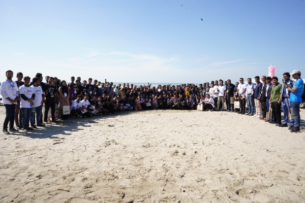
The journey from Chattogram to Cox’s Bazar on November 29th was filled with excitement and anticipation. I traveled with one of my friends and three juniors, all of whom were equally excited. Along the way, the scenic beauty of the surroundings made the trip more enjoyable, and we couldn’t help but look forward to what awaited us in Cox’s Bazar. Upon arrival, we were welcomed by the warm hospitality of our hosts, and everything went smoothly. The city of Cox’s Bazar, with its stunning 120 km-long beach, was unlike anything I had ever seen before. The beauty of the sea and the peaceful atmosphere left me in awe, and we made sure to capture some special moments, including drone shots of the beach, thanks to Krishna Prashad Mondal Dada. The entire trip, both to and from Cox’s Bazar, was truly an enjoyable experience.
The Conference Experience
Attending State of the Map Asia 2024 was an eye-opening experience. The sessions and workshops were rich with knowledge, especially the WebMapping workshop, which was completely new to me. I learned about various aspects of web mapping, which opened up a whole new area of interest for me. The event was an opportunity to meet passionate mappers, developers, and experts from various backgrounds. I was particularly excited to connect with members of the Jahangirnagar University YouthMappers Chapter, and it was great to see the collaborative spirit in action. The conference highlighted the diverse applications of OpenStreetMap (OSM), and I felt truly inspired by the ways OSM is being used to solve real-world problems, especially in humanitarian efforts and disaster risk reduction. The workshops were hands-on, and I appreciated the chance to learn practical skills that I look forward to applying in my future endeavors.
Networking and Connections
Beyond the learning, one of the best parts of the conference was meeting so many people from the OSM community. I made connections with individuals I had only interacted with online before. The experience of sharing ideas and stories in person was truly invaluable. One of the highlights of the event was meeting a senior from our university unexpectedly. It made the experience even more enjoyable as we were able to enjoy the entire event together.
The Beach Experience
One of my favorite memories was our time at the beach. The opportunity to relax and enjoy the natural beauty of Cox’s Bazar was refreshing. The drone shots captured by Krishna Prashad Mondal Dada provided a stunning perspective of the landscape, and it was a moment we will all remember.
Heartfelt Thanks
A special thanks to the State of the Map Asia 2024 organizing committee for hosting such a well-executed and inclusive event. I am particularly grateful to Sawan Sharir, Mikko, Honey Grace Fombuena, Harry Mahardhika Machmud, and the Open Mapping Hub - Asia Pacific for creating such a fantastic platform for learning, collaboration, and community-building. Special thanks to Amena Rashid Bania Apu for her encouragement and support throughout the conference. I would also like to thank Krishna Prashad Mondal Dada for capturing the amazing drone shots at the beach. I am also grateful to the State of the Map Asia 2024 organizing team, the YouthMappers community, and everyone who made this event possible. Your efforts gave me such a rewarding experience, and I am truly thankful. Thanks to CUSS YouthMappers Chapter for their unwavering support, and to my two friends and two juniors for joining me on this journey. Their enthusiasm made the experience even more enjoyable, and we all shared some unforgettable moments together.
Reflecting on the Journey
As I returned to Chattogram on December 1st, I felt deeply inspired by the knowledge and connections I had gained at State of the Map Asia 2024. The experience was enriching, and I am more motivated than ever to contribute to the OpenStreetMap community. It was not just a conference, but a celebration of the power of maps, collaboration, and the global community that drives meaningful change.
#My Journey to State of the Map Asia 2024:
When I received the news about the State of the Map Asia 2024 in Coxs Bazar, I was filled with excitement. I was traveling from Chattogram to Coxs Bazar for this conference was a new adventure.OpenStreetMap
On November 30 and December 1, 2024, the breathtaking shores of Cox’s Bazar played host to an extraordinary gathering of mapping enthusiasts, community leaders, and changemakers at State of the Map Asia 2024! This landmark event brought together the …
When I first received the email confirming my scholarship to attend State of the Map Asia 2024 in Coxs Bazar, Bangladesh, I was overjoyed.
Cox’s Bazar, the breathtaking coastal city of Bangladesh, recently hosted the State of the Map Asia 2024 conference. For me, as an enthusiastic mapper, participating in this event was nothing short of a dream come true.
This year, I had the opportunity to attend State of the Map Asia (SotM Asia 2024) in Cox’s Bazar, Bangladesh.
This year, I had the incredible opportunity to attend State of the Map (SotM) 2024, the global conference of the OpenStreetMap (OSM) community, held in the vibrant city of Nairobi, Kenya.
This year, I had the privilege of stepping into a world of boundless ideas and shared dreams as I attended the State of the Map Asia (SotM Asia 2024) in Bangladesh.
** Disclaimer: I do not guarantee the accuracy of these names **
