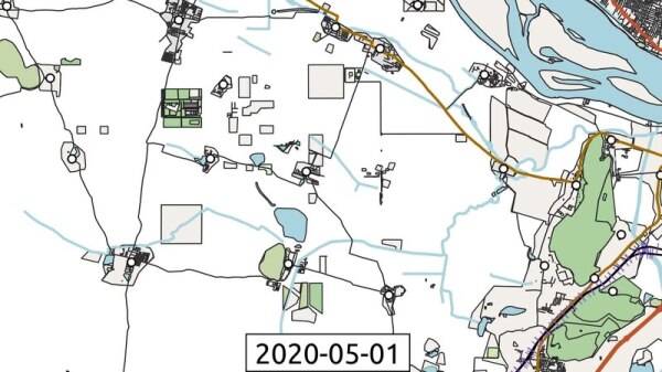
Link to the Time Lapse Video of Amaravati (2015-2025)
My New Year’s resolution is to try not to lose any interest in mapping!
How do I do that?
I don’t know.
What about you guys, what is your New Year’s Resolution related to mapping?
Heppy New Year!
What about you guys, what is your New Years Resolution related to mapping?OpenStreetMap
এই ম্যাপিং কার্যক্রমে কাতিলা মণ্ডলপাড়া জামে মসজিদের তথ্য হালনাগাদ করা হয়েছে। মসজিদটি নাগা বাজার থেকে প্রায় ৫০ মিটার দূরে অবস্থিত। নিকটবর্তী হওয়ার কারণে নাগা বাজারের মুসল্লিরা নিয়মিত পাঁচ ওয়াক্ত নামাজ আদায়ের জন্য এই মসজিদটি ব্যবহার করেন। এই আপডেটে মসজিদের অবস্থানগত প্রেক্ষাপট ও আশপাশের এলাকার সাথে সম্পর্ক যথাযথভাবে উপস্থাপন করা হয়েছে।

নাগা বাজার সংলগ্ন কাতিলা মণ্ডলপাড়া জামে মসজিদের ম্যাপিং আপডেট
এই ম্যাপিং কার্যক্রমে কাতিলা মণ্ডলপাড়া জামে মসজিদের তথ্য হালনাগাদ করা হয়েছে। মসজিদটি নাগা বাজার থেকে প্রায় ৫০ মিটার দূরে অবস্থিত। নিকটবর্তী হওয়ার কারণে নাগা বাজারের মুসল্লিরা নিয়মিত পাঁচ ওয়াক্ত নামাজ আদায়ের জন্য এই মসজিদটি ব্যবহার করেন। এই আপড…OpenStreetMap
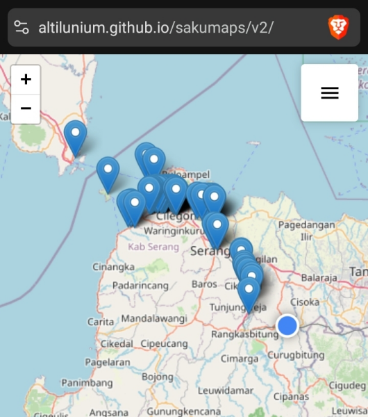
Last weekend I traveled to the west coast of Java, specifically Anyer in Banten. The journey was done by train from Jakarta to Cilegon, followed by a local shared minivan taxi to Anyer.
Hey, this is my first post here and I think it would be fitting if I’d tell all of you why I even created an account here and started making my own edits on OSM.
First, you need to know that I’m a student at Westpomeranian University of Technology in Szczecin in department of computer science. That means that me, and 90% of people there are nerds with interests like: trains, transportation, hacking, programming, opensource and… well… maps.
It all started during a normal day at University. We were walking from one building on campus to another when I noticed that my friend has a map open with a lot of pins and some questions on his phone. I asked him what it is and he told me about “Street Complete”. That’s it! I already knew that my ADHD butt found a new hyperfocus for the indefinite amount of time. I installed it and 3 of us started adding the detail information on the map around our campus.
So… for the next few days I had Street Complete open on my phone during every tram ride and every walk. I wanted to fill every question. This took some time, I answered some question around the Poland in Szczecin, Kielce, and recently in Wałcz.
Right now I’m at my family house in a village where most OSM information where updated several years ago. I went on a walk and - as usual - opened Street Complete. It was great until I came by a few buildings that were demolished few years ago, but were never deleted from the map. I knew that I can’t just leave them there and I couldn’t do this from Street Complete. I went back home and booted my laptop. I opened the OSM editor for the first time and started making edits around the village. Adding houses that were build recently, deleting stuff that no longer existed, updating the zones, etc.
Before I realized I got hooked. It’s so satisfying to make some edits and then see the results. I’ve been making edits everyday for few days ago. I joined community Discord, and learnt quite a few things about how OSM and editor works.
And that’s where we are now… I think I’ll stay here making more edits and updating things that need to be updated. I’ll mainly work on Szczecin and Wałcz, since those are the two places I know the best, but I might make some changes in different places from time to time as well.
Thank you to anyone that read this, I hope you’ll have a great day / night.
Background
First, you need to know that I’m a student at Westpomeranian University of Technology in Szczecin in department of computer science. That means that me, and 90% of people there are nerds with interests like: trains, transportation, hacking, programming, opensource and… well… maps.
How it started?
It all started during a normal day at University. We were walking from one building on campus to another when I noticed that my friend has a map open with a lot of pins and some questions on his phone. I asked him what it is and he told me about “Street Complete”. That’s it! I already knew that my ADHD butt found a new hyperfocus for the indefinite amount of time. I installed it and 3 of us started adding the detail information on the map around our campus.
Street Complete era
So… for the next few days I had Street Complete open on my phone during every tram ride and every walk. I wanted to fill every question. This took some time, I answered some question around the Poland in Szczecin, Kielce, and recently in Wałcz.
Taste for more
Right now I’m at my family house in a village where most OSM information where updated several years ago. I went on a walk and - as usual - opened Street Complete. It was great until I came by a few buildings that were demolished few years ago, but were never deleted from the map. I knew that I can’t just leave them there and I couldn’t do this from Street Complete. I went back home and booted my laptop. I opened the OSM editor for the first time and started making edits around the village. Adding houses that were build recently, deleting stuff that no longer existed, updating the zones, etc.
Before I realized I got hooked. It’s so satisfying to make some edits and then see the results. I’ve been making edits everyday for few days ago. I joined community Discord, and learnt quite a few things about how OSM and editor works.
And that’s where we are now… I think I’ll stay here making more edits and updating things that need to be updated. I’ll mainly work on Szczecin and Wałcz, since those are the two places I know the best, but I might make some changes in different places from time to time as well.
Thank you to anyone that read this, I hope you’ll have a great day / night.

What made me start mapping?
Hey, this is my first post here and I think it would be fitting if Id tell all of you why I even created an account here and started making my own edits on OSM.OpenStreetMap
My diary entries are all my own thoughts and do not represent OpenStreetMap, The Humanitarian OpenStreetMap Team (HOT) or any organisation using the HOT systems. Any errors are all my own work.
I was visiting Sa Pa, Vietnam, and navigating with Organic Maps. I was looking for a street that would bring me back to the city center. I could not see any on OSM or Google Maps. I walked for a while and was able to see a street that led in the right direction. It turns out that it connected to another street that brought me where I wanted to go. This made me realize how much of the useful information in maps depends on people walking, running, or commuting through those streets. You cannot see these kinds of streets from satellite images. You can only know them, but knowing them, you may not use GPS tracking to record them. I think this leaves only runners and anyone who likes walking to discover most of the streets that are not currently on the map.
কাতিলা দারুস সালাম ক্বওমী মাদরাসা রাজশাহী জেলার বাগমারা উপজেলার নিচু কাতিলা এলাকায় অবস্থিত একটি পরিচিত ক্বওমী ধর্মীয় শিক্ষা প্রতিষ্ঠান। মাদরাসাটি নাগা বাজারের উত্তর পাশে অবস্থিত এবং নাগা বাজার থেকে আনুমানিক ১২০০ মিটার দূরত্বে অবস্থান করছে, যা স্থানীয় সড়ক ও পায়ে চলাচলের মাধ্যমে সহজেই পৌঁছানো যায়। প্রতিষ্ঠানটি আশপাশের গ্রামগুলোর শিক্ষার্থী ও ধর্মপ্রাণ মানুষের কাছে সুপরিচিত।
এই ডায়েরি এন্ট্রিতে মাঠ পর্যায়ে যাচাই (ground survey) ও স্থানীয় তথ্যের ভিত্তিতে মাদরাসাটির সঠিক অবস্থান, নাম ও প্রাসঙ্গিক ট্যাগ যাচাই করে OpenStreetMap–এ সংযোজন/হালনাগাদ করা হয়েছে। এর মাধ্যমে নিচু কাতিলা, নাগা বাজার ও পার্শ্ববর্তী এলাকার শিক্ষা প্রতিষ্ঠান সংক্রান্ত ভৌগোলিক তথ্য আরও নির্ভুল ও ব্যবহারযোগ্য হবে বলে আশা করা যায়।
এই ডায়েরি এন্ট্রিতে মাঠ পর্যায়ে যাচাই (ground survey) ও স্থানীয় তথ্যের ভিত্তিতে মাদরাসাটির সঠিক অবস্থান, নাম ও প্রাসঙ্গিক ট্যাগ যাচাই করে OpenStreetMap–এ সংযোজন/হালনাগাদ করা হয়েছে। এর মাধ্যমে নিচু কাতিলা, নাগা বাজার ও পার্শ্ববর্তী এলাকার শিক্ষা প্রতিষ্ঠান সংক্রান্ত ভৌগোলিক তথ্য আরও নির্ভুল ও ব্যবহারযোগ্য হবে বলে আশা করা যায়।

কাতিলা দারুস সালাম ক্বওমী মাদরাসা সংযোজন — নাগা বাজারের উত্তর পাশে (প্রায় ১২০০ মিটার দূরে)
কাতিলা দারুস সালাম ক্বওমী মাদরাসা রাজশাহী জেলার বাগমারা উপজেলার নিচু কাতিলা এলাকায় অবস্থিত একটি পরিচিত ক্বওমী ধর্মীয় শিক্ষা প্রতিষ্ঠান। মাদরাসাটি নাগা বাজারের উত্তর পাশে অবস্থিত এবং নাগা বাজার থেকে আনুমানিক ১২০০ মিটার দূরত্বে অবস্থান করছে, যা স্থান…OpenStreetMap
OSM Apps Catalog Redesign - Survey
Panama Canal Authority–Supported Open Data Initiative
The Los Chorros de Ciri basin, located west of Panama City, is a hydrologically and socially important watershed that supports rural communities while contributing to regional water security. In recognition of this dual importance, the Panama Canal Authority (ACP) funded a high-resolution mapping project focused on community-oriented outcomes and long-term public benefit.
This project represents a shift away from closed, single-purpose GIS deliverables toward open geospatial data that can support community planning, environmental stewardship, and collaborative mapping initiatives.
The mapping effort was designed around the following goals:
Multiple drone missions were conducted in early September 2025, covering discrete but adjacent blocks within the basin. The surveys achieved consistent, high-resolution coverage suitable for both environmental and community-scale mapping.
Key characteristics of the datasets include:
Survey accuracy was evaluated using GPS and 3D error metrics derived during processing. Reported results indicate:
A core outcome of this project was the explicit identification of community features that are often underrepresented in national or commercial datasets. These include:
All derived GIS products from this project were explicitly cleared for public release. This enables their use for:
The Los Chorros de Ciri project demonstrates that professional-grade GIS workflows can serve both institutional needs and community interests. By prioritizing openness and reuse, the project helps ensure that publicly funded geospatial data contributes to shared knowledge, transparency, and long-term community benefit.
Background and Context
The Los Chorros de Ciri basin, located west of Panama City, is a hydrologically and socially important watershed that supports rural communities while contributing to regional water security. In recognition of this dual importance, the Panama Canal Authority (ACP) funded a high-resolution mapping project focused on community-oriented outcomes and long-term public benefit.
This project represents a shift away from closed, single-purpose GIS deliverables toward open geospatial data that can support community planning, environmental stewardship, and collaborative mapping initiatives.
Project Objectives
The mapping effort was designed around the following goals:
- Generate high-accuracy base mapping of the Los Chorros de Ciri basin using drone photogrammetry
- Identify and document community presence within the watershed
- Release derived GIS products for public and open-source use
Data Acquisition and Processing
Drone Photogrammetry Surveys
Multiple drone missions were conducted in early September 2025, covering discrete but adjacent blocks within the basin. The surveys achieved consistent, high-resolution coverage suitable for both environmental and community-scale mapping.
Key characteristics of the datasets include:
- Area coverage exceeding 9 square kilometers across all survey blocks
- Ground sampling distance between 4 and 5 centimeters
- Full image reconstruction for all flights
- Dense point clouds exceeding hundreds of millions of points per block
Accuracy and Quality Control
Survey accuracy was evaluated using GPS and 3D error metrics derived during processing. Reported results indicate:
- Horizontal accuracy (CE90) generally below 0.6 meters
- Vertical accuracy (LE90) generally below 0.7 meters
- Stable reprojection errors and consistent feature reconstruction across blocks
Community Mapping Focus
A core outcome of this project was the explicit identification of community features that are often underrepresented in national or commercial datasets. These include:
- Rural housing clusters
- Informal access roads and footpaths
- Agricultural clearings
- Local watercourses influencing daily life
Open Data and Public Release
All derived GIS products from this project were explicitly cleared for public release. This enables their use for:
- Community mapping and participatory planning
- Integration into open platforms such as OpenStreetMap
- Academic and NGO research
- Watershed management and disaster preparedness
Reflections
The Los Chorros de Ciri project demonstrates that professional-grade GIS workflows can serve both institutional needs and community interests. By prioritizing openness and reuse, the project helps ensure that publicly funded geospatial data contributes to shared knowledge, transparency, and long-term community benefit.
I am proposing a major initiative to ratify and enhance the military fortification data on OpenStreetMap.
কাতিলা সরকারি প্রাথমিক বিদ্যালয় রাজশাহী জেলার বাগমারা উপজেলার কাতিলা গ্রামে অবস্থিত একটি সরকার পরিচালিত প্রাথমিক শিক্ষা প্রতিষ্ঠান। বিদ্যালয়টি নাগা বাজারের নিকটবর্তী হওয়ায় এটি শুধু কাতিলা গ্রামের নয়, আশপাশের এলাকার শিশুদের জন্যও একটি গুরুত্বপূর্…
So it is almost the end of the year, I thought what if I created a summary blog of what I did.
DBSN (DataBase di Sintesi Nazionale) is a database containing the most significant territorial information in Italy. It is developed by IGM (Istituto Geografico Militare) and is available in ODbL, as stated on its website.
I worked on Norse and Orchard in Golden Colorado. The area could use some mapping love.
আজ আমি রাজশাহী জেলার বাগমারা উপজেলার কাতিলা গ্রামে অবস্থিত নাগা বাজার এলাকায় মাঠ পর্যায়ের পর্যবেক্ষণ (field survey) পরিচালনা করি। নাগা বাজার–মৌলভীবিভা সড়ক দিয়ে চলাচলের সময় লক্ষ্য করি যে, প্রধান সড়কের পাশে একটি গ্রামীণফোন সেলুলার টাওয়ার স্থাপিত রয়েছে,…
I am going to make some improvements to the Walla Walla Washington area over the next week. I’ve just found the Rapid editor uses the Microsoft Building Footprint data to suggest features. That’s excellent. Speeds things up significantly.
I am going to make some improvements to the Walla Walla Washington area over the next week. Ive just found the Rapid editor uses the Microsoft Building Footprint data to suggest features. Thats excellent. Speeds things up significantly.
I am going to make some improvements to the Walla Walla Washington area over the next week. Ive just found the Rapid editor uses the Microsoft Building Footprint data to suggest features. Thats excellent. Speeds things up significantly.
I worked on Lloy street today in Portage MI. It could use some mapping love. Streets are there but not much else.
Today while looking at the hand drawn parcel maps that the county provides I learned the creek that runs through my neighborhood has changed it’s name. On the maps it’s called Sulphur Spring Creek. On all the other maps I’ve seen, road signs, and from what we locals call it, it’s just Sulphur Creek. There’s even a nature center / animal rescue that is named for the creek. They don’t use the spring in their name either.

Sulphur (Springs) Creek
Today while looking at the hand drawn parcel maps that the county provides I learned the creek that runs through my neighborhood has changed its name. On the maps its called Sulphur Spring Creek.OpenStreetMap
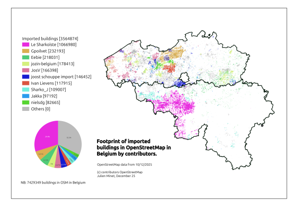
The Belgian OSM community is importing buildings from governmental data into OSM for some years now. In December I was supposed to present a analysis about this process regarding the import of buildings data from the PICC, the source of data for the …
In regards that the tool osm.wikidata.link works best with smaller administerey areas I will break it down on the municipality level(Kommun in Swedish) we have 290 in Sweden.
Hi! Im @likeToTravel, and I suck at writing, so Im gonna go straight to the point:
I´m trying to start a project to learn SPARQL to be able to get on how many of the 63 00 lakes which are in swedish wikipedia/wikidata has their wikidata tag on the OSM element.
Honestly, I have been reading everybody’s diary entries and diving in and looking at all the different areas and detail and I forgot how I even got here! NO idea but I am very intrigued I do not know how much I will have to contribute but I’m determined to figure this all out! I’m fresh meat here amd have never heard of openstreetmap until I landed in the middle of Nigeria very far from home…safe travels and Merry Christmas from Michigan 🇺🇸💋
Love and Light Aphrodite888
Love and Light Aphrodite888

There's No Place Like Home
Honestly, I have been reading everybodys diary entries and diving in and looking at all the different areas and detail and I forgot how I even got here! NO idea but I am very intrigued I do not know how much I will have to contribute but Im determine…OpenStreetMap
I was doing some Unmapped Small Town USA work this evening, and realized that I had tagged a bunch of probable grain silos in other areas as buildings, specifically in Arbela, MO, and Granger, MO, so I’ve gone back in and corrected those to more accurately reflect their purpose. Apologies to Arbela and Granger!
Otherwise, Dover, KY showed up on Unmapped Small Town USA. There’s some great progress already, but still more to do, so I’m taking advantage of some holiday downtime to fill in more buildings.
Otherwise, I hope you have a lovely Christmas Eve, if that is your custom, and a lovely Christmas Day, if that is your custom. If not, I hope you have a very Merry Thursday. :)

Mapmas Day 24: Silo-ence of the Lambs
I was doing some Unmapped Small Town USA work this evening, and realized that I had tagged a bunch of probable grain silos in other areas as buildings, specifically in Arbela, MO, and Granger, MO, so Ive gone back in and corrected those to more accur…OpenStreetMap
নাগা বাজার রাজশাহী জেলার বাগমারা উপজেলার কাতিলা গ্রামের একটি গুরুত্বপূর্ণ বাজার। নাগা বাজার থেকে প্রায় ১৬০০ মিটার দূরে অবস্থিত কাতিলা সবুজ সংঘ হাই স্কুল ও কলেজ, যা স্থানীয় শিক্ষার্থীদের জন্য উচ্চ মাধ্যমিক ও কলেজ পর্যায়ের শিক্ষা প্রদান করে।
বাজার ও স্কুলের ঘনিষ্ঠ অবস্থান এলাকার শিক্ষার সাথে বাণিজ্যিক কার্যক্রমকে সংযুক্ত করে। এই দুই কেন্দ্রের ম্যাপে Node ও Area হিসেবে যোগ করা OSM ব্যবহারকারীদের জন্য এলাকাটিকে সহজে চিহ্নিত ও বোঝার সুযোগ তৈরি করে।
বাজার ও স্কুলের ঘনিষ্ঠ অবস্থান এলাকার শিক্ষার সাথে বাণিজ্যিক কার্যক্রমকে সংযুক্ত করে। এই দুই কেন্দ্রের ম্যাপে Node ও Area হিসেবে যোগ করা OSM ব্যবহারকারীদের জন্য এলাকাটিকে সহজে চিহ্নিত ও বোঝার সুযোগ তৈরি করে।
১৫ নং যোগীপাড়া ইউনিয়ন পরিষদ বাগমারা উপজেলার কাতিলা গ্রামের এলাকায় অবস্থিত। এটি নাগা বাজার থেকে প্রায় ১৫০০ মিটার দূরে অবস্থিত। ইউনিয়ন পরিষদ স্থানীয় প্রশাসনিক কার্যক্রমের কেন্দ্র হিসেবে কাজ করে। এখানে ইউনিয়নের বিভিন্ন সরকারি সেবা, নথি, পরিকল্পনা ও নাগরিক সেবা প্রদান করা হয়। নাগা বাজারের সাথে ঘনিষ্ঠ অবস্থানের কারণে এটি এলাকার মানুষের দৈনন্দিন জীবন ও বাণিজ্যিক কার্যক্রমের জন্য গুরুত্বপূর্ণ।

নাগা বাজারের পার্শ্ববর্তী প্রশাসনিক কেন্দ্র: ১৫ নং যোগীপাড়া ইউনিয়ন পরিষদ
১৫ নং যোগীপাড়া ইউনিয়ন পরিষদ বাগমারা উপজেলার কাতিলা গ্রামের এলাকায় অবস্থিত। এটি নাগা বাজার থেকে প্রায় ১৫০০ মিটার দূরে অবস্থিত। ইউনিয়ন পরিষদ স্থানীয় প্রশাসনিক কার্যক্রমের কেন্দ্র হিসেবে কাজ করে। এখানে ইউনিয়নের বিভিন্ন সরকারি সেবা, নথি, পরিকল্পনা…OpenStreetMap
It is both weird and cool to see the map of my community change in apps I use regularly. Before I started actively updating things in OSM I didn’t recognize all the places OSM is used.
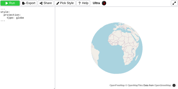
Last November, I [Re]Introduced Ultra v3
which introduced a bunch of new features. Today, Im happy to share whats changed in Ultra over the past year.
which introduced a bunch of new features. Today, Im happy to share whats changed in Ultra over the past year.
As a principle, I’ve always tried to use open-source software over proprietary software for any of my digital needs. I’ve personally found open source to be both more accurate and more sensible to use than proprietary alternatives.
One of the very few aspects of my life that had still not adopted open source was maps. I always used both Waze and Google Maps for everything. But whenever I looked at the maps, it felt like something was missing. I looked around, checked the environment, and realized how much of my surroundings simply wasn’t reflected on the screen.
I wanted to fix it, but… Google Maps doesn’t allow you to just add things. And while Waze does have an editor, it’s extremely locked down for the average user. So, I looked up online alternatives.
I discovered OpenStreetMap two months ago, and I found myself in awe of the sheer amount of detail… Far more than Google Maps or Waze could offer. It just so happened that I was on a trip to Barcelona, and I was using CoMaps to navigate. Using CoMaps proved extremely reliable, especially for public transportation. I never missed a metro, I found all my destinations quickly, and it was very easy to get around.
Still riding the Barcelona high, I opened CoMaps back at home and was fairly shocked to see that my neighborhood didn’t exist at all… Where the heck is it?!
So, I got on my computer, logged into OpenStreetMap for the first time, and started using the iD editor. In just a few hours, the rough outline of my neighborhood was there.
Soon enough, I found myself mapping for hours. Even during lectures, I’d have an OSM tab open for casual mapping. Then it escalated. I started bringing my laptop everywhere I traveled to map things on the go. I began using StreetComplete to add missing metadata. I took pictures and videos. Then I started recording GPS traces. And now I’m even considering setting up a full LiDAR mapping mount for my car…
Now I sit at 16k contributions, with over 400 buildings added. My neighborhood is micro-mapped to hell, and I plan to continue this with the rest of my town.
OpenStreetMap is the best.
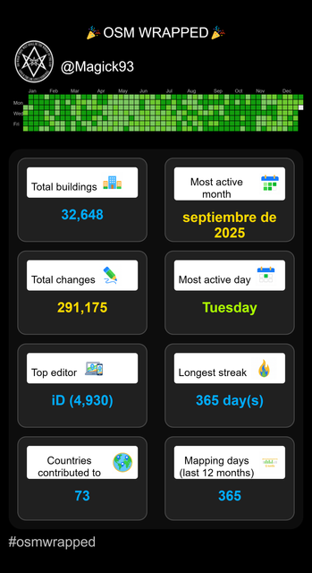
OSMWrapped is a fun tool that visualizes your personal OpenStreetMap (OSM) mapping statistics — including edits made, countries mapped, and active mapping days.
আজ আমি আমার স্থানীয় এলাকা নাগা বাজার OpenStreetMap–এ যুক্ত করেছি। এটি একটি গুরুত্বপূর্ণ স্থান, কারণ নাগা বাজারের আশেপাশের জনগণ দৈনন্দিন জীবনযাপনের জন্য এই স্থানটি ব্যবহার করে।
নাগা বাজারের বিশেষত্ব হলো এটি তিনটি গুরুত্বপূর্ণ সড়কের সংযোগস্থল। এই সড়কগুলো হলো:
নাগা বাজার – মুলিভিটা সড়ক
নাগা বাজার – বীরকুৎসা সড়ক
নাগা বাজার – ভবানিগঞ্জ সড়ক
এই তিনটি সড়ক এলাকার মানুষকে একে অপরের সাথে সহজেই সংযুক্ত করছে এবং স্থানীয় বাণিজ্য ও যোগাযোগে গুরুত্বপূর্ণ ভূমিকা পালন করে। আমি OpenStreetMap–এ নাগা বাজার যুক্ত করার সময় এ সমস্ত সড়ক ও এলাকাসহ বিস্তারিত তথ্য দিয়ে কাজ করেছি।
এটি আমার ব্যক্তিগত ডায়রিতে সংরক্ষণের জন্য একটি গুরুত্বপূর্ণ অর্জন। OpenStreetMap–এ স্থান যুক্ত করার মাধ্যমে স্থানীয়দের জন্য তথ্য সহজলভ্য হবে এবং ভবিষ্যতে মানচিত্র ব্যবহার ও রাস্তাপথ পরিকল্পনায় সহায়ক হবে।
নাগা বাজারের সঠিক স্থান, ল্যাটিটিউড ও লংগিটিউড, এবং সংযুক্ত সড়কগুলো OpenStreetMap–এ উল্লেখ করার মাধ্যমে স্থানটি আরও বেশি কার্যকরভাবে চিহ্নিত হয়েছে। এই কাজ আমার জন্য শিক্ষণীয় এবং এলাকার ডিজিটাল নথিপত্র তৈরিতে সহায়ক হয়েছে।
So, as it turns out, Mapmas is best-effort. ;)
One OSM-related activity I spend lots of time on is micromapping recreational areas, such as parks. Manually detailing out areas is satisfying, but Ive also been on the lookout for ways to put my programming skills to use.
Estonia considers aerial imagery as unconsitutional

Estonia considers aerial imagery as unconsitutional
(Writing a short stub in case i forget it again)OpenStreetMap
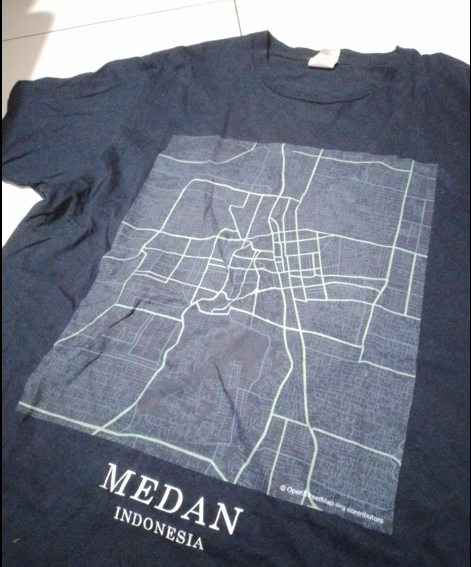
Today, i wear a T-shirt printed with Medan’s road network, based on OpenStreetMap data.
তারিখ: 21.12.2025 স্থান: Naga Bazar, Bagmara, Rajshahi
আজ আমি OpenStreetMap (OSM)-এ “Naga Bazar–Bhobanigonj Road” যুক্ত করেছি। এই সড়কটি নাগা বাজার থেকে ভোবানীগঞ্জ পর্যন্ত বিস্তৃত এবং এলাকার মানুষজন দৈনন্দিন চলাচল, বাজারে যাতায়াত এবং কৃষি পণ্য পরিবহনের জন্য ব্যবহার করে।
আমি সড়কটি OSM-এ যোগ করার সময় ঠিক নাম, অবস্থান এবং রাস্তার ধরন উল্লেখ করেছি। এছাড়া, Description বক্সে সংক্ষিপ্তভাবে লিখেছি সড়কের গুরুত্ব এবং স্থানীয় ব্যবহার। Changeset comment-এ উল্লেখ করেছি যে এটি স্থানীয় সংযোগ রাস্তা।
এই কাজটি করতে গিয়ে বুঝতে পারলাম যে OSM-এ স্থান সংযোজন শুধু মানচিত্রে দেখানোর জন্য নয়, বরং তথ্যকে ডিজিটালভাবে সংরক্ষণ ও বিশ্বের সাথে সংযুক্ত করার একটি মাধ্যম।
আমি আশা করি ভবিষ্যতে আরও রাস্তা, বাজার এবং স্থানীয় এলাকা OSM-এ যোগ করে আমার এলাকার তথ্যসমৃদ্ধ মানচিত্র তৈরি করতে পারব।

OSM-এ নাগা বাজার–ভোবানীগঞ্জ রাস্তা সংযোজন(Newly)
তারিখ: 21.12.2025 স্থান: Naga Bazar, Bagmara, RajshahiOpenStreetMap
