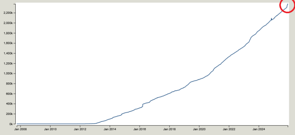
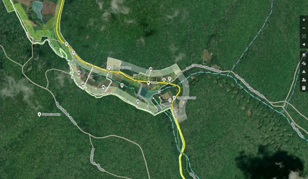
I´m trying to start a project to learn SPARQL to be able to get on how many of the 63 00 lakes which are in swedish wikipedia/wikidata has their wikidata tag on the OSM element.
Honestly, I have been reading everybody’s diary entries and diving in and looking at all the different areas and detail and I forgot how I even got here! NO idea but I am very intrigued I do not know how much I will have to contribute but I’m determined to figure this all out! I’m fresh meat here amd have never heard of openstreetmap until I landed in the middle of Nigeria very far from home…safe travels and Merry Christmas from Michigan 🇺🇸💋
Love and Light Aphrodite888
Love and Light Aphrodite888

There's No Place Like Home
Honestly, I have been reading everybodys diary entries and diving in and looking at all the different areas and detail and I forgot how I even got here! NO idea but I am very intrigued I do not know how much I will have to contribute but Im determine…OpenStreetMap
I was doing some Unmapped Small Town USA work this evening, and realized that I had tagged a bunch of probable grain silos in other areas as buildings, specifically in Arbela, MO, and Granger, MO, so I’ve gone back in and corrected those to more accurately reflect their purpose. Apologies to Arbela and Granger!
Otherwise, Dover, KY showed up on Unmapped Small Town USA. There’s some great progress already, but still more to do, so I’m taking advantage of some holiday downtime to fill in more buildings.
Otherwise, I hope you have a lovely Christmas Eve, if that is your custom, and a lovely Christmas Day, if that is your custom. If not, I hope you have a very Merry Thursday. :)

Mapmas Day 24: Silo-ence of the Lambs
I was doing some Unmapped Small Town USA work this evening, and realized that I had tagged a bunch of probable grain silos in other areas as buildings, specifically in Arbela, MO, and Granger, MO, so Ive gone back in and corrected those to more accur…OpenStreetMap
নাগা বাজার রাজশাহী জেলার বাগমারা উপজেলার কাতিলা গ্রামের একটি গুরুত্বপূর্ণ বাজার। নাগা বাজার থেকে প্রায় ১৬০০ মিটার দূরে অবস্থিত কাতিলা সবুজ সংঘ হাই স্কুল ও কলেজ, যা স্থানীয় শিক্ষার্থীদের জন্য উচ্চ মাধ্যমিক ও কলেজ পর্যায়ের শিক্ষা প্রদান করে।
বাজার ও স্কুলের ঘনিষ্ঠ অবস্থান এলাকার শিক্ষার সাথে বাণিজ্যিক কার্যক্রমকে সংযুক্ত করে। এই দুই কেন্দ্রের ম্যাপে Node ও Area হিসেবে যোগ করা OSM ব্যবহারকারীদের জন্য এলাকাটিকে সহজে চিহ্নিত ও বোঝার সুযোগ তৈরি করে।
বাজার ও স্কুলের ঘনিষ্ঠ অবস্থান এলাকার শিক্ষার সাথে বাণিজ্যিক কার্যক্রমকে সংযুক্ত করে। এই দুই কেন্দ্রের ম্যাপে Node ও Area হিসেবে যোগ করা OSM ব্যবহারকারীদের জন্য এলাকাটিকে সহজে চিহ্নিত ও বোঝার সুযোগ তৈরি করে।
১৫ নং যোগীপাড়া ইউনিয়ন পরিষদ বাগমারা উপজেলার কাতিলা গ্রামের এলাকায় অবস্থিত। এটি নাগা বাজার থেকে প্রায় ১৫০০ মিটার দূরে অবস্থিত। ইউনিয়ন পরিষদ স্থানীয় প্রশাসনিক কার্যক্রমের কেন্দ্র হিসেবে কাজ করে। এখানে ইউনিয়নের বিভিন্ন সরকারি সেবা, নথি, পরিকল্পনা ও নাগরিক সেবা প্রদান করা হয়। নাগা বাজারের সাথে ঘনিষ্ঠ অবস্থানের কারণে এটি এলাকার মানুষের দৈনন্দিন জীবন ও বাণিজ্যিক কার্যক্রমের জন্য গুরুত্বপূর্ণ।

নাগা বাজারের পার্শ্ববর্তী প্রশাসনিক কেন্দ্র: ১৫ নং যোগীপাড়া ইউনিয়ন পরিষদ
১৫ নং যোগীপাড়া ইউনিয়ন পরিষদ বাগমারা উপজেলার কাতিলা গ্রামের এলাকায় অবস্থিত। এটি নাগা বাজার থেকে প্রায় ১৫০০ মিটার দূরে অবস্থিত। ইউনিয়ন পরিষদ স্থানীয় প্রশাসনিক কার্যক্রমের কেন্দ্র হিসেবে কাজ করে। এখানে ইউনিয়নের বিভিন্ন সরকারি সেবা, নথি, পরিকল্পনা…OpenStreetMap
It is both weird and cool to see the map of my community change in apps I use regularly. Before I started actively updating things in OSM I didn’t recognize all the places OSM is used.
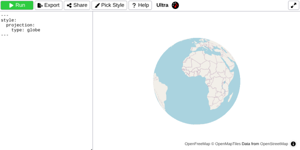
Last November, I [Re]Introduced Ultra v3
which introduced a bunch of new features. Today, Im happy to share whats changed in Ultra over the past year.
which introduced a bunch of new features. Today, Im happy to share whats changed in Ultra over the past year.
As a principle, I’ve always tried to use open-source software over proprietary software for any of my digital needs. I’ve personally found open source to be both more accurate and more sensible to use than proprietary alternatives.
One of the very few aspects of my life that had still not adopted open source was maps. I always used both Waze and Google Maps for everything. But whenever I looked at the maps, it felt like something was missing. I looked around, checked the environment, and realized how much of my surroundings simply wasn’t reflected on the screen.
I wanted to fix it, but… Google Maps doesn’t allow you to just add things. And while Waze does have an editor, it’s extremely locked down for the average user. So, I looked up online alternatives.
I discovered OpenStreetMap two months ago, and I found myself in awe of the sheer amount of detail… Far more than Google Maps or Waze could offer. It just so happened that I was on a trip to Barcelona, and I was using CoMaps to navigate. Using CoMaps proved extremely reliable, especially for public transportation. I never missed a metro, I found all my destinations quickly, and it was very easy to get around.
Still riding the Barcelona high, I opened CoMaps back at home and was fairly shocked to see that my neighborhood didn’t exist at all… Where the heck is it?!
So, I got on my computer, logged into OpenStreetMap for the first time, and started using the iD editor. In just a few hours, the rough outline of my neighborhood was there.
Soon enough, I found myself mapping for hours. Even during lectures, I’d have an OSM tab open for casual mapping. Then it escalated. I started bringing my laptop everywhere I traveled to map things on the go. I began using StreetComplete to add missing metadata. I took pictures and videos. Then I started recording GPS traces. And now I’m even considering setting up a full LiDAR mapping mount for my car…
Now I sit at 16k contributions, with over 400 buildings added. My neighborhood is micro-mapped to hell, and I plan to continue this with the rest of my town.
OpenStreetMap is the best.
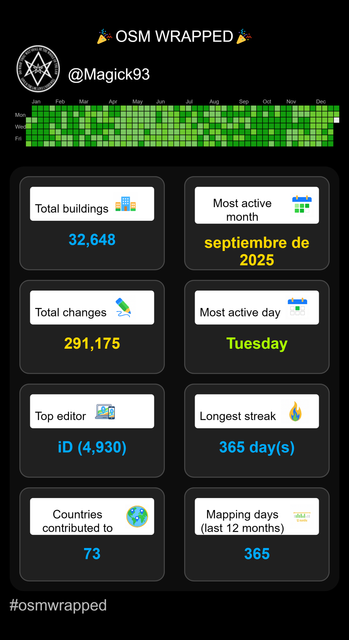
OSMWrapped is a fun tool that visualizes your personal OpenStreetMap (OSM) mapping statistics — including edits made, countries mapped, and active mapping days.
আজ আমি আমার স্থানীয় এলাকা নাগা বাজার OpenStreetMap–এ যুক্ত করেছি। এটি একটি গুরুত্বপূর্ণ স্থান, কারণ নাগা বাজারের আশেপাশের জনগণ দৈনন্দিন জীবনযাপনের জন্য এই স্থানটি ব্যবহার করে।
নাগা বাজারের বিশেষত্ব হলো এটি তিনটি গুরুত্বপূর্ণ সড়কের সংযোগস্থল। এই সড়কগুলো হলো:
নাগা বাজার – মুলিভিটা সড়ক
নাগা বাজার – বীরকুৎসা সড়ক
নাগা বাজার – ভবানিগঞ্জ সড়ক
এই তিনটি সড়ক এলাকার মানুষকে একে অপরের সাথে সহজেই সংযুক্ত করছে এবং স্থানীয় বাণিজ্য ও যোগাযোগে গুরুত্বপূর্ণ ভূমিকা পালন করে। আমি OpenStreetMap–এ নাগা বাজার যুক্ত করার সময় এ সমস্ত সড়ক ও এলাকাসহ বিস্তারিত তথ্য দিয়ে কাজ করেছি।
এটি আমার ব্যক্তিগত ডায়রিতে সংরক্ষণের জন্য একটি গুরুত্বপূর্ণ অর্জন। OpenStreetMap–এ স্থান যুক্ত করার মাধ্যমে স্থানীয়দের জন্য তথ্য সহজলভ্য হবে এবং ভবিষ্যতে মানচিত্র ব্যবহার ও রাস্তাপথ পরিকল্পনায় সহায়ক হবে।
নাগা বাজারের সঠিক স্থান, ল্যাটিটিউড ও লংগিটিউড, এবং সংযুক্ত সড়কগুলো OpenStreetMap–এ উল্লেখ করার মাধ্যমে স্থানটি আরও বেশি কার্যকরভাবে চিহ্নিত হয়েছে। এই কাজ আমার জন্য শিক্ষণীয় এবং এলাকার ডিজিটাল নথিপত্র তৈরিতে সহায়ক হয়েছে।
So, as it turns out, Mapmas is best-effort. ;)
One OSM-related activity I spend lots of time on is micromapping recreational areas, such as parks. Manually detailing out areas is satisfying, but Ive also been on the lookout for ways to put my programming skills to use.
Estonia considers aerial imagery as unconsitutional

Estonia considers aerial imagery as unconsitutional
(Writing a short stub in case i forget it again)OpenStreetMap
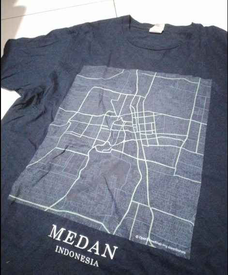
Today, i wear a T-shirt printed with Medan’s road network, based on OpenStreetMap data.
তারিখ: 21.12.2025 স্থান: Naga Bazar, Bagmara, Rajshahi
আজ আমি OpenStreetMap (OSM)-এ “Naga Bazar–Bhobanigonj Road” যুক্ত করেছি। এই সড়কটি নাগা বাজার থেকে ভোবানীগঞ্জ পর্যন্ত বিস্তৃত এবং এলাকার মানুষজন দৈনন্দিন চলাচল, বাজারে যাতায়াত এবং কৃষি পণ্য পরিবহনের জন্য ব্যবহার করে।
আমি সড়কটি OSM-এ যোগ করার সময় ঠিক নাম, অবস্থান এবং রাস্তার ধরন উল্লেখ করেছি। এছাড়া, Description বক্সে সংক্ষিপ্তভাবে লিখেছি সড়কের গুরুত্ব এবং স্থানীয় ব্যবহার। Changeset comment-এ উল্লেখ করেছি যে এটি স্থানীয় সংযোগ রাস্তা।
এই কাজটি করতে গিয়ে বুঝতে পারলাম যে OSM-এ স্থান সংযোজন শুধু মানচিত্রে দেখানোর জন্য নয়, বরং তথ্যকে ডিজিটালভাবে সংরক্ষণ ও বিশ্বের সাথে সংযুক্ত করার একটি মাধ্যম।
আমি আশা করি ভবিষ্যতে আরও রাস্তা, বাজার এবং স্থানীয় এলাকা OSM-এ যোগ করে আমার এলাকার তথ্যসমৃদ্ধ মানচিত্র তৈরি করতে পারব।

OSM-এ নাগা বাজার–ভোবানীগঞ্জ রাস্তা সংযোজন(Newly)
তারিখ: 21.12.2025 স্থান: Naga Bazar, Bagmara, RajshahiOpenStreetMap
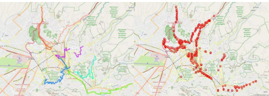
Mapping and data optimization of routes and stops of the PumaKatari municipal transport, nearby pedestrian and cycling routes, in the city of La Paz, Bolivia
Over the past year, I made a lot of contributions to Reginas OSM. Since snow has made surveying difficult, I felt a retrospective on those contributions were a good idea.
In the ancient days, OSM was much simpler. You had the streets and roads.
A crossing was considered a barrier along the way for road users (i.e. cars), so one would place a node with where the crosswalk is located.
A crossing was considered a barrier along the way for road users (i.e. cars), so one would place a node with where the crosswalk is located.
COLLABORATIVE MAPPING VOLUNTEERING AT THE SENDA VERDE WILDLIFE SANCTUARY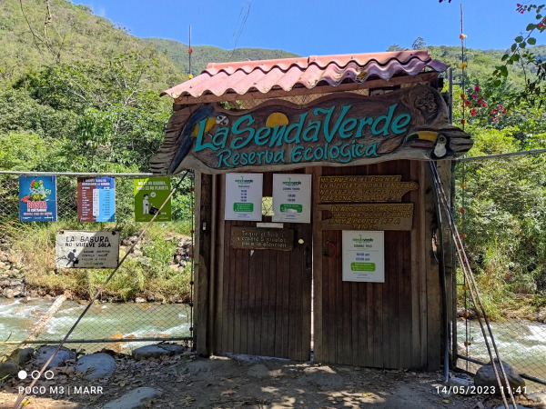

COLLABORATIVE MAPPING VOLUNTEERING AT THE SENDA VERDE WILDLIFE SANCTUARY
Place: Nor Yungas, Yolosa, Bolivia – Senda Verde Animal ShelterOpenStreetMap
রাজশাহী জেলার বাগমারা উপজেলার যোগীপাড়া ইউনিয়নের কাতিলা গ্রামে অবস্থিত নাগা বাজার–মুলিভিটা সংযোগ সড়কটি মাঠপর্যায়ের তথ্য ও স্থানীয় জ্ঞানের ভিত্তিতে মানচিত্রে সংযোজন করা হয়েছে।
আজ আমি OpenStreetMap-এ নাগা বাজার এলাকায় “Naga Vila” নামে একটি আবাসিক বাড়ি যোগ করেছি।
লোকাল জ্ঞানের ভিত্তিতে building=house ট্যাগ ব্যবহার করে পয়েন্ট হিসেবে ম্যাপ করা হয়েছে।এতে এলাকার আবাসিক ম্যাপিং আরও সঠিক হবে।
লোকাল জ্ঞানের ভিত্তিতে building=house ট্যাগ ব্যবহার করে পয়েন্ট হিসেবে ম্যাপ করা হয়েছে।এতে এলাকার আবাসিক ম্যাপিং আরও সঠিক হবে।
Last night, I added Arbela, MO, and some geometry in the immediate vicinity. It’s the next village west of Granger, MO.
Today, I did a quick walk for a GPS trace, and then I came home and added some more geometry around Arbela. Unfortunately, I managed to get JOSM into a bad state before uploading, and I decided to start this evening’s changes over again. Alas. It’s almost bedtime, but I was able to redo the buildings and the driveways I’d done before. The water will have to wait until tomorrow.
Merry Mapmas!

Mapmas Day 16 - Arbela, MO
Last night, I added Arbela, MO, and some geometry in the immediate vicinity. Its the next village west of Granger, MO.OpenStreetMap
আজ OpenStreetMap-এ আমার একটি নতুন অবদান যোগ করেছি। নাগা বাজার এলাকায় অবস্থিত “Naga Bazar Shopping and Service Centre” মানচিত্রে যুক্ত করা হয়েছে। এই স্থাপনাটি স্থানীয়ভাবে পরিচিত একটি শপিং ও সেবা কেন্দ্র, যা আগে মানচিত্রে উল্লেখিত ছিল না।
এই তথ্যটি আমি স্থানীয় জ্ঞান ও পর্যবেক্ষণের ভিত্তিতে যোগ করেছি এবং ভবিষ্যতে আশপাশের অন্যান্য গুরুত্বপূর্ণ স্থান ও সড়কের তথ্য যাচাই করে ধাপে ধাপে যুক্ত করার পরিকল্পনা রয়েছে। অভিজ্ঞ ম্যাপারদের যেকোনো পরামর্শ বা সংশোধনকে স্বাগত জানাই।
এই তথ্যটি আমি স্থানীয় জ্ঞান ও পর্যবেক্ষণের ভিত্তিতে যোগ করেছি এবং ভবিষ্যতে আশপাশের অন্যান্য গুরুত্বপূর্ণ স্থান ও সড়কের তথ্য যাচাই করে ধাপে ধাপে যুক্ত করার পরিকল্পনা রয়েছে। অভিজ্ঞ ম্যাপারদের যেকোনো পরামর্শ বা সংশোধনকে স্বাগত জানাই।
Unsure about Cottage Grove Rd. Should i put the source:hgv tags or not? signs on left and far right Source list - ordinances - can’t find anything
We havent had a London pub meet-up in a while. I probably couldve organised something, but got waylaid by Dundee, and preparing a talk for Dundee, and recovering from all the excitement of Dundee.
Im kicking myself for not celebrating Mapmas, since I apparently signed up on December 1st. :) Alas.
Recently, I started adding a large number of roof:colour tags to buildings that had previously lacked this information. I started in Colorado Springs for no particular reason, but I plan to expand this activity further.
Bell Island, Newfoundland has now been practically fully mapped. There were some features that I was not able to fully map since it would have required local knowledge, however I’m happy with the extent of what was able to be mapped based off of satellite imagery alone.
With some reflection I think the scope of this project was quite large but still manageable since I didn’t put any strict timelines on myself. In the future I’ll likely choose slightly smaller scale projects where the whole thing can be wrapped up within a couple of months. In the interim I’ll probably map some of the smaller islets around Conception Bay.
With some reflection I think the scope of this project was quite large but still manageable since I didn’t put any strict timelines on myself. In the future I’ll likely choose slightly smaller scale projects where the whole thing can be wrapped up within a couple of months. In the interim I’ll probably map some of the smaller islets around Conception Bay.

Mapping Bell Island #3: Conclusion
Bell Island, Newfoundland has now been practically fully mapped. There were some features that I was not able to fully map since it would have required local knowledge, however Im happy with the extent of what was able to be mapped based off of satel…OpenStreetMap
Today is the first day of the AFRIGIST Alumni OSM TRAINING program. I serve as the assistance surveyor of the Redeemed Christiane Church of God
Today is the 1st day of AFRIGIST Alumni training,engaging in OpenStreeMap practical. I served as resource person along side with Unique Mappers
Today is the 1st day of AFRIGIST Alumni training,engaging in OpenStreeMap practical.
I served as resource person along side with Unique Mappers
Today is the 1st day of AFRIGIST Alumni training,engaging in OpenStreeMap practical.
I served as resource person along side with Unique Mappers

AFRIGIST Alumni Network -Training workshop in OSM supported by Unique Mappers Nigeria
Today is the 1st day of AFRIGIST Alumni training,engaging in OpenStreeMap practical. I served as resource person along side with Unique MappersOpenStreetMap
It was a nice day. I think I just added more cameras. I also saw several cats, and a very excited dog who ran over to the fence to jump up and say hi. A nice day, indeed.
I also noticed that one of the house numbers on the north side of E Culver Ave seems to be out of order with the rest. The house numbers go: 537, 543, 555, 605, 569, 577. 605 is between 555 and 569, which doesn’t make sense. 618 is across the street, and starts the even-numbered 600 houses. Was it meant to maybe be 565 and some clerical error happened? Is it even a mistake at all or is this something deliberate? I have no idea, but it definitely threw me. I wonder if they struggle to receive packages.
I also noticed that one of the house numbers on the north side of E Culver Ave seems to be out of order with the rest. The house numbers go: 537, 543, 555, 605, 569, 577. 605 is between 555 and 569, which doesn’t make sense. 618 is across the street, and starts the even-numbered 600 houses. Was it meant to maybe be 565 and some clerical error happened? Is it even a mistake at all or is this something deliberate? I have no idea, but it definitely threw me. I wonder if they struggle to receive packages.
I have to mapping projects I’m doing here. The first one, the one that has most of my focus is my home community of Fairview, California. The other is Canonsburg, Pennsylvania. For both projects I rely on a variety of tools:
- the Bing visual
- Google maps
- County GIS records

Finding errors on Google Maps
I have to mapping projects Im doing here. The first one, the one that has most of my focus is my home community of Fairview, California. The other is Canonsburg, Pennsylvania. For both projects I rely on a variety of tools:OpenStreetMap
A few kilometers from the town of Luncavița in Tulcea County, tourists visiting the Măcin Mountains National Park can stop off in Cetățuia hamlet — a paradise for beekeepers who have brought bees to the linden forests (that define this hamlet) and fo…
নাগা বাজার — বীরকুৎসা সড়ক আমাদের দেখায় কীভাবে একটি ছোট স্থানীয় পথ থেকে বৃহৎ পরিবর্তন ও উন্নয়নের সম্ভাবনা তৈরি হতে পারে। এটি কেবল পথ নয়—এখানে মানুষের জীবিকা, সংস্কৃতি, অর্থনীতি ও দৈনন্দিন জীবনের রক্ষাকবচ লুকিয়ে আছে। সঠিক পরিকল্পনা, স্থায়ী রক্ষণাবেক্ষণ, স্থানীয় অংশগ্রহণ ও পরিবেশের সঙ্গে সমন্বয় রেখে উন্নয়ন করলে এই ৩ কিলোমিটার পথ পুরো এলাকাকে নতুনভাবে সংজ্ঞায়িত করতে পারে। রাষ্ট্রীয় তহবিল, স্থানীয় সরকার ও গৃহস্থালি উদ্যোগ মিলিয়ে এই সড়কটিকে শুধু চলার পথ না রেখে একটি স্থায়ী উন্নয়নের কাঁচা-সহজ রিংক হিসেবে গড়ে তোলা যেতে পারে—যা আগামী প্রজন্মের জন্য উন্নত সুযোগ ও জীবিকা তৈরি করবে।

ওপেনস্ট্রিটম্যাপে নাগা বাজার-বীরকুটশা রাস্তার পয়েন্ট যোগ।
নাগা বাজার — বীরকুৎসা সড়ক আমাদের দেখায় কীভাবে একটি ছোট স্থানীয় পথ থেকে বৃহৎ পরিবর্তন ও উন্নয়নের সম্ভাবনা তৈরি হতে পারে। এটি কেবল পথ নয়—এখানে মানুষের জীবিকা, সংস্কৃতি, অর্থনীতি ও দৈনন্দিন জীবনের রক্ষাকবচ লুকিয়ে আছে। সঠিক পরিকল্পনা, স্থায়ী রক্ষণ…OpenStreetMap
Orange is pleasant to walk around. The houses are unique and interesting, the people are friendly, and sometimes there are dogs outside you can say hi to (and I say hi to every single one). Even in the quieter neighborhoods, its still a lively place.
Headings
# Heading
## Subheading
Unordered list
* First item
* Second item
Ordered list
1. First item
2. Second item
Link
Text
Image
Code block
~~~
Code block
# Heading
## Subheading
Unordered list
* First item
* Second item
Ordered list
1. First item
2. Second item
Link
Text
Image
Code block
~~~
Code block
New Diary Entry
Headings # Heading ## Subheading Unordered list * First item * Second item Ordered list 1. First item 2. Second item Link Text Image Code block ~~~ Code blockOpenStreetMap
gpx desa terdampak
PDF Ukuran Kertas A-0
Google view
PDF Ukuran Kertas A-0
Google view
Current wiki guidance for tagging slipways (https://wiki.openstreetmap.org/wiki/Tag:leisure=slipway) is as follows:

Slipways
Current wiki guidance for tagging slipways (https://wiki.openstreetmap.org/wiki/Tag:leisure=slipway) is as follows:OpenStreetMap
