How dare you cast aspersions on and try to obstruct me and my work on OpenStreetMap in Victoria, BC. I thought OpenStreetMap was supposed to be collaborative, but instead you proceed to misrepresent my statements and get openly hostile and destructive toward my efforts. Now I must demand that you cease all further interference with and circumvention of what I am trying to do. I will not have it.
To user "Proud-Suspect-5237" on Reddit
How dare you cast aspersions on and try to obstruct me and my work on OpenStreetMap in Victoria, BC. I thought OpenStreetMap was supposed to be collaborative, but instead you proceed to misrepresent my statements and get openly hostile and destructi…OpenStreetMap

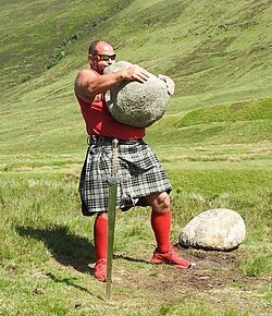
For quite a while now, I have been thinking about making a tutorial on mapping lifting stones. In case you are not familiar - this is a tradition throughout parts of Europe (VERY strong in the Basque country), but also in Asia and North America.
Earlier this month my husband and I drove by or through a number of small communities in Northern California as we were headed to and from Canada. One of them was Grenada. I was curious to see if it was mapped on OSM. It wasn’t, save for the streets (including some erroneously added ones).
So I’ve spent my mapping time this month on Grenada. And now the buildings and addresses are there.
So I’ve spent my mapping time this month on Grenada. And now the buildings and addresses are there.
We all gave OpenStreetMap a try once, no? Same for me. No idea how old my (old) account is. I havent used it for years, and I wasnt able to re-enable it again but in Autumn 2024, a friend told me about StreetComplete.
Problem with foot=no on lawfully forbidden streets(Train-Crossing). not verifiable on the Ground
Problem with foot=no on lawfully forbidden streets(Train-Crossing). not verifiable on the Ground
Hello, just a collection before putting it into a purposalOpenStreetMap
Easy way to find Speed Limit data for Motorways (Highways), Trunk roads, and Primary roads in United States of America
Easy way to find Speed Limit data for Motorways (Highways), Trunk roads, and Primary roads in United States of America
I live in Washington State and noticed that several main roads like state highways did not have a speed limit set.OpenStreetMap
I grew up in Nepal. Hills everywhere. Roads that don’t exist on any map. Communities that satellites can barely see through the cloud cover. When I first heard about OpenStreetMap, I thought: this is exactly what those places need.
That was a few years ago. Since then I’ve spent over 300 hours mapping, not because someone paid me to, but because I kept thinking about the person who might one day need that road to exist on a map before they could get help.
How I Started: Before I knew what OSM was, I was already messing around with maps, visiting new places, uploading photos to Google Maps, adding names, leaving notes about locations. I liked documenting places. That habit slowly turned into something bigger.
A hackathon in college introduced me to humanitarian mapping. That’s when it clicked: mapping wasn’t just a tech thing. It was about making communities visible.
My background is electrical engineering. My job is in the cable car sector. Neither screams “mapper.” But when you work in mountain infrastructure, you see how much depends on accurate geographic data, withdrawal routes, access to remote villages, disaster response. The gap between what exists on the ground and what exists on a map is sometimes jarring.
I’ve actually validated more tasks on HOT than I’ve mapped myself, which felt strange at first. But validation matters as much as mapping, maybe more. A wrong building polygon in a flood response map doesn’t help anyone.
On Women and Mapping: Most mapping events I’ve attended, online or in-person, are heavily male. So is the leadership in local OSM chapters. But whenever a woman shows up and starts contributing, the quality is often excellent. Careful, methodical, detail-oriented. And then they disappear. Not because they lost interest, usually because no one made space for them to stay.
OpenHerMap changed something about that. I watched women across the Asia Pacific region build their own mapping networks, train each other, and take on projects the broader HOT community ended up relying on.
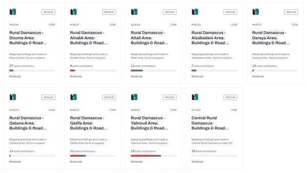
I think about the Nepal Red Cross Missing Maps project, 65 tasks covering Bhajani Municipality. Remote, underserved, barely visible on any mainstream map. The communities there include women who walk hours to reach health clinics, children who cross unmapped rivers to get to school. When those paths get mapped, it’s not abstract. It’s someone getting somewhere safely.
What Mapping Taught Me That Engineering Didn,t: Engineering taught me precision. OSM taught me that precision without inclusion is incomplete.
A map built only by people who look like me, engineers, men, people with reliable internet, will have gaps. Not intentional ones. Just the natural result of mapping what you can see and know. Women map differently, not because of some essential quality, but because their daily routes, their safety concerns, their infrastructure needs are different. A market that women use every morning may not appear on a map if no woman was ever asked to trace it.
I tend toward roads and buildings because that’s what humanitarian projects prioritize. But POIs, shops, health posts, water sources, safe gathering points, that’s where local knowledge matters most, and local women often hold that knowledge.
Where I Am Now: Today I’m an Advanced Mapper on HOT with over 300 hours of contribution. I still work in the cable car sector. The mapping happens in the margins, evenings, weekends, lunch breaks.
The theme of this competition is “Women and Mapping in OSM.” I’m a man writing about it. That might seem odd. But this isn’t only women’s work to do. Making open mapping more inclusive requires everyone to notice the gaps and then do something about them.
The map is never finished. That’s the point.
Pradip Subedi, Nepal, HOT Mapper, OpenStreetMap Contributor.
That was a few years ago. Since then I’ve spent over 300 hours mapping, not because someone paid me to, but because I kept thinking about the person who might one day need that road to exist on a map before they could get help.
How I Started: Before I knew what OSM was, I was already messing around with maps, visiting new places, uploading photos to Google Maps, adding names, leaving notes about locations. I liked documenting places. That habit slowly turned into something bigger.
A hackathon in college introduced me to humanitarian mapping. That’s when it clicked: mapping wasn’t just a tech thing. It was about making communities visible.
My background is electrical engineering. My job is in the cable car sector. Neither screams “mapper.” But when you work in mountain infrastructure, you see how much depends on accurate geographic data, withdrawal routes, access to remote villages, disaster response. The gap between what exists on the ground and what exists on a map is sometimes jarring.
I’ve actually validated more tasks on HOT than I’ve mapped myself, which felt strange at first. But validation matters as much as mapping, maybe more. A wrong building polygon in a flood response map doesn’t help anyone.
On Women and Mapping: Most mapping events I’ve attended, online or in-person, are heavily male. So is the leadership in local OSM chapters. But whenever a woman shows up and starts contributing, the quality is often excellent. Careful, methodical, detail-oriented. And then they disappear. Not because they lost interest, usually because no one made space for them to stay.
OpenHerMap changed something about that. I watched women across the Asia Pacific region build their own mapping networks, train each other, and take on projects the broader HOT community ended up relying on.
I think about the Nepal Red Cross Missing Maps project, 65 tasks covering Bhajani Municipality. Remote, underserved, barely visible on any mainstream map. The communities there include women who walk hours to reach health clinics, children who cross unmapped rivers to get to school. When those paths get mapped, it’s not abstract. It’s someone getting somewhere safely.
What Mapping Taught Me That Engineering Didn,t: Engineering taught me precision. OSM taught me that precision without inclusion is incomplete.
A map built only by people who look like me, engineers, men, people with reliable internet, will have gaps. Not intentional ones. Just the natural result of mapping what you can see and know. Women map differently, not because of some essential quality, but because their daily routes, their safety concerns, their infrastructure needs are different. A market that women use every morning may not appear on a map if no woman was ever asked to trace it.
I tend toward roads and buildings because that’s what humanitarian projects prioritize. But POIs, shops, health posts, water sources, safe gathering points, that’s where local knowledge matters most, and local women often hold that knowledge.
Where I Am Now: Today I’m an Advanced Mapper on HOT with over 300 hours of contribution. I still work in the cable car sector. The mapping happens in the margins, evenings, weekends, lunch breaks.
The theme of this competition is “Women and Mapping in OSM.” I’m a man writing about it. That might seem odd. But this isn’t only women’s work to do. Making open mapping more inclusive requires everyone to notice the gaps and then do something about them.
The map is never finished. That’s the point.
Pradip Subedi, Nepal, HOT Mapper, OpenStreetMap Contributor.
From the Hills of Nepal to the World: My Story in Open Mapping
I grew up in Nepal. Hills everywhere. Roads that dont exist on any map. Communities that satellites can barely see through the cloud cover. When I first heard about OpenStreetMap, I thought: this is exactly what those places need.OpenStreetMap
Just after the midnight of May 21 to May 22, 2026 the 5000th daily planet diff was generated.
- So I finally modified the boundary of Palo, Leyte, where Barangay Barayong is part of it. I was first putting a note to let anyone edit or find the boundary source from the local government, until I decided to do it myself. Not official, by the way.

Tonight I finished mapping every building, every address in Farley Iowa. There are still buildings and farms outside the city limits but that’s a future project.
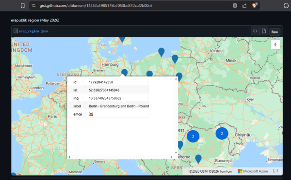
While preparing this article, I wanted to export the coordinate data of the battlefield map that I created in Altilunium LocationPad to GitHub Gist.
Hi bestie, I love you so much for being a strong girl. You are strong You are beautiful You are dligent You are intelligent You are smart You are loved Continue being good and never stop being you.
Hi bestie, I love you so much for being a strong girl.
You are strong
You are beautiful
You are dligent
You are intelligent
You are smart
You are loved
Continue being good and never stop being you.
Hi bestie, I love you so much for being a strong girl.
You are strong
You are beautiful
You are dligent
You are intelligent
You are smart
You are loved
Continue being good and never stop being you.
My Beautiful Journey #zahis #journey #iamzaynab
Hi bestie, I love you so much for being a strong girl. You are strong You are beautiful You are dligent You are intelligent You are smart You are loved Continue being good and never stop being you.OpenStreetMap
Hi,
I am Venetis, a computer science student from Thessaloniki. This summer Ill be working on
closures.osm.ch as part of Google Summer of Code 2026, mentored by Simon Poole and David Haberthür.
I am Venetis, a computer science student from Thessaloniki. This summer Ill be working on
closures.osm.ch as part of Google Summer of Code 2026, mentored by Simon Poole and David Haberthür.
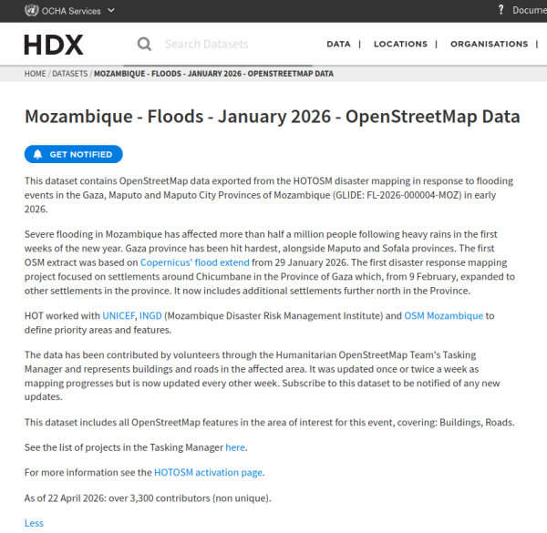
For the first time, Humanitarian Data Exchange (HDX), a widely used platform for sharing humanitarian data, is releasing disaster-specific OSM datasets.
Issue #1 when first using offline OpenStreetMap navigation apps for Android, such as OsmAnd, Comaps, and Organic Maps: the size of the map to be downloaded. In many places, it’s the entire country or nothing.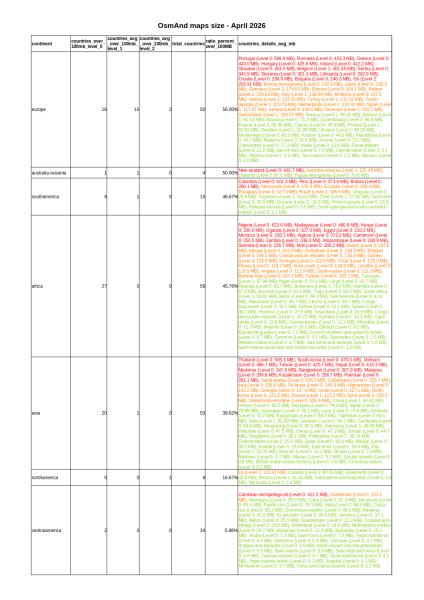
Current Limitations of OpenStreetMap Smartphone Apps – First Post
Issue #1 when first using offline OpenStreetMap navigation apps for Android, such as OsmAnd, Comaps, and Organic Maps: the size of the map to be downloaded. In many places, it’s the entire country or nothing.OpenStreetMap
30x30 (https://en.wikipedia.org/wiki/30_by_30) is a global initiative proposed in the Kunming-Montreal Global Biodiversity Framework to conserve 30% of the area represented by Earths land, water and oceans.
30x30
30x30 (https://en.wikipedia.org/wiki/30_by_30) is a global initiative proposed in the Kunming-Montreal Global Biodiversity Framework to conserve 30% of the area represented by Earths land, water and oceans.OpenStreetMap
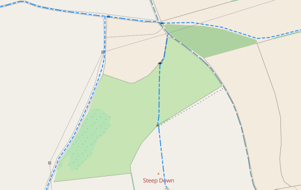
Over the last few weeks Ive improved the way that paths and tracks are shown on map.atownsend.org.uk in both the raster and vector versions. The aims were:
Contributing commercial vehicle GPS traces from Kerala — a routing approach
I’ve been working on a method to convert commercial vehicle telematics data into useful GPX traces for OSM contribution in Kerala.
The problem
Telematics data is segment-based — each record has a start coordinate, end coordinate, timestamp and distance, but no continuous GPS track in between. Uploading these directly produces straight lines which aren’t useful for mapping.
The solution
I set up a local OSRM instance using the Kerala road extract from Geofabrik, then route-matched each segment to the actual road network. This produces GPX traces with thousands of road-following points instead of straight lines.
Results
From two months of data covering Thrissur, Irinjalakuda, Chalakudy, Kodungallur and surrounding areas:
- 141 road-snapped segments uploaded as GPX traces
- 19 high-priority segments flagged as possible unmapped roads
- These will be cross-checked against aerial imagery in JOSM
Next steps
Reviewing the unmapped road candidates in JOSM against Bing aerial imagery. More vehicle data from the same region will be processed and contributed regularly.
If anyone in the Kerala OSM community has experience with similar data or wants to collaborate on reviewing unmapped road candidates, feel free to reach out.
Tools used: Python, OSRM (self-hosted), gpxpy
Contributing commercial vehicle GPS traces from Kerala — a routing approach
Ive been working on a method to convert commercial vehicle telematics data into useful GPX traces for OSM contribution in Kerala.OpenStreetMap
A special opportunity: presenting OpenStreetMap to the Pedagogical University of Maputo (Mozambique)
Yesterday I cleaned up some map data by removing unnecessary email and unrelated details from several objects. I am learning and trying to follow proper OpenStreetMap mapping guidelines.
[This is a work in progress, IANAL and this isnt legal advice]
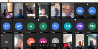
My name is Chukwuemeka Emmanuel Nwosu, a 300-level student of the Department of Geography and Environmental Management, University of Port Harcourt. This diary documents my Industrial Training (I.T.) programme as I undergo it.
After careful thought, deliberation, and counsel from my mentor and my brother, I decided to carry out my I.T. programme at the Mapathon Center of the Unique Mappers Team, University of Port Harcourt. I officially resumed on Tuesday, the 11th of May 2026.
On my first day at the Mapathon Center, I had the pleasure of meeting several interesting individuals who, like me, were present for their Industrial Training. Among them were Matel, who serves as our I.T. representative, and Wisdom, both students from the Department of Geology, Rivers State University, and two of my coursemates from the Department of Geography and Environmental Management: Rania and Obasi Emmanuel. I also learned of a few other trainees I had yet to meet in person.
Notably, I was able to complete a part of the week’s assigned task on this very first day. The task required me to create a map of the University of Port Harcourt, situating it within the context of Rivers State and Nigeria as a whole, while clearly indicating the locations of Abuja Park and Delta Park within the university.
After careful thought, deliberation, and counsel from my mentor and my brother, I decided to carry out my I.T. programme at the Mapathon Center of the Unique Mappers Team, University of Port Harcourt. I officially resumed on Tuesday, the 11th of May 2026.
On my first day at the Mapathon Center, I had the pleasure of meeting several interesting individuals who, like me, were present for their Industrial Training. Among them were Matel, who serves as our I.T. representative, and Wisdom, both students from the Department of Geology, Rivers State University, and two of my coursemates from the Department of Geography and Environmental Management: Rania and Obasi Emmanuel. I also learned of a few other trainees I had yet to meet in person.
Notably, I was able to complete a part of the week’s assigned task on this very first day. The task required me to create a map of the University of Port Harcourt, situating it within the context of Rivers State and Nigeria as a whole, while clearly indicating the locations of Abuja Park and Delta Park within the university.
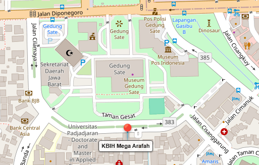
On the quiet early morning of 18 July 2018, pilgrims from the Mega Arafah Hajj Guidance Group (KBIH Mega Arafah) gathered at the Mega Arafah office near Gedung Sate.
Fillet Tools: a small JOSM plugin for rounding corners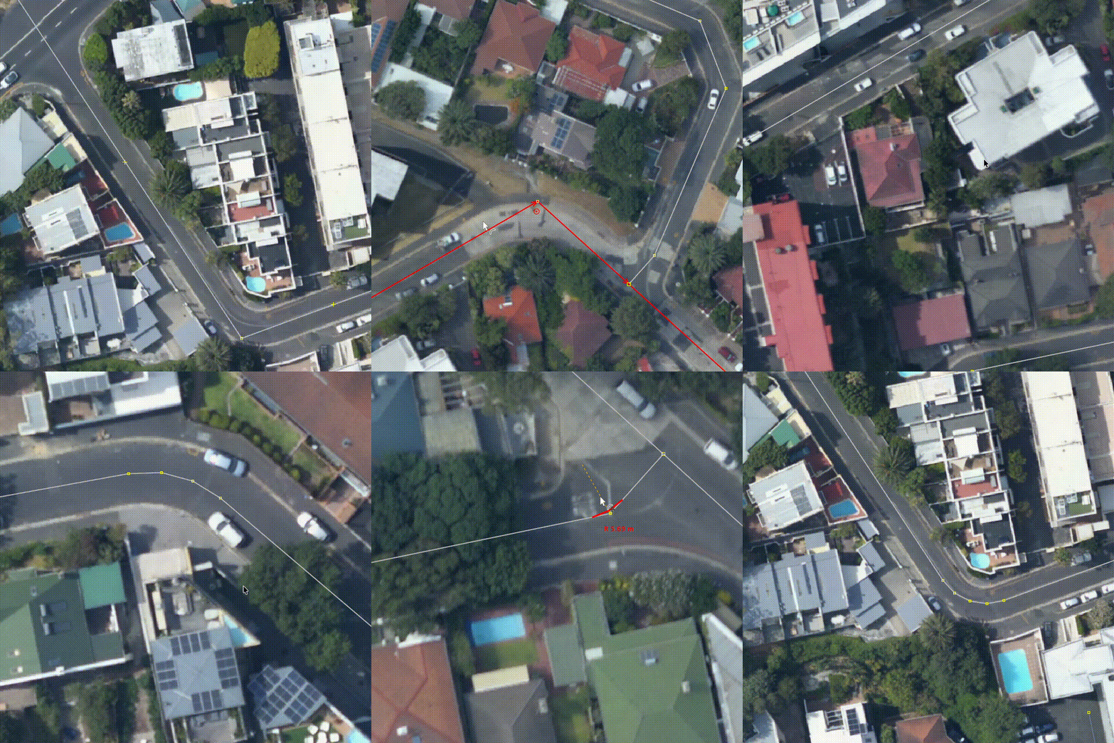
Fillet Tools: a small JOSM plugin for rounding corners
I made a small JOSM plugin called Fillet Tools ().OpenStreetMap
Tornadoes are very complex natural disasters involving many shapes and sizes. For a tornado to be on the ground, Look for rotating dust on the ground. The funnel does
## NOT
have to touch the ground to be considered a tornado.
## NOT
have to touch the ground to be considered a tornado.
Hiking has become a popular choice for many outdoor enthusiasts. Especially since the spread of COVID in the early 2020s, hiking has gained widespread popularity.
Twin Ports Warehouse & Storage
I got into looking into maps and understanding where everything is. I’m at the point where if I’m at a location I’ve never been before, I will start looking all around me and then using my brain to put everything into OpenStreetMap. I love this website. It’s like a passion project when nothing else sounds fun. Anyway… The point of this Diary is all the changes I added to different locations around the northern parts of Minnesota and Wisconsin. Here is what I wanted to update users past and present on what changes I made.
– 05/09/2026 – Location: 46°44’03.6”N 92°04’46.8”W
I want to thank the community for not deleting @MidwestMapGeek’s building outline. Today, I came here to fix what is the updated version. My goal is to help Semi Drivers and anyone trying to get to this company’s site. You are amazing @MidwestMapGeek

- Used Bing Maps Aerial to redraw buildings
– Changeset Number: 182447332 –
5/09/2026
I got into looking into maps and understanding where everything is. Im at the point where if Im at a location Ive never been before, I will start looking all around me and then using my brain to put everything into OpenStreetMap. I love this website.OpenStreetMap
Generally speaking, Lifecycle Prefixes mean that when something is no longer in use, a tag such as gets changed to . That should be straightforward, but sometimes creeps in.
Welcome to my first entry in OSM.
I have been quite interested in being here every once in a while, it actually helps the fact that there’s a map that needs constant updating and can actually do something.
So far, from what I’ve done within my local city of London, Ontario, I finished up:
- New Plaza at Fanshawe/Highbury
- Bus routes
- Road classification
- Fixing of OSM notes
- Coveted new developments at the South and West sides of the city.
How to clear an entire city of unfixed notes and outdated places?
I have been quite interested in being here every once in a while, it actually helps the fact that theres a map that needs constant updating and can actually do something.OpenStreetMap
Silos. Map ‘em. As many as you can. Lovely round, tall silos. Almost never singular. Search for them in farmyards, along railroads. Bonus points for mapping the elevator, truck scales, other assorted buildings and even adding operator.
I love OSM being first. So I went straight out to take GPS trace of new roundabout on our towns bypass, almost as soon as bypass re-opened.
Today marks three years since I joined the OpenStreetMap community in May 2023. I am posting this diary entry at the exact time I published my first changeset, which I still remember clearly for its simple message: “add more data.”
It’s a straightforward phrase, but over these three years, it’s really shaped my journey as a mapper. What began as a tiny contribution has blossomed into a deep commitment to mapping my area in as much detail as possible.
Right now, I’m focused on two main goals for our region:
There’s a lot to tackle, but as I’ve realized over these three years, the best way to map a country is one node at a time. The upcoming changesets will make OpenStreetMap one of the most accurate maps of Tulcea, providing a level of detail that other commercial map services simply cannot match. I can’t wait to see the map evolve even further.
It’s a straightforward phrase, but over these three years, it’s really shaped my journey as a mapper. What began as a tiny contribution has blossomed into a deep commitment to mapping my area in as much detail as possible.
Main Objectives
Right now, I’m focused on two main goals for our region:
Power Grid: I’m mapping every single power line in Tulcea County, from the high voltage transmission lines to the medium and low voltage lines which provide power to every town and village.
Improving Every Town: Besides the infrastructure, I aim to enhance the data for every town in Tulcea County. This involves cleaning up geometry, adding missing POIs, and making sure the map accurately reflects our local communities.
There’s a lot to tackle, but as I’ve realized over these three years, the best way to map a country is one node at a time. The upcoming changesets will make OpenStreetMap one of the most accurate maps of Tulcea, providing a level of detail that other commercial map services simply cannot match. I can’t wait to see the map evolve even further.
#2 - Three years of OpenStreetMap
Today marks three years since I joined the OpenStreetMap community in May 2023. I am posting this diary entry at the exact time I published my first changeset, which I still remember clearly for its simple message: add more data.OpenStreetMap
Removed Plateau Peak Trail. During SAR search (Dec 30) it was discovered the trail was no longer visible on the ground. Parallel trail still visible and provided access to Plateau Peak as verified by GPS.
Removed Plateau Peak Trail. During SAR search (Dec 30) it was discovered the trail was no longer visible on the ground. Parallel trail still visible and provided access to Plateau Peak as verified by GPS.
Removed Plateau Peak Trail. During SAR search (Dec 30) it was discovered the trail was no longer visible on the ground. Parallel trail still visible and provided access to Plateau Peak as verified by GPS.
So here are my experiences in installing Panoramax instance OSM-HR. Ive made this from notes taken at a time, so hopefully I did not miss too much. Let me know if I did.
When I first arrived at DTU, I was surprised to discover that the map quality was largely inferior to the one back in my home country, France, and was lacking a lot of details, the most crucial being emergency-related appliances and infrastructure.
I would have expected a leading engineering university to have correct, if not excellent, mapping across its campuses, but seemingly that is not the case. I was a bit disappointed because if Denmark values inclusive design a lot, at least on paper, there is very little activity to make these accessible infrastructures easily reachable by their main targets. I guess full support for these features might also be lacking across the variety of apps using OSM data (without considering that these apps are not used by the majority of people), but yeah, a bit of a disappointment here.
So I randomly started mapping around DTU campus, sometimes raising awareness among people around me, sometimes being told to “get a life” (jokingly), but in my opinion, volunteering for something collaborative, be it a charity or an online collaborative map, adds a lot of value to one’s life. You don’t do things for yourself only. Okay, it might be a bit addictive at some point, and you might make changes that are so niche that no one cares besides yourself, but hey, the whole point of collaborative initiatives is also to embrace individual particularities, not to merge them into a bland and vague thing. By looking at the map in different places, you can notice tiny subtleties and tiny additions that show people cared. Even 11 years ago, people cared. Who knows, maybe this contributor passed away since then? Nevertheless, their work is still there and will continue to be refined further. And that is truly beautiful, in my opinion.
That’s all for today. See you later, maybe! 💚
~ Louis
I would have expected a leading engineering university to have correct, if not excellent, mapping across its campuses, but seemingly that is not the case. I was a bit disappointed because if Denmark values inclusive design a lot, at least on paper, there is very little activity to make these accessible infrastructures easily reachable by their main targets. I guess full support for these features might also be lacking across the variety of apps using OSM data (without considering that these apps are not used by the majority of people), but yeah, a bit of a disappointment here.
So I randomly started mapping around DTU campus, sometimes raising awareness among people around me, sometimes being told to “get a life” (jokingly), but in my opinion, volunteering for something collaborative, be it a charity or an online collaborative map, adds a lot of value to one’s life. You don’t do things for yourself only. Okay, it might be a bit addictive at some point, and you might make changes that are so niche that no one cares besides yourself, but hey, the whole point of collaborative initiatives is also to embrace individual particularities, not to merge them into a bland and vague thing. By looking at the map in different places, you can notice tiny subtleties and tiny additions that show people cared. Even 11 years ago, people cared. Who knows, maybe this contributor passed away since then? Nevertheless, their work is still there and will continue to be refined further. And that is truly beautiful, in my opinion.
That’s all for today. See you later, maybe! 💚
~ Louis
Started mapping around the Technical University of Denmark (DTU)
When I first arrived at DTU, I was surprised to discover that the map quality was largely inferior to the one back in my home country, France, and was lacking a lot of details, the most crucial being emergency-related appliances and infrastructure.OpenStreetMap
Making the Map of India Even More Accurate! 🇮🇳📍
I am proud to share that I have successfully completed 100% of TomTom’s project: “India – POIs Located Not on Buildings.”
The primary objective of this project was to correct Points of Interest (POIs) that were not situated within the accurate footprints of buildings. An accurate map not only enhances navigation but is also absolutely essential for emergency services and local businesses.
Project Highlights:
Mission: Data Improvements
Total Contribution: Successfully fixed 631 out of 734 tasks.
Status: 100% Complete.
It has been a fantastic experience collaborating with the OpenStreetMap (OSM) community to make the map even more reliable.
I am proud to share that I have successfully completed 100% of TomTom’s project: “India – POIs Located Not on Buildings.”
The primary objective of this project was to correct Points of Interest (POIs) that were not situated within the accurate footprints of buildings. An accurate map not only enhances navigation but is also absolutely essential for emergency services and local businesses.
Project Highlights:
Mission: Data Improvements
Total Contribution: Successfully fixed 631 out of 734 tasks.
Status: 100% Complete.
It has been a fantastic experience collaborating with the OpenStreetMap (OSM) community to make the map even more reliable.
Mapping isn’t just about finding routes; it’s about helping the world. 🌍📍
I am proud to contribute as a volunteer with United Nations Mappers. I recently achieved Level 5 (Off the Charts). This journey is not merely about statistics, but about reaching out to the communities that need assistance the most.
My Mapping So Far:
Total Swipes: 562+ (For data accuracy)
Total Area: 87 sq. km (Mapped territory)
Projects: Contributed to 9 humanitarian missions
Supported Entities: 2 major organizations
As a volunteer, every swipe I make and every kilometer I map helps facilitate relief operations during times of crisis. 💪
I am proud to contribute as a volunteer with United Nations Mappers. I recently achieved Level 5 (Off the Charts). This journey is not merely about statistics, but about reaching out to the communities that need assistance the most.
My Mapping So Far:
Total Swipes: 562+ (For data accuracy)
Total Area: 87 sq. km (Mapped territory)
Projects: Contributed to 9 humanitarian missions
Supported Entities: 2 major organizations
As a volunteer, every swipe I make and every kilometer I map helps facilitate relief operations during times of crisis. 💪
Proud to be a United Nations Volunteer
Mapping isnt just about finding routes; its about helping the world. 🌍📍OpenStreetMap