Hello, i have an irrational fear of technology. Because i hate OSMwiki. i hate how things related to public transit is inconsistent. i hate how iD editor is inconsistent in giving necessary tags for PTv2. i don’t like stop positions. i don’t like iD editor not having an auto sort for relation members. i don’t like weird tagging schemes. i don’t like the OSM wiki having multiple different tags for very similar things without the wiki explaining them in terms of how the things that are being talked in OSMwiki is implemented in your country. i don’t like how convoluted it is for adding bus routes. harumph.
in another news, pt_assistant plugin for josm is a godsend. thank you kind stranger for this gift to humanity.
also, even if i added PTv2 compliant perfect bus routes, OSMand is still not able to properly show bus information on itself.
harumph.
please, someone save OSM and me.
in another news, pt_assistant plugin for josm is a godsend. thank you kind stranger for this gift to humanity.
also, even if i added PTv2 compliant perfect bus routes, OSMand is still not able to properly show bus information on itself.
harumph.
please, someone save OSM and me.
Out of spite, i decided to master public transport / bus route editing, and realized i actually hate technology
Hello, i have an irrational fear of technology. Because i hate OSMwiki. i hate how things related to public transit is inconsistent. i hate how iD editor is inconsistent in giving necessary tags for PTv2. i dont like stop positions.OpenStreetMap

Acquiring knowledge on mapping of electrical power grids: my participation in the MapYourGrid virtual meeting
Acquiring knowledge on mapping of electrical power grids: my participation in the MapYourGrid virtual meeting
MapYourGrid logo © 2026 Open Energy Transition (OET).OpenStreetMap
I had the opportunity to solely lead Nepal’s first Inclusive Mapping Week 2025 at Kathmandu University. What started as an idea became a week-long initiative bringing together over 400 participants to learn, map, and collaborate.
Hello everyone,
I would like to request the addition of a missing village to OpenStreetMap. The village is called Goranka Mazn, located in the Akre District, Sawsana Subdistrict, Duhok Governorate, in the Kurdistan Region of Iraq.
Basic information:
🏘️ Village name: Goranka Mazn
🗺️ District: Akre
🏞️ Subdistrict: Sawsana
🏴 Governorate: Duhok – Kurdistan Region, Iraq
🧾 Postal Code: 24005
🛣️ Main connecting road: Goranka Mazn Road
📍 Nearby village: benatah
This village is recognized by local government maps, but it is still missing from OpenStreetMap. We kindly ask for it to be added so that the area can be better represented for residents, navigation, and future development.
Location: Goranka Mazn, Akre Central Subdistrict, Akre District, Nineveh Governorate, 24005, Iraq
I would like to request the addition of a missing village to OpenStreetMap. The village is called Goranka Mazn, located in the Akre District, Sawsana Subdistrict, Duhok Governorate, in the Kurdistan Region of Iraq.
Basic information:
🏘️ Village name: Goranka Mazn
🗺️ District: Akre
🏞️ Subdistrict: Sawsana
🏴 Governorate: Duhok – Kurdistan Region, Iraq
🧾 Postal Code: 24005
🛣️ Main connecting road: Goranka Mazn Road
📍 Nearby village: benatah
This village is recognized by local government maps, but it is still missing from OpenStreetMap. We kindly ask for it to be added so that the area can be better represented for residents, navigation, and future development.
Location: Goranka Mazn, Akre Central Subdistrict, Akre District, Nineveh Governorate, 24005, Iraq
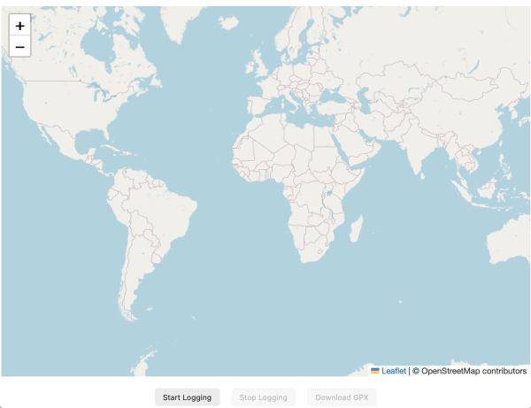
Sometimes, we set out to solve one problem and arrive at a bunch of even greater discoveries along the way. This story starts with my curiosity about whether you can get a “GPS” track log underground - like in a tunnel or underground car park.
In the second week (14th–19th February), we faced OSMMalawi. With no strategy to balance academics and mapping, I grew lazy. To overcome this, I wrote a sticky-note reminder on my laptop to push myself to map at least five tasks daily during breaks. By the end of the week, my contributions increased, and on 20th February, we celebrated another win, rising to 3rd place overall.
The third week (21st–26th February), the mapping match was against KabUyouth Mappers from Uganda. Bing imagery was unclear, but I adapted by using Google Earth references & comparing different imageries. My changesets piled up, promoting me from beginner to intermediate mapper. . We maintained the 3rd position but our captain organized a google meeting with Kingsley (one of the tournament organizers), who taught us valuable skills in both iD editor and JOSM.
By the fourth and fifth weeks (28th February–12th March), mapping had become part of my routine—even appearing in my dreams! Funny!!, am I right?
Despite some abrupt technical issues with OpenStreetMap login, we pushed through, won the game against YouthMappers Mukuba, and advanced to the next stage. By the end, we’re proudly ranked 4th among the top 10 contributing teams out of approx. 80 countries.
Thank you for reading my diary—I hope my journey inspires someone out there. Let’s map the world together! #SpatialMappers #AfricaMapCup2026. Cheers to all participants in this tournament, and please wish my team & I good for it’s still on going.
The third week (21st–26th February), the mapping match was against KabUyouth Mappers from Uganda. Bing imagery was unclear, but I adapted by using Google Earth references & comparing different imageries. My changesets piled up, promoting me from beginner to intermediate mapper. . We maintained the 3rd position but our captain organized a google meeting with Kingsley (one of the tournament organizers), who taught us valuable skills in both iD editor and JOSM.
By the fourth and fifth weeks (28th February–12th March), mapping had become part of my routine—even appearing in my dreams! Funny!!, am I right?
Despite some abrupt technical issues with OpenStreetMap login, we pushed through, won the game against YouthMappers Mukuba, and advanced to the next stage. By the end, we’re proudly ranked 4th among the top 10 contributing teams out of approx. 80 countries.
Thank you for reading my diary—I hope my journey inspires someone out there. Let’s map the world together! #SpatialMappers #AfricaMapCup2026. Cheers to all participants in this tournament, and please wish my team & I good for it’s still on going.
Challenges, Growth and Victory
In the second week (14th–19th February), we faced OSMMalawi. With no strategy to balance academics and mapping, I grew lazy. To overcome this, I wrote a sticky-note reminder on my laptop to push myself to map at least five tasks daily during breaks.OpenStreetMap
Every day at around 4 pm (unless there’s IRL business that I have to attend to), I log in to https://osmbc.openstreetmap.de/
to edit this week’s edition of WeeklyOSM.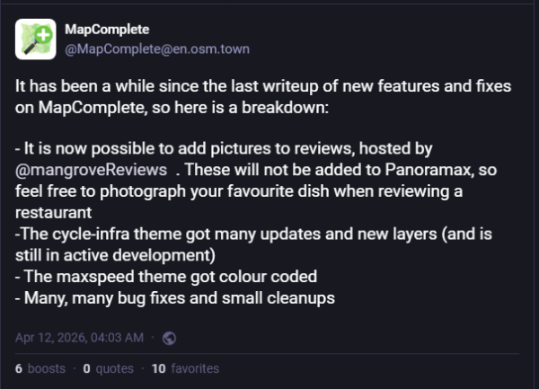
to edit this week’s edition of WeeklyOSM.
"A crowd-sourced review service for OpenStreetMap"
Every day at around 4 pm (unless there’s IRL business that I have to attend to), I log in to https://osmbc.openstreetmap.de/ to edit this week’s edition of WeeklyOSM.OpenStreetMap
I remember when my captain and I searched for willing mappers in our community to register for the tournament, which required at least 20 participants per team. One colleague discouraged me, saying it was highly impossible for us to be among the winners. However, that didn’t stop me from learning JOSM and joining the tournament.
In the first match week (7th–12th February), my team faced Carto Afrique of Kenya. The transition from iD editor to JOSM was amazing—tasks that once took over an hour now took only 30–40 minutes, giving me time to complete more. JOSM’s validation tool saved us from penalties by detecting errors before uploading.
On 13th February, the results were announced: my team won against Carto Afrique! That victory gave us our first point, lifted our spirits, and placed us 5th among the top 10 contributing teams. Yet, as my semester began, I feared balancing mapping with academics, sports, and assignments which would be tough, making the experience even more intense. ……..thank you to those that are reading my dairy. comment your review and lets share our experiences.
In the first match week (7th–12th February), my team faced Carto Afrique of Kenya. The transition from iD editor to JOSM was amazing—tasks that once took over an hour now took only 30–40 minutes, giving me time to complete more. JOSM’s validation tool saved us from penalties by detecting errors before uploading.
On 13th February, the results were announced: my team won against Carto Afrique! That victory gave us our first point, lifted our spirits, and placed us 5th among the top 10 contributing teams. Yet, as my semester began, I feared balancing mapping with academics, sports, and assignments which would be tough, making the experience even more intense. ……..thank you to those that are reading my dairy. comment your review and lets share our experiences.
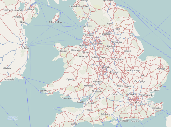
Ive been creating and serving web-based maps such as this one for some time. Thats based on raster tiles, and an osm2pgsql database is used to store the data that the tiles are created from, on demand as a request to view a tile is made.
The Beginning – Discovering JOSM..
I never imagined my mapping journey would reach this point in time. I would like to share with you my experience, which carried both doubts and excitement for my team and me—the thrill of learning Java OpenStreetMap (JOSM) and climbing the staircases that led to building victories in the Africa Map Cup 2026 Tournament. My name is Alvin Andrew Barugahara, also known as AlvinB (OSM name), a student from a mapping community in Uganda called Spatial Mappers at Ndejje University. I had always heard of JOSM and its simplicity in mapping OSM tasks. Back then, I was just a beginner mapper using iD editor, which was the default platform. It wasn’t bad, but it required constant internet access and had a small working window with few shortcuts, making mapping slow. My captain, Aikiriza Justus (OSM name), had a vision of teaching us how to use JOSM and become “advanced mappers.” He guided and pushed us beyond our limits through various Google meetings, preparing us for the Africa Map Cup 2026, which began on 7th February 2026. “Stay tuned for the next part of my Africa Map Cup journey…”
I never imagined my mapping journey would reach this point in time. I would like to share with you my experience, which carried both doubts and excitement for my team and me—the thrill of learning Java OpenStreetMap (JOSM) and climbing the staircases that led to building victories in the Africa Map Cup 2026 Tournament. My name is Alvin Andrew Barugahara, also known as AlvinB (OSM name), a student from a mapping community in Uganda called Spatial Mappers at Ndejje University. I had always heard of JOSM and its simplicity in mapping OSM tasks. Back then, I was just a beginner mapper using iD editor, which was the default platform. It wasn’t bad, but it required constant internet access and had a small working window with few shortcuts, making mapping slow. My captain, Aikiriza Justus (OSM name), had a vision of teaching us how to use JOSM and become “advanced mappers.” He guided and pushed us beyond our limits through various Google meetings, preparing us for the Africa Map Cup 2026, which began on 7th February 2026. “Stay tuned for the next part of my Africa Map Cup journey…”
Solar Farms
Looking into getting a gist for where there are solar farm setups both on land and in water (lakes , ponds ) etc
Below I will outline improvements for data interoperability regarding Wilderness Study Areas in the United States: https://en.wikipedia.org/wiki/Wilderness_study_area
Wilderness Study Areas (USA)
Below I will outline improvements for data interoperability regarding Wilderness Study Areas in the United States: https://en.wikipedia.org/wiki/Wilderness_study_areaOpenStreetMap
A few days ago, I asked the community about converting general GIS polygons into OSM multipolygon relations. I’ve searched online but havent found a workflow that fits my needs.
I’m planning to update and expand the administrative boundaries for Bali in OSM. I’ve already prepared the multipolygons for admin_level 5, 6, and 7 using single shared ways for efficiency. By leveraging Google Sheets, I’ve also compiled a comprehensive list of Wikidata, Wikipedia links, and multilingual names to better serve Bali’s international profile.
However, the conflation process is proving to be a challenge. The existing data is quite a “nightmare” to clean up; many roads and waterways are currently shared with administrative relations, and landuse or natural features are glued to the boundaries. Time to start untangling!
However, the conflation process is proving to be a challenge. The existing data is quite a “nightmare” to clean up; many roads and waterways are currently shared with administrative relations, and landuse or natural features are glued to the boundaries. Time to start untangling!
Mapping administrative boundaries in Indonesia can tricky especially when dealing with overlapping names. Here is my simplified workflow for preparing this data:
First, download the official spatial data from Peta Rupa Bumi by Badan Informasi Geospasial. This serves as the primary geometry source.
Since the source data is in polygon format, I use QGIS to extract the centroids (points). These points are essential for creating the
The polygons include Kemendagri reference codes. These are vital for:
Using spreadsheet tools and conflation techniques, I cross-reference the data to add:
To follow OSM best practices, I convert the polygons into independent ways (polylines).
Finally, I use the previously extracted place nodes to quickly copy and paste the relevant tags into the new multipolygon relations in my OSM editor.
1. Data Sourcing
First, download the official spatial data from Peta Rupa Bumi by Badan Informasi Geospasial. This serves as the primary geometry source.
2. Extracting Place Nodes
Since the source data is in polygon format, I use QGIS to extract the centroids (points). These points are essential for creating the
place=* tags that represent the center of each administrative area.3. The Importance of Kemendagri Codes
The polygons include Kemendagri reference codes. These are vital for:
Conflation: Ensuring data matches across different sets.
Identification: Many villages (admin_level 7 or 8) share the same name. The code helps distinguish them within a Regency or Province.
4. Enriching Metadata
Using spreadsheet tools and conflation techniques, I cross-reference the data to add:
wikidataandwikipediatags.
Multilingual names (name:en, etc.).
5. Geometry Processing
To follow OSM best practices, I convert the polygons into independent ways (polylines).
This allows adjacent areas to share a single boundary line via a multipolygon relation.
Once converted, I export the result as a.geojsonfile.
6. Final Tagging
Finally, I use the previously extracted place nodes to quickly copy and paste the relevant tags into the new multipolygon relations in my OSM editor.
🗺️ Entry 1 — Setting up JOSM & Plugins
Mapping Banjë, Albania
I started mapping the Banjë region in Albania by setting up my editing environment in JOSM.
⚙️ Setup
I configured JOSM with a set of plugins to support structured mapping and validation:
- utilsplugin2 – general productivity tools
- reltoolbox – relation and multipolygon editing
- waydownloader – working with connected geometries
- merge-overlap – cleaning overlapping features
- Relation Validation Plugin – checking data consistency
- FastDraw – faster geometry digitizing
🗺️ Mapping Context
The focus area is Banjë (central Albania) — a landscape with: - Complex terrain (valleys, rivers, slopes)
- Mixed land use (forests, agriculture, settlements)
- Incomplete or inconsistent OSM coverage
🌱 Initial Observations
- Landuse classification is often fragmented or overlapping
- Boundaries between forest, farmland, and settlements are not always clear
- Many features require clean multipolygon structures
- Validation tools already highlight conflicts in relations
🎯 Next Steps
- Clean and structure landuse polygons (forest, farmland, residential)
- Resolve relation conflicts and validation errors
- Improve consistency of tagging using presets
- Start refining settlement structures and road connectivity
OpenStreetMap is a map of the world, created by people like you and free to use under an open license.
Gashamo Hawd Somali Ethiopia is the city of Hawd Zone Somali Regional State of Ethiopia.
Gashamo Hawd Somali Ethiopia is the city of Hawd Zone Somali Regional State of Ethiopia.
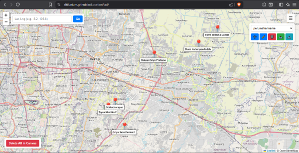
So, Ive been using Altilunium LocationPad for several of my personal projects until now. But recently, I encountered several problems.
I was recently reading Demographic deposit, dividend and debt by Sonalde Desai. Following the Standard Operating Procedure, I looked up this Sonalde person and turns out she is a researcher at a research institute in Delhi called National Council of …
I just published a hacky but effective tool to fix wrong tag values. This lead to some 50 edits only this morning.
Ive been working on Strado, a free tool that scores every neighborhood across 50 European cities using data from OpenStreetMap. I wanted to share the project with the OSM community since its built entirely on your work.
Following up on https://www.openstreetmap.org/user/lhirlimann/diary/404921, I discovered today that newer/better aerial imagery for some parts of Mongolia were available, hence doing me doing some edits.
Cool newer images for mongolia
Following up on https://www.openstreetmap.org/user/lhirlimann/diary/404921, I discovered today that newer/better aerial imagery for some parts of Mongolia were available, hence doing me doing some edits.OpenStreetMap
As reported on the Irish OpenStreetMap website, we recently finished mapping all the buildings in Co. Down. Due to my goal to get high up in the UK statistics (I made it to #1), I apparently mapped 3,283 tasks, if Im reading the statistics right.
more archaeological discoveries and how should I map them?
As reported on the Irish OpenStreetMap website, we recently finished mapping all the buildings in Co. Down. Due to my goal to get high up in the UK statistics (I made it to #1), I apparently mapped 3,283 tasks, if Im reading the statistics right.OpenStreetMap
I really love JOSM, and the more I use it, the more I discover that it offers some very useful features that some of you may not be aware of ! Even if some are less useful, simply knowing they exist opens up the possibility that you might find them u…
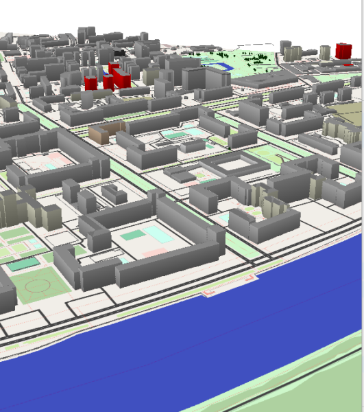
The Hub, Edinburgh rendered with Beakerboys OSM Building Viewer https://beakerboy.github.io/OSMBuilding/index.html?id=42997989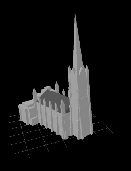
The Hub, Edinburgh building tagging
The Hub, Edinburgh rendered with Beakerboys OSM Building Viewer https://beakerboy.github.io/OSMBuilding/index.html?id=42997989OpenStreetMap
Back home with Mom for the weekend, when I picked her up after church, I was advised by everyone that taking the back exit from the church parking lot. What back exit? It wasnt on OSM or GM.
此文本同時提供 台灣華語版本
This article is also available in Taiwanese Mandarin
This article is also available in Taiwanese Mandarin

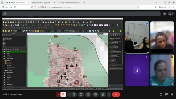
First meeting. Source of basemap (c) OpenStreetMap contributors.
%{count} contribution(s) in the last year
section on the user page, should be edited. For numbers greater than four digits, periods are placed in groups of three for easier reading, but OSM user profiles have numbers that are difficult to read, such as 1234565885. If we write this as 1.234.565.885 or 1,234,565,885. The contribution counter will be easier to read.
section on the user page, should be edited. For numbers greater than four digits, periods are placed in groups of three for easier reading, but OSM user profiles have numbers that are difficult to read, such as 1234565885. If we write this as 1.234.565.885 or 1,234,565,885. The contribution counter will be easier to read.
Contribution in the last year
section on the user page, should be edited. For numbers greater than four digits, periods are placed in groups of three for easier reading, but OSM user profiles have numbers that are difficult to read, such as 1234565885. If we write this as 1.234.OpenStreetMap
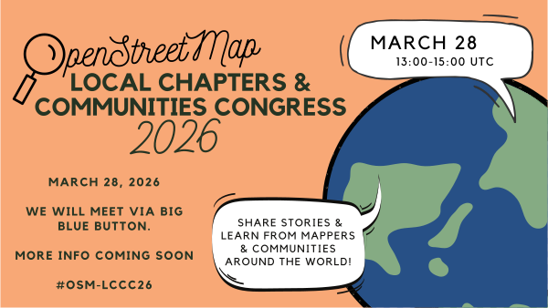
Yesterday, I attended the OpenStreetMap Local Chapters and Communities Congress 2026 online.
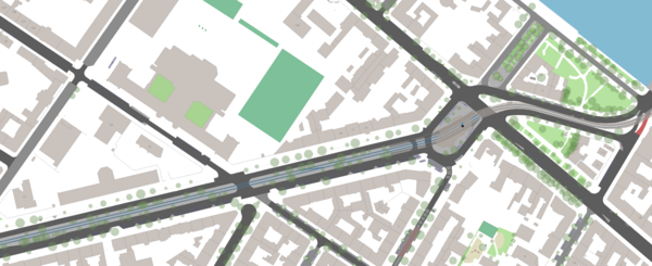
This text was written by me a couple weeks ago. In the mean time I noticed that my computer struggles with the amount of data to process. That’s why I will need to use another way how to create my map.
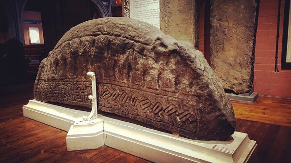
Yesterday or the day before, Florian contacted me to see could we map hogbacks on OpenStreetMap. Short answer: Yes.
I’ve recently learnt how to use the “Building” plugin on JOSM and it’s so slay.
building plugin
Ive recently learnt how to use the Building plugin on JOSM and its so slay.OpenStreetMap
Hello! I made my 1000th edit today which also just so happened to roughly coincide with the 1 year mark of my OSM journey. I have had so much fun learning about OSM and connecting with so many cool members of the community.
I started my work on OSM improving the data in my home town of Wilson Wyoming, which continues to be my main focus, although I have done some smaller projects outside of this area. It has been so rewarding to watch my work come together to create such a carefully detailed representation of its unique and beautiful geography. Through all this work I have not only deepened my passion for geographic data, I have had the pleasure of developing the understanding necessary to truly comprehend the marvel of the world’s greatest map, the open street map. I couldn’t be happier to be a part of such a remarkable feat of humanity and commendation to our planet.
Speaking of Wilson, I began a series of diary entries early on where I would provide updates for my “Wilson WY data overhaul project”… I have since stopped doing this and kinda wish I could delete them (if you know how to delete them let me know). Anyways, I bring this up because Wilson has served as a kind of playground where I have and continue to develop my process for creating the most useful, high detail, well tagged, good-lookin’ data possible. This unfortunately hasn’t happened without some growing pains if you will. There are many things that I am not super proud of. For example, the fact that Fish creek has 30 versions in its way history, or the many driveways, roads, and ponds that have an absolutely egregious amount of nodes due to my disdain for jagged curves and my proclivity for getting carried away in my endeavour to make every curve pretty. I am a victim to the coastline paradox. However, this is something I believe I have improved on. Anyways, this entry is mostly for my own personal posterity, but if you are reading this, or are interested in the work I have done on OSM please reach out to me. I absolutely love to make connections with other mappers!
I started my work on OSM improving the data in my home town of Wilson Wyoming, which continues to be my main focus, although I have done some smaller projects outside of this area. It has been so rewarding to watch my work come together to create such a carefully detailed representation of its unique and beautiful geography. Through all this work I have not only deepened my passion for geographic data, I have had the pleasure of developing the understanding necessary to truly comprehend the marvel of the world’s greatest map, the open street map. I couldn’t be happier to be a part of such a remarkable feat of humanity and commendation to our planet.
Speaking of Wilson, I began a series of diary entries early on where I would provide updates for my “Wilson WY data overhaul project”… I have since stopped doing this and kinda wish I could delete them (if you know how to delete them let me know). Anyways, I bring this up because Wilson has served as a kind of playground where I have and continue to develop my process for creating the most useful, high detail, well tagged, good-lookin’ data possible. This unfortunately hasn’t happened without some growing pains if you will. There are many things that I am not super proud of. For example, the fact that Fish creek has 30 versions in its way history, or the many driveways, roads, and ponds that have an absolutely egregious amount of nodes due to my disdain for jagged curves and my proclivity for getting carried away in my endeavour to make every curve pretty. I am a victim to the coastline paradox. However, this is something I believe I have improved on. Anyways, this entry is mostly for my own personal posterity, but if you are reading this, or are interested in the work I have done on OSM please reach out to me. I absolutely love to make connections with other mappers!
In the last quarter of 2025, I was privileged to be part of the HOT Mentorship Program. I was a mentee in the third cohort, focusing on Open Community Building.
This post presents the results of a student project carried out by the following group: Pierrick Causeret, Humbert de Chastellux, Paul Enjalbert and Othman Ouhaddou.