The full knowledge boy from Wakisi Dekabusa. He ended in Primary Seven at Sofraa Primary School. No College But Full Knowledge Capacity Boy. He Started Hustling In 2013 At 11 Year Old Age. In Mayuge District As Water Server, In 2015 He Went Kyegwegwa At 13 Years Old. He Hustle As House Boy. In 2017 He Went Kampala And Started To Selling Boiled Eggs. In 2018 He Started Mechanical Engineering In KiKubamitwe. After He Went Jinja And Started A Job Of Machanicing, He Took 4 Years Before COVID-19.
In 2022-December He Started A Company Of K.O.V INVESTMENT.
The Company Deals In ;- Shoes, Boda-Boda Management, Shops Retail And All-Sell.
In 2022-December He Started A Company Of K.O.V INVESTMENT.
The Company Deals In ;- Shoes, Boda-Boda Management, Shops Retail And All-Sell.

KABENJJE OMAR VARTEL (K 🤕 V)
The full knowledge boy from Wakisi Dekabusa. He ended in Primary Seven at Sofraa Primary School. No College But Full Knowledge Capacity Boy. He Started Hustling In 2013 At 11 Year Old Age.OpenStreetMap
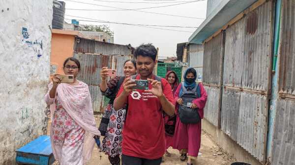
On May 16, 2025, YouthMappers at Eastern University, Bangladesh successfully conducted an Open Field Mapping activity using Mapillary, a platform for crowdsourced street-level imagery.
Hi everyone! Im Archit Rathod, a Computer Science Masters student at the University of Illinois Chicago and a passionate open-source contributor.
While editing the next edition of WeeklyOSM, I stumbled upon a fascinating case study that caught my full attention.
Its been a year since my last diary entry on this, and I havent done too much (I dont think) in that timeframe. The GIF below should give a good idea of the progress made.
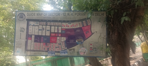
I have a craze for adding addresses to OSM. Unfortunately, in Delhi it is ridiculously hard to find a place with addresses properly displayed on the front.
Jetzt ist klar: die letzten vier Blog-Einträge werden automatisiert angezeigt. Weshalb auch immer das sein muss …
Nur um mal zu schauen, wieviele Einträge im Profil ausgebreitet werden.
Warum erscheint der letzte Blog-Eintrag automatisch, wenn man alle Blog-Einträge doch aufrufen kann, wenn man daran interessiert ist?
Hat jeder oft mehrere Jahre alter letzter Eintrag noch Relevanz?
Wieso hat man wie auch bei der Aktivitätsdarstellung keine Möglichkeit, selbst festzulegen, ob man das will? Im Forum war die Mehrheit für eine solche selbstbestimmte Lösung. Aber sowas interessiert die DWG ja nicht.
Hat jeder oft mehrere Jahre alter letzter Eintrag noch Relevanz?
Wieso hat man wie auch bei der Aktivitätsdarstellung keine Möglichkeit, selbst festzulegen, ob man das will? Im Forum war die Mehrheit für eine solche selbstbestimmte Lösung. Aber sowas interessiert die DWG ja nicht.
OpenStreetMap is a map of the world, created by people like you and free to use under an open license.
Following mobilization of volunteers and OSm newbies at Benue State University to kick-start a new chapter and team of Unique Mappers to drive Map Nigeria Mapathon project and the Makurdi on going project .We had a training for newbies. More than 20 newbies has been mobilized and signed up to OSM. These include William Hundu, the Team Coordinator, Lucas, Glory,Shater ,Jacob an others After the virtual meeting ,I hope to travel to Makurdi for in-person training and MOU with the University and Unique Mappers Network,Nigeria
Also .we are planning for stakeholders workshop for data use cases
Also .we are planning for stakeholders workshop for data use cases

Meeting with Newbies for Orientation at Unique Mappers Chapter Benue State
Following mobilization of volunteers and OSm newbies at Benue State University to kick-start a new chapter and team of Unique Mappers to drive Map Nigeria Mapathon project and the Makurdi on going project .We had a training for newbies.OpenStreetMap
So much data can be added, it’s very cool
I want to try to add a lot of QLD Translink services.
OpenStreetMap is just OpenMap at this point :P
OpenStreetMap is a map of the world, created by people like you and free to use under an open license.OpenStreetMap
My Introduction as a 2025 HOT Voting Member Nominee
Transliteration Summer Project + Intro!
So today I get to talk other mappers. and I get to know how they map the challenges the have like; 1. Unavailability of internet connection 2. lack of Devices or tools for mapping etc. After the challenges we get to talk about solutions where we find a solution about getting a router and recharging it so the mappers in a particular area can come together and use it for mapping. And we still Provide systems for those without system to use for mapping till they get their own. I really learned alot from their experiences then by the end of this week i will be able to use JOSM cause we are suppose to be taught by a more experienced mapper. I really enjoy mapping and i still plan to meet mappers around the world so we can share our ideas together

Talking to other Mappers around the country
So today I get to talk other mappers. and I get to know how they map the challenges the have like; 1. Unavailability of internet connection 2. lack of Devices or tools for mapping etc.OpenStreetMap
Nisreen Mahmoud, 2025 HOT Voting Member Nominee
So, I got invited to speak at a certain OSM community’s monthly online talk.
Post-disaster mapping workshop with OpenStreetMap and JOSM
Today, Monday 19th May 2025, Made me one week at my IT, And so far i can say it has been great for me, Topping the chart, mapping over Thousands of building just in one week. Yes i sign up for this, that’s why I’m here to lead and take the topflight. Saying about today, I got the opportunity to teach and lecture one of my new IT College on what OpenStreetMap Is, His name is Alex though, And it was fun throughout the whole process. For fact, i know a lot is gonna come my way through this program, which I’m waiting for it and ready for success!!!

ONE WEEK AT INDUSTRIAL TRAINING
Today, Monday 19th May 2025, Made me one week at my IT, And so far i can say it has been great for me, Topping the chart, mapping over Thousands of building just in one week. Yes i sign up for this, thats why Im here to lead and take the topflight.OpenStreetMap
Hoffen wir mal, dass die Leute nicht auf die OpenStationMap zurückgreifen oder sich zumindest denken können, dass der Fahrstuhl so nicht aussieht.
So today i learned what is mapping and how to map and i mapped some building. it was a beautiful experience and i really enjoyed it. i met a guy called fortune he taught me almost everything i learned about mapping he is and easygoing guy, i still met a lot of fun people that will make learning easy. When i started i first learned what is mapping the site used for mapping which was later introduced as OSM US tasking manager. after that i created my account did my first mapping under the supervision of fortune and when he checked what i did and approved it i continued with some project he gave me and i finished 2 mapped task.
An open, cross cutting feature request for streetcomplete, everydoor, organicmaps and anyone else who targets mobile data capture.
Why: Google maps does this for reviews, to great effect. Ask me, while I am at a restaurant, with a physical menu “Is the cuisine vegetarian?” Or “what’s the website?” (Often printed on menus) Ask me, while I am a cafe, “is there outdoor seating?”
The problem this solves is often I don’t know when a favourite place is missing data. I go there all of the time, why wouldn’t it be mapped?
Give me a “no thanks” option so if I don’t want the intrusion I can opt out easily. But if I hit “yes please, nudge me”…
- Ask for location detection (yup), device activity sensors (maybe not already asked for)
- If I am detected in the same place and that place has a shop=* or amenity=* for 5-15 minutes
- Activity detected is “still” or similar (I put my phone down, or walked around a shop)
- Can I please get a nuanced prompt at some point either then or within a few hours?
- And limit current notifications to 1
Why: Google maps does this for reviews, to great effect. Ask me, while I am at a restaurant, with a physical menu “Is the cuisine vegetarian?” Or “what’s the website?” (Often printed on menus) Ask me, while I am a cafe, “is there outdoor seating?”
The problem this solves is often I don’t know when a favourite place is missing data. I go there all of the time, why wouldn’t it be mapped?
Give me a “no thanks” option so if I don’t want the intrusion I can opt out easily. But if I hit “yes please, nudge me”…
Following various discussions and requests over the previous years, Ive adapted parsing of the machine-readable tag in waymarkedtrails for route symbols to cover more use cases.
Announcing changes to `osmc:symbol` rendering in waymarkedtrails
Hello fellow mappers,
I’m Ezekiel Kiariro, a passionate GIS and remote sensing expert based in Tanzania, and I’m truly honored to be nominated as a 2025 Voting Member of the Humanitarian OpenStreetMap Team (HOT).
I’m Ezekiel Kiariro, a passionate GIS and remote sensing expert based in Tanzania, and I’m truly honored to be nominated as a 2025 Voting Member of the Humanitarian OpenStreetMap Team (HOT).
Although I read the newspaper (almost) every day, lately I’ve been getting news faster through my social circle. It usually starts as a rumor from an online friend, popping up on my timeline :
I am honored and humbled to introduce myself as one of the nominees for the 2025 Humanitarian OpenStreetMap Team (HOT) Voting Membership.
My name is Adamu Muhammad Adamu, a geographer, mapping advocate, and dedicated leader from Gombe State, Nigeria. I currently serve as the President of the National Association of Geography Students (NAGS) at Gombe State University, where I also lead our active YouthMappers chapter—a platform that has significantly shaped my journey into open mapping, humanitarian work, and global collaboration.
To me, HOT stands at the intersection of technology and humanity, where data becomes a tool to respond to crises, build resilience, and bring visibility to marginalized communities. It is through HOT that young people like myself have found a purpose in contributing to real-world solutions, bridging the gap between global challenges and local realities.
In 2024, I was proudly selected as a Leadership Fellow to represent my country in Bangkok, Thailand, and now selected as a Volunteer Regional Ambassador for YouthMappers in Nigeria, a role through which I support chapters across the country, encourage inter-campus collaboration, and promote open mapping as a vehicle for humanitarian and sustainable development.
The goal was to use geospatial data to highlight the community’s challenges and advocate for government and NGO intervention.
Thank you for taking the time to learn about me. I look forward to connecting with many of you, learning from your experiences, and growing together as part of this incredible community.
With sincere gratitude,
Adamu Muhammad Adamu President – (NAGS) Gombe State University Volunteer Regional Ambassador, YouthMappers – Nigeria OSM: adamutafidah
My name is Adamu Muhammad Adamu, a geographer, mapping advocate, and dedicated leader from Gombe State, Nigeria. I currently serve as the President of the National Association of Geography Students (NAGS) at Gombe State University, where I also lead our active YouthMappers chapter—a platform that has significantly shaped my journey into open mapping, humanitarian work, and global collaboration.
- What HOT Means to Me
To me, HOT stands at the intersection of technology and humanity, where data becomes a tool to respond to crises, build resilience, and bring visibility to marginalized communities. It is through HOT that young people like myself have found a purpose in contributing to real-world solutions, bridging the gap between global challenges and local realities.
- My Journey into Mapping and HOT
In 2024, I was proudly selected as a Leadership Fellow to represent my country in Bangkok, Thailand, and now selected as a Volunteer Regional Ambassador for YouthMappers in Nigeria, a role through which I support chapters across the country, encourage inter-campus collaboration, and promote open mapping as a vehicle for humanitarian and sustainable development.
- Selected Projects and Community Impact
- Kwakwambe Village Mapathon – Adamawa State.
The goal was to use geospatial data to highlight the community’s challenges and advocate for government and NGO intervention.
- Mapping for Heat and Health – Akure and Gombe
- Leadership, Training & Mentorship
- Why I Want to Serve as a HOT Voting Member
- My Responsibilities and Vision as a Voting Member
As a voting member, I believe it is my duty to:
Advocate for inclusive and community-centered mapping practices
Contribute to HOT’s governance with integrity and transparency
Support the development of sustainable local mapping ecosystems
Collaborate across borders to advance shared humanitarian goals
- I plan to participate actively in HOT working groups, especially those focused on:
Youth Engagement and Leadership Development
Climate Resilience and Disaster Response
Diversity, Equity, and Inclusion in Open Mapping
- HOT’s Greatest Challenge and My Perspective
Expanding access to funding and mentorship for local initiatives
Building stronger partnerships between HOT and academic institutions
Creating inclusive feedback mechanisms where mappers can influence global strategies
Encouraging intergenerational collaboration across the mapping community
- Final Thoughts
Thank you for taking the time to learn about me. I look forward to connecting with many of you, learning from your experiences, and growing together as part of this incredible community.
With sincere gratitude,
Adamu Muhammad Adamu President – (NAGS) Gombe State University Volunteer Regional Ambassador, YouthMappers – Nigeria OSM: adamutafidah
My Journey to HOT Voting Member Nomination
I will stop editing here after more than year of contribution because of various reasons, mainly political reasons.
I feel like continuing to support the project which is politically involved in mapping scope is not my moral thing to do anymore.
OSM’s ridiculous policy about who controls the ground, those determine the border is far more ridiculous than occupation itself. I am not surprised that these people do not understand what is international recognition means. The policy of “who controls the ground” is simply supporting any “invasion / annexation / or whatever term here” and running away from the reality of internationally recognized borders. If OSM is run by Europeans or Americans or Russians (who support their invasions and military presence in Moldova, Ukraine and Georgia) I am not remotely shocked. Because if they understood, world would not have been this trash since WW2.
I have seen it first time when I was removing fake Armenian names from the Karabakh area (was under occupation in between 1992 and 2024), DWG contacted me about not removing them because they have talked to Armenians who felt nostalgically bad about those. I was in utter shock for an American in DWG who did not think about occupation a second, but being fully biased on occupiers side asking how they would feel.
The same goes to Russo-Ukrainian war, for some reason they show Donbas as Ukraine area while it is under occupation, but showing Crimea not as a part of Ukraine while it is under annexation and occupation.
Same situation is with Georgian occupied areas.
I am familiar with double standards of Europeans, so no surprise here at all. You guys can enjoy mapping with disputed areas and changing borders every day.
Good luck to you all!
I’m a skilled cartographer and GIS professional with expertise in mapping, spatial analysis, and information visualization using various software, including ArcGIS, QGIS, AutoCAD, ACAD, and OpenStreetMap. I create informative maps, conduct network analysis, and perform connectivity studies to drive insights and inform decision-making, leveraging my skills in GIS mapping, spatial analysis, and cartography to deliver high-quality solutions and contribute to projects that require spatial analysis, mapping, and data visualization.

My profile
Im a skilled cartographer and GIS professional with expertise in mapping, spatial analysis, and information visualization using various software, including ArcGIS, QGIS, AutoCAD, ACAD, and OpenStreetMap.OpenStreetMap
Cartographers in Uganda’s National Water and Sewerage Corporation would play a vital role in water resource management by creating maps of water infrastructure, such as pipes and treatment plants, and mapping water sources like rivers and lakes. They would also identify areas prone to flooding, monitor water quality, and inform infrastructure planning using geospatial data. By providing accurate spatial data, cartographers would enhance planning, efficiency, and decision-making, working closely with engineers, hydrologists, and environmental scientists to ensure effective water resource management and infrastructure development.

Gis
Cartographers in Ugandas National Water and Sewerage Corporation would play a vital role in water resource management by creating maps of water infrastructure, such as pipes and treatment plants, and mapping water sources like rivers and lakes.OpenStreetMap
May 16, 2025 (22.46 PM) : Before starting validation on Project 18915, would you mind assisting with validation on another project first? It would be helpful for practice on a few tasks/grids beforehand.
A particular goal of mine will be to map Jackson Mississippis highest poverty areas.
Source: Poverty Rate by Open Data for the City of Jackson, MS
Source: Poverty Rate by Open Data for the City of Jackson, MS
Joining the Unique Mappers Network Nigeria has been a turning point for me. As a passionate student of Surveying and Geoinformatics, stepping into the world of OpenStreetMap was like unlocking a new level in my career and community impact journey.
My OSM Goals Contribute high-quality spatial data that makes real-life impact Master advanced mapping tools like JOSM, iD Editor, and HOT Tasking Manager Inspire fellow students and young professionals in Nigeria to embrace open mapping Support humanitarian mapping, disaster response, and climate resilience efforts.
To Everyone in the OSMFight Arena… This is more than a competition – it’s a movement. A call to action. A chance to leave our digital footprints across the globe. So whether you’re mapping buildings in Port Harcourt, roads in Kano, or health facilities in Bauchi – know that YOU are making a difference.
Let’s light up the map, one building at a time! Let’s bring the crown home 🏆🗺️ Let’s make Unique Mappers Network Nigeria proud 🙌🏾💚
It works !! OSMfight as a gamification for community engagement of OSM contribution -This week we are engaging paired mappers for OSMfight for the next one week - we need to get our project task
running,engaging and fun to map
https://tasks.
running,engaging and fun to map
https://tasks.
Deutsche Post, which operates almost all of Germanys postboxes,
recently changed the collection times for most of them. This was
discussed on the
German Forum
starting 4th of April. I wondered if this could be seen in the
database.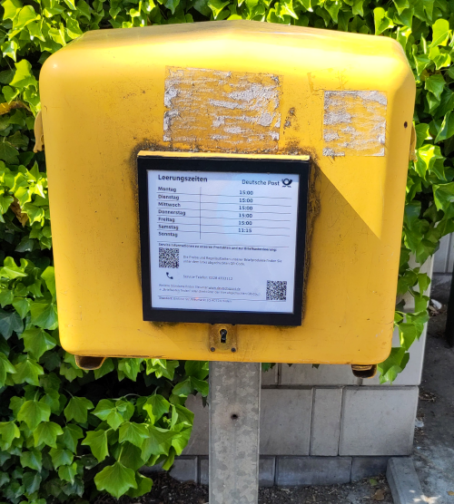
recently changed the collection times for most of them. This was
discussed on the
German Forum
starting 4th of April. I wondered if this could be seen in the
database.

Postboxes with New Collection Times
Deutsche Post, which operates almost all of Germanys postboxes, recently changed the collection times for most of them. This was discussed on the German Forum starting 4th of April. I wondered if this could be seen in the database.OpenStreetMap
Streetcars Rule
I’m trying to make a map of a streetcar line that I think ought to be built.
Starting a Project
Im trying to make a map of a streetcar line that I think ought to be built.OpenStreetMap

