Hello everyone, I have come to the conclusion that the daily mapping challenge I started was probably too ambitious considering my daily life (mainly univ), so I have no choice but to downgrade my ambitions unfortunately. I still will make my best to contribute everyday to OSM and to make daily diary entries, however they won’t be all about mapping a random municipality.

About my daily challenge
Hello everyone, I have come to the conclusion that the daily mapping challenge I started was probably too ambitious considering my daily life (mainly univ), so I have no choice but to downgrade my ambitions unfortunately.OpenStreetMap
In addition to OSM, I occasionally take pictures of the areas I visit to upload them on Mapillary.
Today (or rather, yesterday), I worked on Illois. Near this little village, there is the A29 highway and the D 929 road. There arent too many single-family homes, mainly because quite a few buildings are for agricultural purposes.
Recently I’ve noticed that most of the time I spend on OSM goes either to:
Burnout can also lead to a premature transformation into a nagging grump, which I would love to avoid.
Solution: People with the know-how should instead focus more on providing the best documentation and tooling there is possible to the community. Working on removing ambiguities, providing accurate descriptions and thorough examples. Therefore everyone can learn (and later teach) the right approaches. This pro-active approach is more effective than a re-active one, since less time and work goes to waste, the knowledge is propagated more quickly and in a more lasting manner, economics of scale start to kick in and stuff.
Also at the time of writing this entry it is 1 AM CEST where I live so I guess this makes this post #showerthoughts -approved. Thank you for coming to my TED talk.
- Patrolling recent changes and fixing things which, although were already mapped correctly for years (often by myself), now have been altered (probably in good faith though!) by some newbie who „thought” that the current state is somehow wrong
- Fixing things which were already mapped incorrectly for years (often by myself) at a time when the documentation was unclear or the community consensus was different
Burnout can also lead to a premature transformation into a nagging grump, which I would love to avoid.
Solution: People with the know-how should instead focus more on providing the best documentation and tooling there is possible to the community. Working on removing ambiguities, providing accurate descriptions and thorough examples. Therefore everyone can learn (and later teach) the right approaches. This pro-active approach is more effective than a re-active one, since less time and work goes to waste, the knowledge is propagated more quickly and in a more lasting manner, economics of scale start to kick in and stuff.
Also at the time of writing this entry it is 1 AM CEST where I live so I guess this makes this post #showerthoughts -approved. Thank you for coming to my TED talk.

(Clickbait title) Experienced OSM Mappers should NOT map OSM. Here's why.
Recently Ive noticed that most of the time I spend on OSM goes either to:OpenStreetMap
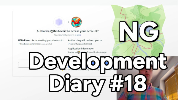
Its time for another OpenStreetMap-NG development update! This week brings exciting new features and improvements that bring us closer to the projects first public release.
Parks on the Air (POTA) information tags can be added to areas. Its an improvement over the POTA map application as it shows the entire park area rather than a point.
For example, the Victoria Harbour Migratory Bird Sanctuary (CA-4248)
https://pota.
For example, the Victoria Harbour Migratory Bird Sanctuary (CA-4248)
https://pota.
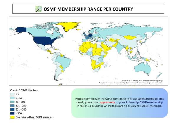
Key highlights: We are happy to share the accomplishments of the 2024 OSMF Membership Campaign: 1) ~ 392 sign up’s from March, most of them were through the Active Contributor Membership Program; 2) there are now members in 16 new countries!; 3) Four…
Well it has been a while. As the result, Im 3 cities late. Fortunately, one week of holidays is coming, so I will have quite a lot of time to catch up.
Embark on a thrilling Chitwan jungle safari and immerse yourself in the vibrant ecosystem of Nepals Terai region. Heres a guide to help you plan your adventure:
One of Nepals most beautiful trekking routes is the Gokyo Trek in the Everest region, which offers tranquil glacial lakes, serene pathways, and amazing vistas of Mount Everest.
Balaji Kirpa Travels provides quick and efficient taxi services in Amritsar. Whether you need a taxi in Amritsar for local travels, a car hire for city tours, or a one-way taxi service, we have you handled.
https://princetontx.gov/DocumentCenter/View/3004/Princeton-Tax-Increment-Reinvestment-Zones-TIRZ_Whitewing-Trails-Phase-2 has information about the Phase 3

Whitewing Trails Phase 3
https://princetontx.gov/DocumentCenter/View/3004/Princeton-Tax-Increment-Reinvestment-Zones-TIRZ_Whitewing-Trails-Phase-2 has information about the Phase 3OpenStreetMap
A few days ago, I started my mapping project for Jāņupe. The main objectives of this project are to add all the missing houses in the area, re-tag the existing ways and some nodes, and retrace the residential and allotment zones.
Revamp and modernize your applications with our comprehensive Application Enhancement Services. From re-engineering legacy systems to integrating modern technologies, we ensure your IT applications operate at peak efficiency.
Im still late : I was supposed to do a municipality with the letter H today. I probably wont do the letter I tomorrow either, nor Wednesday, however Im pretty sure I will be able to on thursday.
Volunteerism, commitment, and dedication are our hallmarks as YouthMappers!
Whoof!
Its my first Diary entry.
Its my first Diary entry.
Today, I worked on Fallencourt. This village is smaller than the previous ones I worked on for my challenge, however something big is nearby, the A28 highway (Id guess it creates quite a lot of noise).
a small project of mine over the last few years (in my spare time, when I’m not doing the job I get paid to do) is to map every building in the Kingston and new Malden area of SW London.
This is slow progress although I have now nearly finished all but a small part of Old Malden and an area of North Kingston. Although slow, the map does now look aesthetically significantly better than it did two years ago. although I am aware it could be improved further by putting house numbers on each building, I do have to keep my mental health in check here.
The Previously patchy; Berrylands, Norbiton, and Surbiton have now all been finished with finishing Old Malden being my next project and then Coombe and Ham Kingston Vale, being my next major projects
I have always found it frustrating that people will often do one or two houses on the road and then get either bored (or do their own house).
These diary entries are more to help me keep track of what iv done to date as well as give a minor update to the larger community on the slow updates.

Grater London South West
a small project of mine over the last few years (in my spare time, when Im not doing the job I get paid to do) is to map every building in the Kingston and new Malden area of SW London.OpenStreetMap
Yes I know, I already missed a day for my challenge. Apologies, I will do 2 cities tomorrow.
OpenStreetMap Foundation 2024 chairperson's report

Stereo's Diary | OpenStreetMap Foundation 2024 chairperson's report
Dear OpenStreetMap Community and fellow mappers,OpenStreetMap
I was round that way this morning and confirm that there is no number 38 Crammond Place. One row finishes at 37 and the adjacent row starts at 39!
I have lived in North Muirton since 1973 and never realised this obscure fact until mapping the area.
I think, but don’t know for definite, that it is because there used to be (in the early years of NM) a council rent office in the row 39-47 which maybe didn’t have a house number and this has caused a “missing” house when the rent office ceased to be.
In the unlikely event anyone who knows reads this stuff then please let me know.
Every year the Bujang Gadis Unsri holds an election for Girls and Boys from Sriwijaya University. This activity was attended by 60 pre-semi-finalist participants at Sriwijaya University.
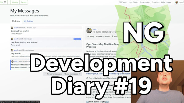
Welcome to the latest OpenStreetMap-NG development update! Since last time, weve made significant progress towards reaching feature parity and have also implemented some great, exclusive new features.
Here is my first diary entry.
A few days ago, I gave myself the following challenge : every day, I will map one city in my department (Seine-Maritime, 76, France), going to the next letter in the alphabet for the next day, and so on.
A few days ago, I gave myself the following challenge : every day, I will map one city in my department (Seine-Maritime, 76, France), going to the next letter in the alphabet for the next day, and so on.
Once again i have the pleasure to announce that we, the OpenStreetMap Carto maintainers, have prepared a new release of the OpenStreetMap Carto stylesheet (the default stylesheet on the OSM website). Once changes are deployed on openstreetmap.
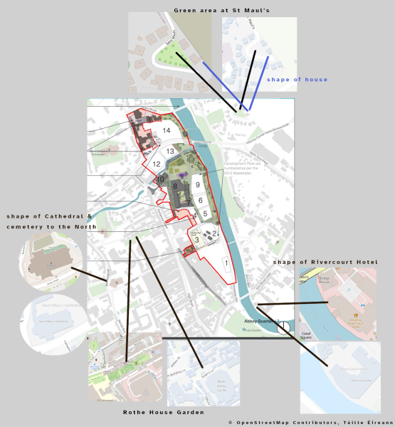
I came across an article with a map in our local newspaper yesterday via a Facebook post, and at once, I thought Oh, this map looks very much based on OSM.
GayChatLineHub is a trusted chat line directory that has a list of all free trial gay phone chat lines in one place. Explore your deepest desires with tons of gay men who live in your local area and connect with them instantly.
There doesnt appear to be a resource available to aid in mapping The Mississippi Schools for the Deaf and the Blind, making it that much more important to map.
One of my current focuses is the University of Mississippi Medical Center. To my surprise, much of the campus was not mapped - specifically buildings and parking garages. I get it - it looks a daunting task and it is.
Un lieu de detente et decrencontre entre fumeurs de cannabis à à torremolinos-malaga dans la province de l’Andalousie.0034631771469
Boost your online presence with SEO services in California. We specialize in local SEO, helping businesses of all sizes stand out in the competitive Californian market.
Moin,
weiß jemand warum die Navigation per OsmAnd auf Nebenstraßen keine Höchstgeschwindigkeiten und Richtungsangaben anzeigt obwohl sie gemappt sind?
Netten Gruß Werner
weiß jemand warum die Navigation per OsmAnd auf Nebenstraßen keine Höchstgeschwindigkeiten und Richtungsangaben anzeigt obwohl sie gemappt sind?
Netten Gruß Werner
You know what can really mess up carefully laid plans? What can even lead to a dangerous situation? When you get to the crossing of the South Fork Trinity River Trail and the East Fork South Fork Trinity River, a waterway that very much is still a river, and that bridge that someone has assured you they know is there is not there. There’s not even the evidence of once having footings for a bridge.
Apparently the mapper knew based on Bing aerial photography. Through thick trees. I can make guesses about how that crossing goes, too. At least when I guess wrong, I know it was a guess and might have made contingency plans around it.
Fortunately in the early days of Autumn, that ford I was LIED to about is just 4m of knee high wading without much current. That river comes out of some mountains that collect snow. It isn’t always so low.
The thing is, if it is important, it HAS to be correct. Your guess isn’t good enough. If it isn’t important, it can be left until someone who knows feels like doing it. There’s no renderer having trouble deciding how to render this crossing. It’s quite common that they aren’t specified.
I’ve been coming across a lot of guesses lately. I know they are guesses because they are wrong.
I was looking over an area I’d been working on when something started feeling wrong. It took me a couple minutes to notice that one of the roads I had aligned recently had sprouted four bridges. What? It was the unimportant spur of an unimportant low standard Forest Service road. They also get referred to as “unimproved” roads. We’re talking a road that might be produced simply by running a blade across the dirt. The whole thing probably cost a fraction of the cost of a bridge and suddenly it had four. Based on Bing imagery again, in which you can clearly see it is just a dirt road.
Why did this person do this? Well, they don’t like to see errors on the map. IT’S NOT AN ERROR. They were using iD, which uses yellow colors and the term “issue” for this sort of thing. It uses red colors and the term “error” for errors. You know what is an error? Fake bridges. But no automated error catcher is going to see those.
They added that “we can’t have” people just drawing roads over waterways without saying how they cross. Well, the road is there. The waterway might be. I’ve seen these NHD lines climb over ridges, so it’s debatable. But let’s assume the waterway is there. Seems more important that they are on the map than that we know how they cross. We can’t just leave roads off because we don’t know how they cross the waterway.
I was adding in details along a trail I’d just hiked in Prairie Creek Redwoods State Park when I noticed the beautiful curving footbridge across Hope Creek was marked as a ford. What? Then I found some more fords marked where I knew there are permanent bridges. Most were on inconsequential crossings, but 3 were on Prairie Creek where I know there aren’t fords. Prairie Creek swells in the winter to something that would be chest high at least to cross. Telling people this is a ford could change their plans in ways that are unnecessary. Where exactly those bridges are, I can’t quite remember. Unfortunately, the creek isn’t aligned well. The trail should be.
Moving over to Redwood National Park, I found bridges on the abandoned logging roads that predate the park. Popular way for loggers to cross waterways: dump dirt on it and let it wash out next winter. These are only summer roads anyway and there’s more dirt where the first came from. It’s not good for the salmon downstream, but loggers aren’t known for caring about salmon. Anyway, some of these roads still exist, some don’t because they’ve been actively removed, some don’t because the forest is good at erasing them. None of them beyond what’s already been marked as trail is in legal public access areas, but for emergency purposes it would be nice to know what’s there. I’d actually stuck a question asking if we should keep these tracks tracing USGS lines and the person adding the bridges had answered (in a changelog), of course, we wouldn’t want people to have to get out the old USGS map to follow them. This is a person who clearly trusts the USGS map even when the latest one is from 1970 and many of the quads don’t even know there’s a National Park there. Frankly, if you want to follow an overgrown, vanishing road, you better not be too lazy to get out the USGS to do it.
So anyway, when you’re looking at iD nag you about crossings and making it so easy to add in a bridge or a culvert or a ford and even getting ready to pat you on the back to say how many crossings you’ve resolved, please remember that fourth option: “ignore this issue”. It’s a very valid response! When these are important, they have to be right! If they aren’t important, they can wait. There can be consequences to guessing wrong. Don’t guess. Please please please don’t guess.
And if you “don’t like seeing errors on the map”, well, getting it wrong is an error. Leaving it is just an issue.

valhikes's Diary | Please stop guessing about highway/waterway crossings
You know what can really mess up carefully laid plans? What can even lead to a dangerous situation? When you get to the crossing of the South Fork Trinity River Trail and the East Fork South Fork Trinity River, a waterway that very much is still a ri…OpenStreetMap
Ich habe ausgehend von einem anderen Projekt, fehlende Hausnummern in einem Ort entdeckt (Langenlipsdorf). Weil ich da aktuell nicht vor Ort sein kann, habe ich die Hausnummern vom Brandenburgviewer übernommen.
Capturing the whole city of Salzburg with 360° imagery for Mapillary (and hopefully Panoramax)
I recently finished this mini-project where I implemented the classic 15 puzzle game but using the standard OpenStreetMap tiles as the sliding pieces!
to unauthoized user is my maps leave it alone get your own account use your own apple maps never use me ever

