
Continuing my pass on the NC concrete contractor nodes — heres what Ive done at the Statesville office for Local Concrete Contractor:
Continuing my pass on the NC concrete contractor nodes — heres what Ive done at the Mint Hill office for Local Concrete Contractor:
Continuing my pass on the NC concrete contractor nodes — heres what Ive done at the Concord office for Local Concrete Contractor:
Continuing my pass on the NC concrete contractor nodes — heres what Ive done at the Hickory office for Local Concrete Contractor:
Continuing my pass on the NC concrete contractor nodes — heres what Ive done at the Huntersville office for Local Concrete Contractor:
Continuing my pass on the NC concrete contractor nodes — heres what Ive done at the Matthews office for Local Concrete Contractor:
Continuing my pass on the NC concrete contractor nodes — heres what Ive done at the Mooresville office for Local Concrete Contractor:
Continuing my pass on the NC concrete contractor nodes — heres what Ive done at the Charlotte office for Local Concrete Contractor:
Ive been enriching the OpenStreetMap nodes for a small NC concrete contractor I work with — Local Concrete Contractor. They have 8 office locations across central and western North Carolina. Wanted to document the work so the next mapper has context.
Hallo zusammen,
Wie kann es sein, dass die von Russland völkerrechtswidrig annektierte ukrainische Halbinsel Krim auf Openstreetmap als Russland bezeichnet wird? Damit wird der russische Landraub von OSM gestützt. Ich finde das skandalös.
Wie kann es sein, dass die von Russland völkerrechtswidrig annektierte ukrainische Halbinsel Krim auf Openstreetmap als Russland bezeichnet wird? Damit wird der russische Landraub von OSM gestützt. Ich finde das skandalös.
A while back I posted here about SafeStreets, a free walkability and pedestrian-safety scorer that runs on OSM for any address, with Nimman Road in Chiang Mai as the example. Since then the product has moved on in two ways that I thought I can share: the scoring model and how it reads OSM changed. My focus has shifted to the US, so most of what follows is about that, with a short note on the international path at the end.
What changed in the product
The first entry described an earlier model built around a Network Design component (35 percent) and an Accessibility component (25 percent), with greenery and destination access making up the rest. The composite is now four components on a 0 to 10 scale:
Daily Reach:40 percent. Proximity-weighted access to 7 service categories.
Street Safety: 30 percent. Now its own first-class component, a weighted-OR of a crossings grid against pedestrian separation, plus a speed-exposure proxy.
Transit Reach:15 percent. GTFS via Transitland, OSM stops as fallback.
Walking Comfort:15 percent. Sentinel-2 canopy, terrain, air quality (the one non-OSM component).
There is also a new 6-tier label on top of the number, from Pedestrian-first down to Hostile, so the score reads in plain language rather than just a figure.
How it reads OSM now
The bigger change is mechanical. In the first entry every score hit live Overpass inside an 800m and 1,200m query, which was slow and broke whenever Overpass rate-limited me. US scoring is now Overpass-free. I precompute the street and safety metrics from a planet extract onto an H3 resolution-9 grid (roughly 26 million hexes covering the US, about 0.1 km2 each), paired with a local OSM POI layer of around 2 million amenities. A US score is now a hex lookup plus a POI merge, no live API call.
The OSM tags doing the work, by component:
Daily Reach: shop=, amenity=, leisure=, healthcare=, classified into the 7 categories and scored by distance to nearest plus density. Street Safety: highway=crossing and footway=crossing for crossing coverage, sidewalk=* and highway=footway for pedestrian separation, and highway=* class plus maxspeed for speed exposure. Pedestrianized ways (highway=pedestrian, living_street) score highest. Transit Reach: highway=bus_stop, railway=station/tram_stop, public_transport=platform where GTFS is thin.
So OSM is still the backbone for everything except comfort. The precompute moved the reading from request-time to build-time.
The international path-Briefly
International addresses, including Southeast Asia, still go through live Overpass with an Overture POI backfill. Same tags and model, read live rather than from the precomputed grid.
A note on limits
The precompute is a snapshot, so a US crossing you tag today does not move the score until I rebuild the grid. And at res-9 the safety signal is per-hex, not per-point, so it answers “is this a walkable area” rather than door-level precision. Where sidewalks and crossings are tagged, the score tracks reality closely; where they are not, Street Safety leans on road class and understates well-mapped quiet streets. sidewalk=, crossing=, and lit=* on ways remain the tags that most directly move a score.
If a US street you know well scores in a way that feels off, that mismatch is the feedback I am looking for. None of this works without OSM. Thank you all.
What changed in the product
The first entry described an earlier model built around a Network Design component (35 percent) and an Accessibility component (25 percent), with greenery and destination access making up the rest. The composite is now four components on a 0 to 10 scale:
Daily Reach:40 percent. Proximity-weighted access to 7 service categories.
Street Safety: 30 percent. Now its own first-class component, a weighted-OR of a crossings grid against pedestrian separation, plus a speed-exposure proxy.
Transit Reach:15 percent. GTFS via Transitland, OSM stops as fallback.
Walking Comfort:15 percent. Sentinel-2 canopy, terrain, air quality (the one non-OSM component).
There is also a new 6-tier label on top of the number, from Pedestrian-first down to Hostile, so the score reads in plain language rather than just a figure.
How it reads OSM now
The bigger change is mechanical. In the first entry every score hit live Overpass inside an 800m and 1,200m query, which was slow and broke whenever Overpass rate-limited me. US scoring is now Overpass-free. I precompute the street and safety metrics from a planet extract onto an H3 resolution-9 grid (roughly 26 million hexes covering the US, about 0.1 km2 each), paired with a local OSM POI layer of around 2 million amenities. A US score is now a hex lookup plus a POI merge, no live API call.
The OSM tags doing the work, by component:
Daily Reach: shop=, amenity=, leisure=, healthcare=, classified into the 7 categories and scored by distance to nearest plus density. Street Safety: highway=crossing and footway=crossing for crossing coverage, sidewalk=* and highway=footway for pedestrian separation, and highway=* class plus maxspeed for speed exposure. Pedestrianized ways (highway=pedestrian, living_street) score highest. Transit Reach: highway=bus_stop, railway=station/tram_stop, public_transport=platform where GTFS is thin.
So OSM is still the backbone for everything except comfort. The precompute moved the reading from request-time to build-time.
The international path-Briefly
International addresses, including Southeast Asia, still go through live Overpass with an Overture POI backfill. Same tags and model, read live rather than from the precomputed grid.
A note on limits
The precompute is a snapshot, so a US crossing you tag today does not move the score until I rebuild the grid. And at res-9 the safety signal is per-hex, not per-point, so it answers “is this a walkable area” rather than door-level precision. Where sidewalks and crossings are tagged, the score tracks reality closely; where they are not, Street Safety leans on road class and understates well-mapped quiet streets. sidewalk=, crossing=, and lit=* on ways remain the tags that most directly move a score.
If a US street you know well scores in a way that feels off, that mismatch is the feedback I am looking for. None of this works without OSM. Thank you all.
I’m deeply impressed by Openstreetmap. And by some very active contributors near Leuven. But, do we really need trams in our lovely tiny city?
CityMapper Externship 2026 UNGSC UN MAPPERS in Cameroon (first cohort)
CityMapper Externship 2026 UNGSC UN MAPPERS in Cameroon (first cohort)
Hello OpenStreetMappers!OpenStreetMap
If I’ve spare time to do this, I’ll do the update
I joined this site due to cycling. My tracking app (Strava) uses Open Street Maps. One of my cycling goals was to ride every street in my city, which is difficult enough without mapping errors. I kept seeing “roads” on this map that are in reality private driveways, “public” roads that are actually private, and some roads that exist in reality but aren’t on the map yet. (And in one case, a road on the map that has never existed in reality.)
I haven’t yet figured out how to accurately add missing roads, but I’m trying to make the map better by correcting these other features.
I haven’t yet figured out how to accurately add missing roads, but I’m trying to make the map better by correcting these other features.
So this weekend (20/06 - 21/06) I went full mapper-mode around Chitlapakkam and Tambaram. Grabbed my phone, walked around the neighbourhood, spent hours on my laptop for mapping and ended up with 18 changesets and ~96 edits over two days.
Validating the work of others is important.
I was creative in doing just that.
I was creative in doing just that.
completed survey of all speed limits in an area south of Palatine Road, east of Wilke, west of Arlington Heights Road and north of Euclid/Northwest Highway. Updated street data on the map.

Learning to Use OpenStreetMap Plugins in QGIS

This is a very simple idea: given a set of GPX traces for a hike you are planning to take, generate a file containing all the waypoints of interest within the area covered by the GPX traces.

Mapping Sitka is pretty much my identity. I was upset when someone reverted my work because honestly I’ve been working every waking hour for a few months now. It was good though because I needed to step back and not take it too seriously. I’ve had some manic episodes late in life and they unlocked some anger I’m not familiar with. It was actually impressive how mad I got. Anyway, what are these diaries for if not a super personal post? Stay mappy people

Earlier today I had to check an alarm on the servers. The alarm was for a non-issue, but I happened to notice a momentary delay to replication across multiple services and I wanted to investigate.

The original work Tout savoir sur la license ODbL : la licence dOpenStreetMap pour cartographier en commun was written in French in 2024 and updated in 2026 by the Fédération des Pros dOSM, a French organization that brings together various companie…

Manchmal ist Wikimedia Commons eine gute Quelle für Objekte, die in OpenStreetMap fehlen, und manchmal ist es umgekehrt.
I’ve been reflecting on the balance between mapping for ‘volume’ and mapping for ‘precision.’ While I understand the value of quick, large-area edits for global visibility, I find it a bit puzzling when polygons are generalized to the point of overlapping everything in sight—especially when high-resolution imagery is available.
I’ve noticed a trend where edit counts are sometimes treated as the ultimate metric of a mapper’s worth. I reckon we should be careful not to let the pursuit of ‘top contributor’ stats overshadow the primary goal of creating a detailed, accurate map for everyone. For me, a well-traced building or a correctly aligned path is worth far more than a high edit count achieved through imprecise mass-mapping. I’m always keen to learn the best practices, so if there’s a standard way to maintain precision while contributing efficiently, I’m all ears. Cheers.
I’ve noticed a trend where edit counts are sometimes treated as the ultimate metric of a mapper’s worth. I reckon we should be careful not to let the pursuit of ‘top contributor’ stats overshadow the primary goal of creating a detailed, accurate map for everyone. For me, a well-traced building or a correctly aligned path is worth far more than a high edit count achieved through imprecise mass-mapping. I’m always keen to learn the best practices, so if there’s a standard way to maintain precision while contributing efficiently, I’m all ears. Cheers.
The pursuit of 'Top VIP Contributor"
Ive been reflecting on the balance between mapping for volume and mapping for precision. While I understand the value of quick, large-area edits for global visibility, I find it a bit puzzling when polygons are generalized to the point of overlapping…OpenStreetMap
Waiting for someone to do Portland on OHM. About 90% of the people reading this will go “What is Open Historical Map!?”. It’s sadly never used… I wish it was updated more often…
State of the Map US 2026 Presented by OpenStreetMap US was this weekend in Madison, Wisconsin. As any good breakfast lover, I tried to seek out the best breakfast food in the area of Capitol Square. Heres my thoughts:
Hallo zusammen, nach meiner Ansicht wäre es sinnvoll ein Symbol für einen AED zu erstellen. Dann könnte man auch die Standorte von diesen Geräten in den Karten einpflegen.
I was stay on baltimore 7.5 years, l never used this page before, l am thinking about visiters coming country and trying to do bad orientation on board, not all of them but looking real bad, if you tryed those kind of orientation, on board or maps, why are they coming or using, or doing this map work, who needed any way, most of to page attaching other countrys web pages, because of all of to line going, some of them top to sky, other one down to ocien or sea eternet cables, l dont know who doing this, but if you wants to do tbose kind of orientations dont go outside and dont yelled to govenments stop to war, because, that kind of orientations starting to war all the time, hosbital, sociel servises, metro stations, sky modules all of them attached this, so any body gone a be horrible life in jail, they can keeped that orientaion, if some body rusdian ukrainan chine greece turkey iran arabia england all of them, they can found you right of way, if you used some bodys identification or fake adreses no metter, sky ships keeping all of to information and reporting just a second, do more if you need, than whats gone a be hspened…thank you…
Sardes
I was stay on baltimore 7.5 years, l never used this page before, l am thinking about visiters coming country and trying to do bad orientation on board, not all of them but looking real bad, if you tryed those kind of orientation, on board or maps, w…OpenStreetMap
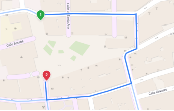
Area routing in Valhalla: comparing algorithms to cross open spaces
Dieser Monat war extrem stressig für mich und ich muss pendeln und kann daher nicht zum Stammtisch. Nächstes Mal bin ich aber wieder dabei. Viel Spaß an alle die zum Stammtisch gehen.
Please help me raise funds to purchase the missing sheets from the complete historical 1:50,000 topographic map series of Zimbabwe, formerly Rhodesia.
If you use the amazing better-osm-org browser extension/userscript to review changesets, you are probably familiar with its default red, green, and yellow diff highlighting.
As I had mentioned in my last post where I explain what they are, I had long planned to make a video about mapping historic lifting stones.