Kilka słów o postępie w nauce, 8 lutego 2026 roku
- Dodawanie zakresów mieszkań tagiem addr:flats jest tylko informacyjne. Nie pomaga to niestety w nawigacji i możliwości wpisywania adresów z numerem mieszkań do prowadzenia przez nawigację. Stanowi jednak dobry wstęp by w przyszłości “rzeźbić” samemu każde mieszkanie lub by ktoś inny się tego podjął.
- To dziwne, że nie było automatu Pocztex zaznaczonego na osiedlu Zygmunta starego. InPost, DPD czy one box są dobrze oznaczone w całym mieście, jednak tutaj niezweryfikowane podejrzenia iż to się zaczytuje automatycznie.
- Podejrzewam, że OSM jest traktowane po macoszemu przez wszystkich. Szczególnie tych, którzy korzystają z tego nieświadomie. Ma to swoje zalety - udało mi się jako pierwszemu dodać dwa urządzenia będące recyklomatami na mapie OSM dla Poznania.

The seriousness with which the OpenStreetMap community approaches discussions is a true strength of the project. Over years of debate, the community has formed a highly cohesive tagging system for names.
https://en.wikipedia.org/wiki/Akkadian_Empire
https://en.wikipedia.org/wiki/Ebla#/media/File:Ancient_Near_East_2400BC.svg
https://en.wikipedia.org/wiki/Bell_Beaker_culture
https://en.wikipedia.org/wiki/Ebla
https://en.wikipedia.org/wiki/Ebla#/media/File:Ancient_Near_East_2400BC.svg
https://en.wikipedia.org/wiki/Bell_Beaker_culture
https://en.wikipedia.org/wiki/Ebla
Quick notes for self
https://en.wikipedia.org/wiki/Akkadian_Empire https://en.wikipedia.org/wiki/Ebla#/media/File:Ancient_Near_East_2400BC.svg https://en.wikipedia.org/wiki/Bell_Beaker_culture https://en.wikipedia.org/wiki/EblaOpenStreetMap
Today, I continued my journey as an OpenStreetMap contributor by actively participating in humanitarian mapping through the HOT Tasking Manager. During this session, I focused on mapping basic features such as buildings and road segments using satellite imagery.
This experience helped me better understand the importance of accurate data in supporting humanitarian efforts, including disaster response and community planning. I paid close attention to data quality, proper tagging, and alignment with OpenStreetMap mapping guidelines.
Through this contribution, I strengthened my familiarity with the OSM editing tools and improved my confidence as a mapper. I also gained valuable insight into how collaborative mapping enables volunteers from around the world to support vulnerable communities with reliable geospatial data.
I look forward to continuing my contributions, improving my skills, and participating in more humanitarian mapping projects in the future.
This experience helped me better understand the importance of accurate data in supporting humanitarian efforts, including disaster response and community planning. I paid close attention to data quality, proper tagging, and alignment with OpenStreetMap mapping guidelines.
Through this contribution, I strengthened my familiarity with the OSM editing tools and improved my confidence as a mapper. I also gained valuable insight into how collaborative mapping enables volunteers from around the world to support vulnerable communities with reliable geospatial data.
I look forward to continuing my contributions, improving my skills, and participating in more humanitarian mapping projects in the future.
Jede*r hier hat (ständig wechselnd) andere Prioritäten und alle halten ihren Schwerpunkt immer für den Wichtigsten ;)
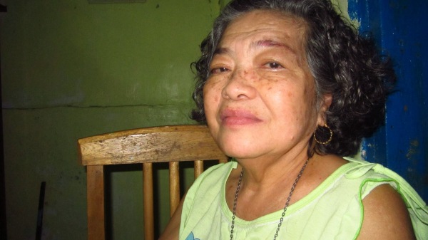
Jovita Fuentes Javellana, age 82, of Acworth, GA, passed away on Thursday, February 7, 2019. She was born on June 24, 1936 in Iloilo, Barotac Nuevo in the Philippines to Angelina Agudo and Nicolas Fuentes. We call her by her name, Betty.
im sooo new plssss what can i benefit from this, i needddd this to help me for the future and stuff idk
Model buildings along the grid, after each grid add accessible parking and crosswalks, levels, addresses, alltheplaces, and wikimaps, then adjust roads and add streetside and zoning. I will later add lanes
add street lamps, check sidewalks, and add street signs and fences
add businesses ect.
survey area to find missing details
add neighborhoods to Evansville, each added once that neighborhood is complete
add neighborhoods to Newburgh, likely no borders only points
add street lamps, check sidewalks, and add street signs and fences
add businesses ect.
survey area to find missing details
add neighborhoods to Evansville, each added once that neighborhood is complete
add neighborhoods to Newburgh, likely no borders only points
In disasters and other connectivity outages, people on the ground often see road blockages, landslides, bridge damage, or other map-relevant changes before reliable Internet access is restored.
Occasionally, I simply scroll through the map on openstreetsmap.org.
A year ago, I became aware of the area around Sa Pobla, a Spanish town on the Balearic island of Mallorca.
A year ago, I became aware of the area around Sa Pobla, a Spanish town on the Balearic island of Mallorca.
Not everything in the woods needs a map, and not everything needs to be publicly accessible online. Enter the woods, make your own maps, and share them with the friends that are willing to conserve and enjoy the land as they should.
Starting in 2026, I slightly adjusted my daily routine, particularly around my weeklyOSM-related activity. Instead of passively consuming updates, I began actively scanning for news by lurking in several regional OSM online groups.
At SOTM EU I gave a demo of how to use the OSMF vector tiles with custom tiles for detailed information on a feature. In the demo I showed walls, focusing on the material of the walls.
I fell down the rabit hole, learning about OSM, in order to port the map into a video game called Farm Simulator. They suggested I just rip it, and add what I want unsaved before I port, then realized I might as well just contribute to this neat open source database! I actually find it quite satisfying, and hope I’m helping. I’m not sure how long I’ll stick around, but I’m already at the max contribution…
The weather’s not been great around here, so I’m keeping myself busy (and out of harms way) by updating OpenStreetMap – there are lots of missing buildings here and there, and a few missing pathways and trails.
I’ve been focusing on the Ely, Caeru, and St Fagans areas in Cardiff as I’ve a particular interest in their history (see my previous posts). My aim is to add more detail to the woodland areas, especially the locations of hidden historical sites and secluded trails.
There are lots of buildings throughout that also need re-aligning, with the last edit for many being sixteen years prior! I’ll continue to chip away until everything’s up to date – given the horrid weather, I shouldn’t run short on time!
I’ve been focusing on the Ely, Caeru, and St Fagans areas in Cardiff as I’ve a particular interest in their history (see my previous posts). My aim is to add more detail to the woodland areas, especially the locations of hidden historical sites and secluded trails.
There are lots of buildings throughout that also need re-aligning, with the last edit for many being sixteen years prior! I’ll continue to chip away until everything’s up to date – given the horrid weather, I shouldn’t run short on time!
Around the Houses!
The weathers not been great around here, so Im keeping myself busy (and out of harms way) by updating OpenStreetMap there are lots of missing buildings here and there, and a few missing pathways and trails.OpenStreetMap
I’ve been editing and modifying things on OpenStreetMap for about a year now, which is just insane to me!
I had never thought I’d make it to this point. At first, I was trying to modify a village and make it look a little better, but now, I can modify a lot of places.
If I showed my account to myself a year ago, he wouldn’t believe me.
Of course, this is still not my job. I’m still incredibly busy with life, which might make it harder for me to modify things on this platform, but I still enjoy my time here!
Thank you, guys, for reading this! I really appreciate your time here!
Peace.
I had never thought I’d make it to this point. At first, I was trying to modify a village and make it look a little better, but now, I can modify a lot of places.
If I showed my account to myself a year ago, he wouldn’t believe me.
Of course, this is still not my job. I’m still incredibly busy with life, which might make it harder for me to modify things on this platform, but I still enjoy my time here!
Thank you, guys, for reading this! I really appreciate your time here!
Peace.
- Emerucha
I've been on OpenStreetMap for about a year now!
Ive been editing and modifying things on OpenStreetMap for about a year now, which is just insane to me!OpenStreetMap
Things you only find in OSM no 94...
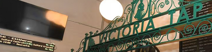
e.g. A place called “FooBar” should show up when you search for “Foo Bar”, or “Foo & Bar’s” should appear for “Foo and Bars”.
Note the space, ampersand, and apostrophe which may affect a search engine but are not pronounced in spoken English.
Is there a tag that the search engines pick up where I can put those variations? I notice that CoMap’s search engine is pretty good, but the search on openstreetmap.org is a little more strict.
Note the space, ampersand, and apostrophe which may affect a search engine but are not pronounced in spoken English.
Is there a tag that the search engines pick up where I can put those variations? I notice that CoMap’s search engine is pretty good, but the search on openstreetmap.org is a little more strict.
Can I add extra keywords to improve search results?
e.g. A place called FooBar should show up when you search for Foo Bar, or Foo & Bars should appear for Foo and Bars.OpenStreetMap
Exactly a year ago I summed up the results in diary of my work on the script, its time to do it again.
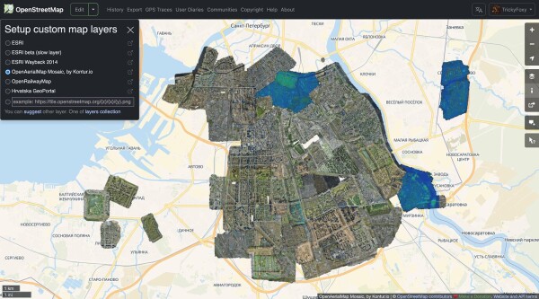
I just created OpenMediaMap, an openly-editable map of old photo (pre-1930) locations.
Model buildings along the grid, after each grid add accessible parking and crosswalks, levels, addresses, alltheplaces, and wikimaps, then adjust roads and add streetside
add street lamps, check sidewalks, and add street signs and fences
add businesses ect.
survey area to find missing details
add neighborhoods to Evansville, each added once that neighborhood is complete
add neighborhoods to Newburgh, likely no borders only points
add street lamps, check sidewalks, and add street signs and fences
add businesses ect.
survey area to find missing details
add neighborhoods to Evansville, each added once that neighborhood is complete
add neighborhoods to Newburgh, likely no borders only points
For the German regions of Sachsen-Anhalt and Niedersachen, I thought there are probably all buildings mapped. At least those called Einfamilienhaus or Reihenhaus.
But I found that with the following overPass query, many potential spots for missing buildings data can be found:
way["landuse"="construction"]({{bbox}});
And because of that my change set statistics of today is as follows:
Many buildings have been added (and some trees 🌳👼) in Niedersachsen and Sachsen-Anhalt.
But as the query suggests, there are still some construction sites which can be investigated. Probably this “trick” is already known to hardcore-mapper ;)
But I found that with the following overPass query, many potential spots for missing buildings data can be found:
way["landuse"="construction"]({{bbox}});
And because of that my change set statistics of today is as follows:
Edited on 2026-01-27:
- 2281 nodes
- 404 ways
- 1 relation
Most used tags for nodes:
natural(371)addr:housenumber(48)addr:street(48)addr:postcode(46)addr:city(46)entrance(36)addr:country(26)
Most used tags for ways:
building(319)landuse(22)highway(16)amenity(9)addr:postcode(9)addr:city(9)
Conclusion
Many buildings have been added (and some trees 🌳👼) in Niedersachsen and Sachsen-Anhalt.
But as the query suggests, there are still some construction sites which can be investigated. Probably this “trick” is already known to hardcore-mapper ;)
এই ম্যাপিং কার্যক্রমে রাজশাহী জেলার বাগমারা উপজেলার নাগা বাজার এলাকাকে কেন্দ্র করে মাঠপর্যায়ের তথ্য ব্যবহার করে OpenStreetMap হালনাগাদ করা হয়েছে। এতে নাগা বাজারের নিকট অবস্থিত একটি ইসলামি শিক্ষা প্রতিষ্ঠান (মাদ্রাসা), অবস্থান ও প্রাসঙ্গিক ট্যাগ যুক্ত করা হয়েছে, যা স্থানীয় শিক্ষার্থী ও পথচারীদের জন্য সহায়ক হবে।
নাগা বাজার সংলগ্ন ইসলামি শিক্ষা প্রতিষ্ঠান যুক্তকরণ
এই ম্যাপিং কার্যক্রমে রাজশাহী জেলার বাগমারা উপজেলার নাগা বাজার এলাকাকে কেন্দ্র করে মাঠপর্যায়ের তথ্য ব্যবহার করে OpenStreetMap হালনাগাদ করা হয়েছে। এতে নাগা বাজারের নিকট অবস্থিত একটি ইসলামি শিক্ষা প্রতিষ্ঠান (মাদ্রাসা), অবস্থান ও প্রাসঙ্গিক ট্যাগ যুক…OpenStreetMap
Second day of quick weekend project.
Frankly, I’ve run out of interesting things to map around my immediate surroundings.
Frankly, I’ve run out of interesting things to map around my immediate surroundings.
Today, uBlock Origin detected 2 trackers. There was an attempt to fingerprint my GPU by extracting canvas data. What is going on, OSM? Is this why I’ve been donating you my free time? Maybe you’re not so better than Google after all…
A Mapathon has been organised for Saturday 21st February 2026 from 11am to 1pm in Belfast. Pizza will be provided at QUB Geosciences building on Elmwood Avenue behind the Student’s Union. Numbers are limited to 30 attendees.

I have been trying to mark my business on openstreetmap
it is already there on google maps. I have a question if anyone can answer please.
it is already there on google maps. I have a question if anyone can answer please.

Ive dabbled with overpass turbo on and off for maybe a year now, but I feel like Ive just now started to get a better understanding of how it works.
Ive been using it to find hikes that can lead to ruins or abandoned places:
Ive been using it to find hikes that can lead to ruins or abandoned places:


Zabieram się za dodawanie i poprawianie nazw przystanków według uchwał przystankowych konkretnych gmin w Powiecie Koszalińskim.
Rafał 🇵🇱🇺🇦🇲🇽🇩🇰🇬🇱🇪🇺 lubi to.
2 użytkowników udostępniło to dalej
Spółka wykreślona z KRS to nie koniec obowiązków! Dokumenty (kadrowe, księgowe) muszą być przechowywane nawet 5-10 lat po likwidacji.
Brak archiwum = problemy podczas kontroli US czy ZUS.
Konieczne jest formalne wyznaczenie osoby odpowiedzialnej w uchwale.
Join Poland organizuje i zabezpiecza obowiązek archiwizacyjny. Wyeliminuj ryzyko po zamknięciu firmy.
Brak archiwum = problemy podczas kontroli US czy ZUS.
Konieczne jest formalne wyznaczenie osoby odpowiedzialnej w uchwale.
Join Poland organizuje i zabezpiecza obowiązek archiwizacyjny. Wyeliminuj ryzyko po zamknięciu firmy.

Martina Neumayer lubi to.
Martina Neumayerudostępnił to.
I joined the Humanitarian OpenStreetMap Team with a simple interest in mapping, not fully aware of how profoundly it would shape my personal journey and the growth of the OSM Kenya community.

The page contains all OSM data for the period up to 2026-01-14

মৌলভিভিটা (Mulivita) হলো বাগমারা উপজেলার একটি মুসলিম সম্প্রদায়ের স্মৃতিবিজড়িত স্থান, যা নাগা বাজারের নিকট অবস্থিত। স্থানটি ঐতিহাসিক ও সামাজিক গুরুত্ব বহন করে এবং স্থানীয়দের কাছে স্মৃতিস্তম্ভ হিসেবে পরিচিত।

Earlier this week, I accepted a PR to our codebase that made a bad and duplicated phone numbers. What happened was, that we use contact:phone=* per convention, but many entries used phone=*, which was not detected by our dupe scanner.

I’ve run into a strange behaviour in my OSM user diary entry when documenting a batch/ffmpeg command.

Martina Neumayer
•