To help make OSM more inclusive in line with the diversity statement https://osmfoundation.org/wiki/Diversity_Statement I’ve gone through the wiki and changed all relevant instances of specific pronouns to their gender neutral versions.

OSM Inclusivity
To help make OSM more inclusive in line with the diversity statement https://osmfoundation.org/wiki/Diversity_Statement I’ve gone through the wiki and changed all relevant instances of specific pronouns to their gender neutral versions.OpenStreetMap
Myanmar Earthquake 2025 - Bago Township Roads and Buildings Mapping Toady 200 edit Mapping Contribution done
Happy to be part of the Esri India User Conference—a great opportunity to learn new trends, attend practical sessions, and connect with industry experts and scientists. Grateful to my organization Jio-bp and my lead for giving me this chance to represent at the Esri India User Conference.
Take a look to watch they on the outside it ain’t safe to watch look alive
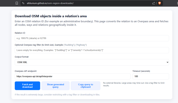
I’ve been mulling over an idea for a while: what if we grab a complete snapshot of OpenStreetMap data for a given region, then run some statistics over it?
This report reflects on my journey during Google Summer of Code 2025, where I worked on the 3D Model Repository (3DMR): a platform that makes high-quality, CC-licensed 3D assets discoverable, reusable, and directly linkable to OpenStreetMap (OSM) fea…
y first day in mapping was sweet and exciting. I felt good to know that even small tasks I did could help improve global maps. It was interesting to discover how roads, buildings, and other features are added, and I enjoyed learning while contributing to something meaningful. That experience motivated me to keep mapping and to grow my skills further.
Hello OSM friends! I’m Bhausaheb…… from Nashik, working in GIS Industry as an GIS Engineer. Recently, I have been mapped new buildings around my locality using ID Editor.
My story of mapping and detailing my dead town

My story of mapping and detailing my dead town
(My first diary entry, am I doing this right?)OpenStreetMap
Hello OSM friends! I’m Pratap from Mumbai, working in GIS. Recently, I mapped new buildings in my locality using iD editor and did QA checks with OSM Inspector. I’m excited to share my learning with the community
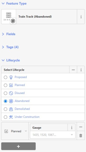
Lifecycle tagging is the representation of the temporal state of an object (e.g., whether it is under construction, demolished, or abandoned).
Luis Aguilar 7, Modelo
Matamoros, Tamaulipas
(868) 812-1327
Matamoros, Tamaulipas
(868) 812-1327

Módulo de Atención Católica a Migrantes
Luis Aguilar 7, Modelo Matamoros, Tamaulipas (868) 812-1327OpenStreetMap
Albergue
49 Calle Golfo de México, Colonia Ampliación Solidaridad Matamoros, Tamaulipas, 87453 Mexico (868) 822-2213
Servicios proporcionados: Alimentos, hospedaje, primeros auxilios, acompañamiento médico, asesoría jurídica, asesoría psicológica
49 Calle Golfo de México, Colonia Ampliación Solidaridad Matamoros, Tamaulipas, 87453 Mexico (868) 822-2213
Servicios proporcionados: Alimentos, hospedaje, primeros auxilios, acompañamiento médico, asesoría jurídica, asesoría psicológica
Módulo de Repatriación Humana Calle Puente Matamoros, Jardín, 87330 Matamoros, Tamps., Mexico +52 868 812 0709
This is where the US CBP/ICE drops off previously detained Mexican citizens.
This is where the US CBP/ICE drops off previously detained Mexican citizens.

Módulo de Repatriación Humana
Módulo de Repatriación Humana Calle Puente Matamoros, Jardín, 87330 Matamoros, Tamps., Mexico +52 868 812 0709OpenStreetMap
SIWES Diary – Day 1
Date: 2nd September, 2025
Organization: Unique Mappers Network, Nigeria
National Office: Suite 7, Mapathon Center, UNIPORT Mall, Abuja Campus, University of Port Harcourt
Date: 2nd September, 2025
Organization: Unique Mappers Network, Nigeria
National Office: Suite 7, Mapathon Center, UNIPORT Mall, Abuja Campus, University of Port Harcourt
Der Datensatz WMS LGL-BW ALKIS enthält liegenschaften und Hausnummern.
In 2025 alone I found vandalism incidents specifically targeting map of Indonesian parliament compound twice, in March and now in late August. Thankfully these are all restored.
What made me sad that some Indonesians don’t understand the OpenStreetMap at all, what they only know in their head is political activism. They do by erasing - or editing - the place of institution they despise. Not really sure if these incidents are unique to maps in Indonesia or there’s international example of politically motivated vandalism of OSM maps?
What made me sad that some Indonesians don’t understand the OpenStreetMap at all, what they only know in their head is political activism. They do by erasing - or editing - the place of institution they despise. Not really sure if these incidents are unique to maps in Indonesia or there’s international example of politically motivated vandalism of OSM maps?
Styles for vector tiles are typically written in the MapLibre GL style language. These definitions exist in JSON, which, for various reasons, is not a good language for humans to write in.
OSM Accounts
same login:https://wiki.openstreetmap.org/wiki/User:XXX
https://community.openstreetmap.org/u/XXX
different login:
https://www.openstreetmap.org/user/XXX
Integrations:
Services
- Github
- Umap
- Facilmap
- Overpass
- Geojson.io
Desktop Applications
- josm
- gnome-maps
Android Applications
… TODO
Wenn mal nicht klar ist was gemacht wurde die folgende Url nutzen und die Changeset ID am ende anhägen:
Hi everyone, this is the update on the final phase of my project in adding transliteration support to Nominatim’s search results! A quick refresher: this project focused on adding transliteration as an option to users who did not understand the local…
Hi everyone, this is the update on the final phase of my project in adding transliteration support to Nominatim’s search results! A quick refresher: this project focused on adding transliteration as an option to users who did not understand the local…
This report reflects on my journey during Google Summer of Code 2025, where I worked on the 3D Model Repository (3DMR): a platform that makes high-quality, CC-licensed 3D assets discoverable, reusable, and directly linkable to OpenStreetMap (OSM) fea…
OSM exists now since more than 20 years. During this time, a tagging scheme evolved. It has undergone several changes since, is partly approved by the community, but never anything was forced.
I once walked past a small building, spotted that its got an address, and added it to OSM. Then I walked past it again, the building had its facade updatedand the address was nowhere to be seen.
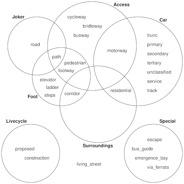
I have noticed that the Apple mapping team, in their work within Kazakhstan, consistently mismapped various highway=* ways, for example:
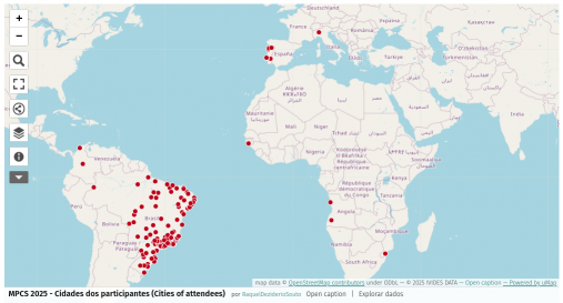
Attendees cities of the MPCS 2025 | Cidades dos inscritos no MPCS 2025
A few bike lanes were added in the part of town I live in (yay!) and I’d like to add them.
However, I’ve mostly been using these apps to map things: * everydoor * map complete website * go map !! (rarely)
I cant find any way in map compete to add bike lanes – they added on the street, so effectively making the space for the cars narrower. Is there any simple way of going about and adding these types of lanes?
Thanks!

Easy way to add bike lanes?
A few bike lanes were added in the part of town I live in (yay!) and Id like to add them.OpenStreetMap
Id like to share a simple method Ive devised to map unfamiliar areas outdoors. Suppose youd like create a GPX track of a park under the following constraints:
Final Submission - Temporary Road Closures Database and API - GSOC 2025
Final Submission - Temporary Road Closures Database and API - GSOC 2025
Google Summer of Code 2025 • OpenStreetMap Foundation • Archit RathodOpenStreetMap
( kilka - kilkadziesiąt metrów, bez wody / PL: 1-2.5 m szer. i mniej)) https://wiki.openstreetmap.org/wiki/Pl:Tag:natural%3Dgully

ZBOCZA, SKARPY, WĄWOZY, DOLINY, ŻLEBY
( kilka - kilkadziesiąt metrów, bez wody / PL: 1-2.5 m szer. i mniej)) https://wiki.openstreetmap.org/wiki/Pl:Tag:natural%3DgullyOpenStreetMap


























![Apple Data Team *destructive* to road mapping?[1]](https://soc.citizen4.eu/photo/preview/600/3835382)
