Looking back at my OpenStreetMap journey, two dates will always hold a very special place in my heart—June 21 and October 14.
On June 21, I achieved something I had been working toward for a long time: I became the top mapper in KU Youth Mappers. That moment felt surreal. From the days when I was just learning how to draw my first building on the map to reaching the top position—it was a journey filled with patience, consistency, and continuous learning. Every late night of mapping, every small correction, and every effort finally felt worth it.
But the journey didn’t stop there.
On October 14, I reached another incredible milestone—I became a top mapper in UN Mappers. This achievement felt even bigger, as it connected my work to a global level. Contributing alongside mappers from around the world and being recognized among them made me realize how far I had come.
These milestones are not just about rankings or titles. They represent growth, dedication, and the impact of consistent effort. From starting out as a beginner to becoming a leading contributor in both university and international communities, my journey has transformed me—not just as a mapper, but as a learner and contributor.
Sometimes I pause and think about how it all started with simple curiosity. And now, those small steps have led to achievements I once never imagined.
This journey reminds me that with passion and persistence, even the smallest edits can lead to the biggest milestones.
On June 21, I achieved something I had been working toward for a long time: I became the top mapper in KU Youth Mappers. That moment felt surreal. From the days when I was just learning how to draw my first building on the map to reaching the top position—it was a journey filled with patience, consistency, and continuous learning. Every late night of mapping, every small correction, and every effort finally felt worth it.
But the journey didn’t stop there.
On October 14, I reached another incredible milestone—I became a top mapper in UN Mappers. This achievement felt even bigger, as it connected my work to a global level. Contributing alongside mappers from around the world and being recognized among them made me realize how far I had come.
These milestones are not just about rankings or titles. They represent growth, dedication, and the impact of consistent effort. From starting out as a beginner to becoming a leading contributor in both university and international communities, my journey has transformed me—not just as a mapper, but as a learner and contributor.
Sometimes I pause and think about how it all started with simple curiosity. And now, those small steps have led to achievements I once never imagined.
This journey reminds me that with passion and persistence, even the smallest edits can lead to the biggest milestones.
**Diary Entry: Milestones That Defined My Mapping Journey**
Looking back at my OpenStreetMap journey, two dates will always hold a very special place in my heart—June 21 and October 14.OpenStreetMap

OpenStreetMap is a map of the world, created by people like you and free to use under an open license.
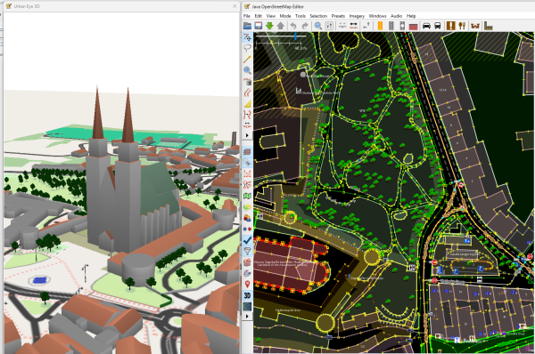
A future version of the UrbanEye3D plugin will support trees and other objects.
Hello people, I’ve been Hoping to help my local town of Exeter and nearby plymouth, ive so far made houses in both sherford and torpoint, ive also named the schools of Clyst vale and Stoke hill, And im hoping to do more to help the community of OpenStreetMap
-SouthWestTrains1
-SouthWestTrains1
My Hopyfully Helpful Contribuations
Hello people, Ive been Hoping to help my local town of Exeter and nearby plymouth, ive so far made houses in both sherford and torpoint, ive also named the schools of Clyst vale and Stoke hill, And im hoping to do more to help the community of OpenSt…OpenStreetMap
Ihr wisst ja, ich hab einen OpenStreetMap-Fetisch :)
Schon sehr lange trage ich gemeinsam mit der Schweizer OSM-Community die Idee rum, dass die ~2000 erfassten Gemeindegrenzen in OpenStreetMap besser gepflegt werden sollten.
Schon sehr lange trage ich gemeinsam mit der Schweizer OSM-Community die Idee rum, dass die ~2000 erfassten Gemeindegrenzen in OpenStreetMap besser gepflegt werden sollten.

Westhay Moor & Honeygar Farm:
https://www.openstreetmap.org/#map=16/51.19215/-2.78186
https://www.openstreetmap.org/#map=16/51.19215/-2.78186
Bogs, reed beds and wetlands
Westhay Moor & Honeygar Farm: https://www.openstreetmap.org/#map=16/51.19215/-2.78186OpenStreetMap
Erste Schritte
Ich habe gerade diese Funktion entdeckt. Und eigentlich klingt es nach einer tollen Idee, meine Ausflüge in einem persönlichen Blog zu dokumentieren. Vielleicht freue ich mich ja eines Tages, wenn ich das hier lese ^^

Ostatnio zauważyłem, że styl OSM Americana nie wyświetla w szczególny sposób numerów dróg wojewódzkich, w przeciwieństwie do dróg krajowych, w tym dróg ekspresowych i autostrad, co zgadza się z definicją, a raczej jej brakiem.

Hello
I have been using OpenStreetMaps for navigation across the globe for multiple years free of charge. I think the time has come for me to give something back to this community.
Thank you wonderful people at OpenStreetMap for such a wonderful project! I hope my contributions will help.
Kind regards
The Vilnius Stroller
I have been using OpenStreetMaps for navigation across the globe for multiple years free of charge. I think the time has come for me to give something back to this community.
Thank you wonderful people at OpenStreetMap for such a wonderful project! I hope my contributions will help.
Kind regards
The Vilnius Stroller

Ive been mapping crosswalk corners using a single point for the curb (lowered or otherwise) on a small spur connecting the sidewalk to the crossing way, trying to balance:
- One entity per feature (not duplicating the curb)
- Not blocking the sidewal…
- One entity per feature (not duplicating the curb)
- Not blocking the sidewal…

I am happy to annouce that, after a long time we, the OpenStreetMap Carto maintainers, have prepared a new major release of the OpenStreetMap Carto stylesheet (the default stylesheet on the OSM website). Once changes are deployed on openstreetmap.
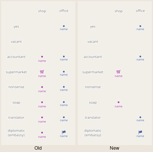
Wasn't it just yesterday that Android 13 was shiny and new? (Missing backgrounds on Android devices)
Wasn't it just yesterday that Android 13 was shiny and new? (Missing backgrounds on Android devices)
Android 13 was released in August 2022, not yesterday, but on the other hand not so long ago.OpenStreetMap
After 3+ weeks of silence following the RFC discussion (no further comments/objections), the proposal is now officially in Voting Phase!

Rail trails with route relations with railway=abandoned to denote a rail trail is not working. When the named bike route enters city streets or along side walks where the railroad never went this becomes and tagging nightmare.

This is not about the Linux Foundations Overture Maps attempt to hoodwink the Open Geospatial Consortium into standardising Overtures GERS (Global Entity Reference System) .

Today I received an invitation to attend the bi-monthly OSM US Maintainers Working Group.
But due to timezone difficulties, I don’t think I’ll be able to attend it live.
The meeting agenda has been shared, mainly focusing on the topic of standards and interoperability. There are some interesting starter questions there, so I’m intrigued to answer those questions in an OSM diary instead, hoping that I’ll be able to join the discussion asynchronously.
So, here we go :
I frequently use GeoJSON format in several of my projects.
GeoJSON fits pretty much all of my required use cases. My only concern right now is how to make GeoJSON files more compact. I haven’t researched much about this since there’s currently no urgent performance issue that needs to be handled, but I love tweaking my apps for performance.
The General Transit Feed Specification.
I’ve been interested in this data format for a long time, but I still don’t know how to properly tinker with it. Last time I worked on this, I had to make my own Python implementation to read and navigate GTFS files. I don’t know what the current situation is right now. Maybe it’s already supported, maybe not.
I already posted my thoughts in a certain Slack thread somewhere. Here’s the verbatim quote:
“Does an OGC standard become legally binding worldwide or something?
I’ve been thinking for quite some time about the idea of having a single global geographic identifier for every place. Ideally, any online content that refers to a location — whether a blog post, tweet, video, or photo — would include that global GeoID so it could be reverse-searched more effectively, such as finding every piece of content that references a specific place. For now, I use OpenStreetMap node, way, or relation IDs as links whenever I mention a place as a rough workaround, but I still hope that vision could be developed further.”
I guess maintainers would only care about standards if those standards personally affect their lives (their projects depend on them).
One day, a certain still-popular web APIs were unilaterally deprecated by a certain majority market-share holder browser company. Several maintainers (me included) staged a protest on their mailing list, practically begging them not to cut our collective lifeline. A representative from that company personally told me a quick fix on how to navigate that situation, and I’ve been using that quick fix for years. I don’t know the rest of the story, but if my app is occasionally broken without a clear reason, I suspect that quick fix is no longer enough to resolve the deprecation issue. That was the last time I participated in a “standardization” discussion.
Not exactly my project per se, but several weeks ago I saw someone in an OSM diary who recommended SCEE as one of the best available OSM editors on mobile. So lately, I’ve tried doing field mapping with SCEE.
They were right, it’s so good.
But somehow preset tags are still missing (I can’t add ATM, recycling center, or power pole yet). I don’t know how to add new preset tags to the app. Is there a hidden menu somewhere, or should we make a pull request to the repository? I’m now quite interested in this topic.
But due to timezone difficulties, I don’t think I’ll be able to attend it live.
The meeting agenda has been shared, mainly focusing on the topic of standards and interoperability. There are some interesting starter questions there, so I’m intrigued to answer those questions in an OSM diary instead, hoping that I’ll be able to join the discussion asynchronously.
So, here we go :
“What standards (geospatial file or data formats, metadata schemas, wire protocols, structured text formats, encodings, etc.) does your project depend on or interact with?”
I frequently use GeoJSON format in several of my projects.
“Are there any standards that you wish would be evolved/extended but aren’t actively maintained? Or implementations that aren’t fully compliant that you wish would be?”
GeoJSON fits pretty much all of my required use cases. My only concern right now is how to make GeoJSON files more compact. I haven’t researched much about this since there’s currently no urgent performance issue that needs to be handled, but I love tweaking my apps for performance.
“Are there standard formats or protocols that you would like to use, but aren’t well supported in your language/ecosystem?”
The General Transit Feed Specification.
I’ve been interested in this data format for a long time, but I still don’t know how to properly tinker with it. Last time I worked on this, I had to make my own Python implementation to read and navigate GTFS files. I don’t know what the current situation is right now. Maybe it’s already supported, maybe not.
“What are your thoughts on Overture’s OGC proposal?”
I already posted my thoughts in a certain Slack thread somewhere. Here’s the verbatim quote:
“Does an OGC standard become legally binding worldwide or something?
I’ve been thinking for quite some time about the idea of having a single global geographic identifier for every place. Ideally, any online content that refers to a location — whether a blog post, tweet, video, or photo — would include that global GeoID so it could be reverse-searched more effectively, such as finding every piece of content that references a specific place. For now, I use OpenStreetMap node, way, or relation IDs as links whenever I mention a place as a rough workaround, but I still hope that vision could be developed further.”
“What role do you think maintainers in the OSM community should play in giving feedback on or submitting standards to formal bodies like OGC?”
I guess maintainers would only care about standards if those standards personally affect their lives (their projects depend on them).
One day, a certain still-popular web APIs were unilaterally deprecated by a certain majority market-share holder browser company. Several maintainers (me included) staged a protest on their mailing list, practically begging them not to cut our collective lifeline. A representative from that company personally told me a quick fix on how to navigate that situation, and I’ve been using that quick fix for years. I don’t know the rest of the story, but if my app is occasionally broken without a clear reason, I suspect that quick fix is no longer enough to resolve the deprecation issue. That was the last time I participated in a “standardization” discussion.
“Anything new with your project(s) you’d like to share?”
Not exactly my project per se, but several weeks ago I saw someone in an OSM diary who recommended SCEE as one of the best available OSM editors on mobile. So lately, I’ve tried doing field mapping with SCEE.
They were right, it’s so good.
But somehow preset tags are still missing (I can’t add ATM, recycling center, or power pole yet). I don’t know how to add new preset tags to the app. Is there a hidden menu somewhere, or should we make a pull request to the repository? I’m now quite interested in this topic.

Finished adding villages in Nagqu City with Tibetan names listed in the Place Names Database KNAB and having a Q-id in wikidata; Im continuing with Ngari Prefecture.

Tonight I finished mapping Maud, meaning the bulk of Fairview California is mapped. There are still some places along Fairview Avenue as it goes around in a circle and becomes Hayward but this is area shared by Hayward, Castro Valley and Fairview.
It feels so good to see my home there and recognizable.
I started this project in earnest on November 18th (although I did my own street back in June).
It feels so good to see my home there and recognizable.
I started this project in earnest on November 18th (although I did my own street back in June).

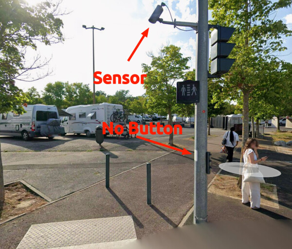
Automatic Pedestrian Detection at Signalized Crossings
Automatic Pedestrian Detection at Signalized Crossings
Author: Derlamaer Date: 18 February 2026OpenStreetMap
Die Strasse L170 von Göschweiler hört bei Schattenmühle auf. Diese sollte meiner Meinung nach weitergehen bis zur Strassenmündung K6516. Ich bin nicht zu 100% sicher, kann das jemand überprüfen und gegebenenfalls korrigieren.

Vibe coding an OSM / Overture conflation tool.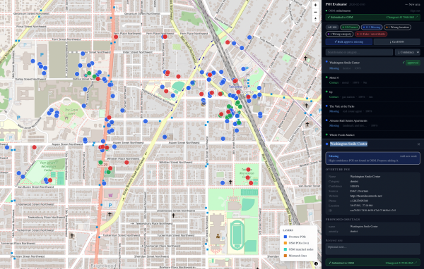
Vibe coding an OSM / Overture conflation tool.
From the Build Plan developed with ClaudeOpenStreetMap
In May 2025 the OSM website introduced two new optional fields in user profiles: company and location.

Until recently, I mainly used the opening_hours evaluation tool to quickly generate valid OSM opening hours. However, it often requires some manual work to simplify the syntax afterwards.
Holux M-241, week rollover fixed with mtkbabel

I have created a tag, diet:excipient_free=* , which is about finding clean supplements, i.e., without harmful ingredients that can make us infertile, inflamed, obese or even epileptic.
For example, whenever we look for magnesium (bis)glycinate, we want one thing, but many so-called “magnesium” supplements come with a lot more ingredients that might reduce the price, or enhance the appearance, but of course, at a cost; to hurt and make us need another supplement to compensate with the side effects. (Maybe they should rename those “magnesium” supplements to corn syrup supplements instead.)
Almost if not all of those ingredients fall into one category, excipients. Let’s use diet:excipient_free=* on pharmacies and nutrition supplement stores to promote a healthier future without dyes, fillers, flavorants, preservatives and other inactive ingredients that can cost us our health.
For example, whenever we look for magnesium (bis)glycinate, we want one thing, but many so-called “magnesium” supplements come with a lot more ingredients that might reduce the price, or enhance the appearance, but of course, at a cost; to hurt and make us need another supplement to compensate with the side effects. (Maybe they should rename those “magnesium” supplements to corn syrup supplements instead.)
Almost if not all of those ingredients fall into one category, excipients. Let’s use diet:excipient_free=* on pharmacies and nutrition supplement stores to promote a healthier future without dyes, fillers, flavorants, preservatives and other inactive ingredients that can cost us our health.

OpenStreetMap old timers know about the infamous 2009 TIGER import of road data in the US that continues giving to this day.

3 March 2026: Writing this a Missing Maps “London” remote meeting, realizing that I’d never written a OSM diary about the research I did within the ecosystem. I’m so late! But I’d love to still write this down.
2019 - 2022: Anthropologist perspectives on OpenStreetMap
3 March 2026: Writing this a Missing Maps London remote meeting, realizing that Id never written a OSM diary about the research I did within the ecosystem. Im so late! But Id love to still write this down.OpenStreetMap
I started a new wiki talk page discussion on the conflicting/controversial usage of the wetland=tidalflat tag regarding implied and explicit surface types:


Every map tells a story.
Some stories are drawn with roads and buildings. Others are written through people, voices, and lived experiences.
Some stories are drawn with roads and buildings. Others are written through people, voices, and lived experiences.
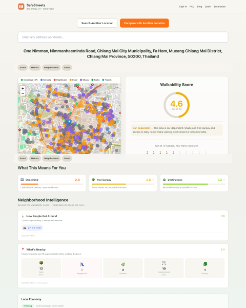
Nimman Road, Chiang Mai(Thailand) is a well-mapped, high-traffic corridor. It scores a B on network density: good intersection frequency, reasonable block lengths.
Portal North Bridge construction and study documents

Manchmal sind es die kleinen Details. Dank 360° Mapillary Bildern konnte ich an der Stelle die Gegend etwas aufhübschen. Auch wenn man natürlich nicht für den Renderer mappen soll. Aber ein paar Dinge sind doch nützlicherweise hinzugekommen.

Hello. Karen and I traveled to Atlanta, GA as part of our revolutionary campaign.
Hello. Karen and I traveled to Atlanta, GA as part of our revolutionary campaign.
Hello. Karen and I traveled to Atlanta, GA as part of our revolutionary campaign.

OK. Last year I wrote a short guide on mapping Indian addresses but I lost it in my tiny pursuit to delete myself.

A few months ago, I worked on a new project: the OSM Tagging Schema MCP — a Model Context Protocol (MCP) server built for AI assistants and LLM applications that interact with OpenStreetMap tagging data.

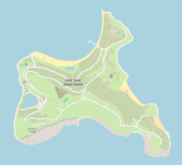
Remapped Little Saint James (epstein's island) [2025 Winter]
finding myself to osm was something I couldn’t understand at the time. Now with an open eye, in my field of water engineering introduced to geographical information system. I love it here my journey begins now mapping take me overseas. 😊

banshee7076
•