I’ve been editing and modifying things on OpenStreetMap for about a year now, which is just insane to me!
I had never thought I’d make it to this point. At first, I was trying to modify a village and make it look a little better, but now, I can modify a lot of places.
If I showed my account to myself a year ago, he wouldn’t believe me.
Of course, this is still not my job. I’m still incredibly busy with life, which might make it harder for me to modify things on this platform, but I still enjoy my time here!
Thank you, guys, for reading this! I really appreciate your time here!
Peace.
I had never thought I’d make it to this point. At first, I was trying to modify a village and make it look a little better, but now, I can modify a lot of places.
If I showed my account to myself a year ago, he wouldn’t believe me.
Of course, this is still not my job. I’m still incredibly busy with life, which might make it harder for me to modify things on this platform, but I still enjoy my time here!
Thank you, guys, for reading this! I really appreciate your time here!
Peace.
- Emerucha
I've been on OpenStreetMap for about a year now!
Ive been editing and modifying things on OpenStreetMap for about a year now, which is just insane to me!OpenStreetMap

Things you only find in OSM no 94...
e.g. A place called “FooBar” should show up when you search for “Foo Bar”, or “Foo & Bar’s” should appear for “Foo and Bars”.
Note the space, ampersand, and apostrophe which may affect a search engine but are not pronounced in spoken English.
Is there a tag that the search engines pick up where I can put those variations? I notice that CoMap’s search engine is pretty good, but the search on openstreetmap.org is a little more strict.
Note the space, ampersand, and apostrophe which may affect a search engine but are not pronounced in spoken English.
Is there a tag that the search engines pick up where I can put those variations? I notice that CoMap’s search engine is pretty good, but the search on openstreetmap.org is a little more strict.
Can I add extra keywords to improve search results?
e.g. A place called FooBar should show up when you search for Foo Bar, or Foo & Bars should appear for Foo and Bars.OpenStreetMap
Exactly a year ago I summed up the results in diary of my work on the script, its time to do it again.
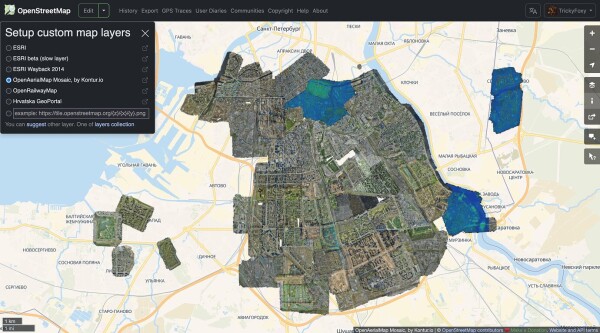
I just created OpenMediaMap, an openly-editable map of old photo (pre-1930) locations.
Model buildings along the grid, after each grid add accessible parking and crosswalks, levels, addresses, alltheplaces, and wikimaps, then adjust roads and add streetside
add street lamps, check sidewalks, and add street signs and fences
add businesses ect.
survey area to find missing details
add neighborhoods to Evansville, each added once that neighborhood is complete
add neighborhoods to Newburgh, likely no borders only points
add street lamps, check sidewalks, and add street signs and fences
add businesses ect.
survey area to find missing details
add neighborhoods to Evansville, each added once that neighborhood is complete
add neighborhoods to Newburgh, likely no borders only points
For the German regions of Sachsen-Anhalt and Niedersachen, I thought there are probably all buildings mapped. At least those called Einfamilienhaus or Reihenhaus.
But I found that with the following overPass query, many potential spots for missing buildings data can be found:
way["landuse"="construction"]({{bbox}});
And because of that my change set statistics of today is as follows:
Many buildings have been added (and some trees 🌳👼) in Niedersachsen and Sachsen-Anhalt.
But as the query suggests, there are still some construction sites which can be investigated. Probably this “trick” is already known to hardcore-mapper ;)
But I found that with the following overPass query, many potential spots for missing buildings data can be found:
way["landuse"="construction"]({{bbox}});
And because of that my change set statistics of today is as follows:
Edited on 2026-01-27:
- 2281 nodes
- 404 ways
- 1 relation
Most used tags for nodes:
natural(371)addr:housenumber(48)addr:street(48)addr:postcode(46)addr:city(46)entrance(36)addr:country(26)
Most used tags for ways:
building(319)landuse(22)highway(16)amenity(9)addr:postcode(9)addr:city(9)
Conclusion
Many buildings have been added (and some trees 🌳👼) in Niedersachsen and Sachsen-Anhalt.
But as the query suggests, there are still some construction sites which can be investigated. Probably this “trick” is already known to hardcore-mapper ;)
এই ম্যাপিং কার্যক্রমে রাজশাহী জেলার বাগমারা উপজেলার নাগা বাজার এলাকাকে কেন্দ্র করে মাঠপর্যায়ের তথ্য ব্যবহার করে OpenStreetMap হালনাগাদ করা হয়েছে। এতে নাগা বাজারের নিকট অবস্থিত একটি ইসলামি শিক্ষা প্রতিষ্ঠান (মাদ্রাসা), অবস্থান ও প্রাসঙ্গিক ট্যাগ যুক্ত করা হয়েছে, যা স্থানীয় শিক্ষার্থী ও পথচারীদের জন্য সহায়ক হবে।
নাগা বাজার সংলগ্ন ইসলামি শিক্ষা প্রতিষ্ঠান যুক্তকরণ
এই ম্যাপিং কার্যক্রমে রাজশাহী জেলার বাগমারা উপজেলার নাগা বাজার এলাকাকে কেন্দ্র করে মাঠপর্যায়ের তথ্য ব্যবহার করে OpenStreetMap হালনাগাদ করা হয়েছে। এতে নাগা বাজারের নিকট অবস্থিত একটি ইসলামি শিক্ষা প্রতিষ্ঠান (মাদ্রাসা), অবস্থান ও প্রাসঙ্গিক ট্যাগ যুক…OpenStreetMap
Second day of quick weekend project.
Frankly, I’ve run out of interesting things to map around my immediate surroundings.
Frankly, I’ve run out of interesting things to map around my immediate surroundings.
Today, uBlock Origin detected 2 trackers. There was an attempt to fingerprint my GPU by extracting canvas data. What is going on, OSM? Is this why I’ve been donating you my free time? Maybe you’re not so better than Google after all…
A Mapathon has been organised for Saturday 21st February 2026 from 11am to 1pm in Belfast. Pizza will be provided at QUB Geosciences building on Elmwood Avenue behind the Student’s Union. Numbers are limited to 30 attendees.

I have been trying to mark my business on openstreetmap
it is already there on google maps. I have a question if anyone can answer please.
it is already there on google maps. I have a question if anyone can answer please.

Ive dabbled with overpass turbo on and off for maybe a year now, but I feel like Ive just now started to get a better understanding of how it works.
Ive been using it to find hikes that can lead to ruins or abandoned places:
Ive been using it to find hikes that can lead to ruins or abandoned places:


Zabieram się za dodawanie i poprawianie nazw przystanków według uchwał przystankowych konkretnych gmin w Powiecie Koszalińskim.
Rafał 🇵🇱🇺🇦🇲🇽🇩🇰🇬🇱🇪🇺 lubi to.
2 użytkowników udostępniło to dalej
Spółka wykreślona z KRS to nie koniec obowiązków! Dokumenty (kadrowe, księgowe) muszą być przechowywane nawet 5-10 lat po likwidacji.
Brak archiwum = problemy podczas kontroli US czy ZUS.
Konieczne jest formalne wyznaczenie osoby odpowiedzialnej w uchwale.
Join Poland organizuje i zabezpiecza obowiązek archiwizacyjny. Wyeliminuj ryzyko po zamknięciu firmy.
Brak archiwum = problemy podczas kontroli US czy ZUS.
Konieczne jest formalne wyznaczenie osoby odpowiedzialnej w uchwale.
Join Poland organizuje i zabezpiecza obowiązek archiwizacyjny. Wyeliminuj ryzyko po zamknięciu firmy.

Martina Neumayer lubi to.
Martina Neumayerudostępnił to.
I joined the Humanitarian OpenStreetMap Team with a simple interest in mapping, not fully aware of how profoundly it would shape my personal journey and the growth of the OSM Kenya community.

The page contains all OSM data for the period up to 2026-01-14

মৌলভিভিটা (Mulivita) হলো বাগমারা উপজেলার একটি মুসলিম সম্প্রদায়ের স্মৃতিবিজড়িত স্থান, যা নাগা বাজারের নিকট অবস্থিত। স্থানটি ঐতিহাসিক ও সামাজিক গুরুত্ব বহন করে এবং স্থানীয়দের কাছে স্মৃতিস্তম্ভ হিসেবে পরিচিত।

Earlier this week, I accepted a PR to our codebase that made a bad and duplicated phone numbers. What happened was, that we use contact:phone=* per convention, but many entries used phone=*, which was not detected by our dupe scanner.

I’ve run into a strange behaviour in my OSM user diary entry when documenting a batch/ffmpeg command.

In order for OpenStreetMap to thrive, we need to attract and retain new mappers. To be welcoming to newcomers, we should avoid high barriers to starting mapping and instead support contributions that can be made with limited time, context, and experi…

In Fall 2024, I broke my radius (arm) at the wrist of my dominant hand, and didn’t map at all for 2 months, gradually picking things up as my arm healed and gained strength. It was agonizing to not have my daily OSM fix - and a palpable relief when my wrist could once again handle an extended session with a mouse.
Not content with my previous mapping outage, in Fall 2025 I had a cancerous tumor in my parotid (cheekbone salivary gland) removed - except that a relatively straightforward 2 hour surgery turned into a 13-hour marathon and an overnight hospital stay ballooned into 8 days in a hospital bed. The cancer had spread to lymph nodes, to one of my jugular veins and into muscle tissue in my neck. Recovery from the surgery turned into immediate chemotherapy + immunotherapy and radiation.
So now I map when I’m able, which unfortunately is not very frequently. My #Mali project gathers dust, with almost all of my current OSM edits focused around related work with my one remaining freelance client. There does appear to be light at the end of the tunnel (I’m pretty sure it’s not a train). My body has responded well to treatment, and there’s talk of moving me off chemo and onto straight immunotherapy. Looking forward to that possibility.
All of this to say: treasure the time you have. If the difference you make is measured in your OSM edits, then by god make those edits. But more importantly, if the difference you make is measured through those around you that are intertwined into your life, make sure you give sufficient time to them. Your life-changesets are important too.
The More You Know…… ;)
GR
Not content with my previous mapping outage, in Fall 2025 I had a cancerous tumor in my parotid (cheekbone salivary gland) removed - except that a relatively straightforward 2 hour surgery turned into a 13-hour marathon and an overnight hospital stay ballooned into 8 days in a hospital bed. The cancer had spread to lymph nodes, to one of my jugular veins and into muscle tissue in my neck. Recovery from the surgery turned into immediate chemotherapy + immunotherapy and radiation.
So now I map when I’m able, which unfortunately is not very frequently. My #Mali project gathers dust, with almost all of my current OSM edits focused around related work with my one remaining freelance client. There does appear to be light at the end of the tunnel (I’m pretty sure it’s not a train). My body has responded well to treatment, and there’s talk of moving me off chemo and onto straight immunotherapy. Looking forward to that possibility.
All of this to say: treasure the time you have. If the difference you make is measured in your OSM edits, then by god make those edits. But more importantly, if the difference you make is measured through those around you that are intertwined into your life, make sure you give sufficient time to them. Your life-changesets are important too.
The More You Know…… ;)
GR
No Mapping, round 2
In Fall 2024, I broke my radius (arm) at the wrist of my dominant hand, and didnt map at all for 2 months, gradually picking things up as my arm healed and gained strength.OpenStreetMap
Ive been updating bus routes;
its a fun task, but takes a real long time;
slow progress in the wiki: https://wiki.openstreetmap.org/wiki/Braga
its a fun task, but takes a real long time;
slow progress in the wiki: https://wiki.openstreetmap.org/wiki/Braga
the first 20.000 contributions
Ive been updating bus routes; its a fun task, but takes a real long time; slow progress in the wiki: https://wiki.openstreetmap.org/wiki/BragaOpenStreetMap
This morning, when I woke up, I felt that something was different. The sky looked darker, the temperature felt colder, and the faint sound of drizzling rain outside carried a gloomy tone.

1st January 2026
Happy New Year!
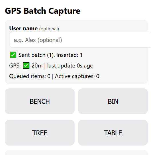
I went for a walk, today, to geo locate some benches.
Happy New Year!
I went for a walk, today, to geo locate some benches.
Some Retro Diary Entries
1st January 2026 Happy New Year! I went for a walk, today, to geo locate some benches.OpenStreetMap

এই ডায়েরি এন্ট্রিতে বাগমারা উপজেলার কাতিলা এলাকায় অবস্থিত নাগা বাজারের নিকটে অবস্থানরত নিছু কাতিলা গোবিন্দ মন্দিরের তথ্য সংযোজন করা হয়েছে। স্থানীয় হিন্দু সম্প্রদায়ের জন্য এটি একটি গুরুত্বপূর্ণ পূজাস্থল। ম্যাপে এই মন্দিরের অবস্থান চিহ্নিত করার মাধ্যমে নাগা বাজার ও আশপাশের এলাকা সম্পর্কিত ভৌগোলিক তথ্য আরও নির্ভুল হয়েছে এবং স্থানীয় সম্প্রদায়ের সাংস্কৃতিক ও ধর্মীয় দিকের প্রতিনিধিত্ব নিশ্চিত হয়।
নাগা বাজারের নিকটে নিছু কাতিলা গোবিন্দ মন্দিরের ম্যাপিং
এই ডায়েরি এন্ট্রিতে বাগমারা উপজেলার কাতিলা এলাকায় অবস্থিত নাগা বাজারের নিকটে অবস্থানরত নিছু কাতিলা গোবিন্দ মন্দিরের তথ্য সংযোজন করা হয়েছে। স্থানীয় হিন্দু সম্প্রদায়ের জন্য এটি একটি গুরুত্বপূর্ণ পূজাস্থল। ম্যাপে এই মন্দিরের অবস্থান চিহ্নিত করার মাধ্যমে…OpenStreetMap
এই ডায়েরি এন্ট্রিতে বাগমারা উপজেলার কাতিলা এলাকায় অবস্থিত নাগা বাজারের পশ্চিম পাশে মণ্ডল হাউসের অবস্থান ম্যাপে যুক্ত করার তথ্য তুলে ধরা হয়েছে। স্থানীয় বাসিন্দাদের বসতবাড়ি হিসেবে পরিচিত এই বাড়িটি নাগা বাজারের নিকটবর্তী হওয়ায় এলাকার ভৌগোলিক তথ্য আরও নির্ভুল ও হালনাগাদ হয়েছে। এই সংযোজনের মাধ্যমে নাগা বাজার সংলগ্ন আবাসিক এলাকার ম্যাপিং উন্নত হবে এবং ভবিষ্যতে স্থানীয় সেবা ও নেভিগেশনে সহায়ক ভূমিকা রাখবে।
নাগা বাজারের নিকটে মণ্ডল হাউস ম্যাপে সংযোজন
এই ডায়েরি এন্ট্রিতে বাগমারা উপজেলার কাতিলা এলাকায় অবস্থিত নাগা বাজারের পশ্চিম পাশে মণ্ডল হাউসের অবস্থান ম্যাপে যুক্ত করার তথ্য তুলে ধরা হয়েছে। স্থানীয় বাসিন্দাদের বসতবাড়ি হিসেবে পরিচিত এই বাড়িটি নাগা বাজারের নিকটবর্তী হওয়ায় এলাকার ভৌগোলিক তথ্য আরও নি…OpenStreetMap
[Ex-YU] Naški
##Postavimo Banju Luku na (digitalnu) kartu – Pridružite se #FOSMBL
Da li ste se ikada zapitali kako možemo najbolje iskoristiti potencijal našeg regiona? Sve počinje sa podacima. Pod hashtagom #FOSMBL (Friends of OpenStreetMap Banja Luka) želimo da sve izmjene na OpenStreetMap-u u Banjoj Luci i okolini učinimo vidljivijim i lakšim za pronalaženje.
Zašto #FOSMBL? Korištenjem ovog hashtaga u komentarima vaših izmjena (changesets), pomažete u stvaranju lokalne zajednice. To nam omogućava da pratimo napredak i bolje se koordinišemo. Ali cilj je mnogo veći od samog mapiranja:
Turizam: Ažurne karte pomažu turistima da pronađu naše znamenitosti, ugostiteljske objekte i staze.
Ekonomija: Precizni podaci su ključni za logistiku, lokalne biznise i ekonomski razvoj.
Vizija: Vrijeme je da razmislimo o formiranju zvanične OSM grupe za Banju Luku i regiju. Zajedno možemo organizovati “mapatone” i unaprijediti kvalitet podataka na viši nivo.
Hajde da zajedno pokrenemo Banju Luku u digitalnom svijetu!
[DE] Deutsch
##Banja Luka sichtbarer machen – Ein Aufruf an alle Mapper
Hast du dich jemals gefragt, wie wir das volle Potenzial unserer Region ausschöpfen können? Alles beginnt mit Daten. Unter dem Hashtag #FOSMBL (Friends of OpenStreetMap Banja Luka) wollen wir ab sofort alle Änderungen in OpenStreetMap in und um Banja Luka bündeln.
Warum #FOSMBL? Indem wir diesen Hashtag in unseren Changeset-Kommentaren verwenden, machen wir unsere Arbeit sichtbar. Es hilft uns zu sehen, wer woran arbeitet, und Fortschritte gemeinsam zu feiern. Aber es geht um mehr als nur Linien auf einer Karte:
Tourismus: Aktuelle Karten helfen Gästen, unsere Sehenswürdigkeiten, Cafés und Wanderwege zu finden.
Wirtschaft: Eine präzise Infrastruktur ist die Basis für Logistik und lokale Unternehmen.
Gemeinschaft: Es ist an der Zeit, über die Gründung einer festen OSM-Gruppe für Banja Luka und Umgebung nachzudenken. Gemeinsam können wir Mapping-Events (Mapathons) organisieren und die Qualität unserer Daten auf ein neues Level heben.
Lass uns Banja Luka gemeinsam digital vorantreiben!
[EN] English
##Putting Banja Luka on the (Digital) Map – Join #FOSMBL
Have you ever wondered how we can unlock the full potential of our region? It all starts with data. Under the hashtag #FOSMBL (Friends of OpenStreetMap Banja Luka), we want to make all changes in and around Banja Luka more visible and searchable.
Why use #FOSMBL? By adding this hashtag to your changeset comments, you help build a local community. It allows us to track progress and coordinate better. But the impact goes far beyond the screen:
Tourism: Up-to-date maps help tourists discover our landmarks, restaurants, and hidden gems.
Economy: Accurate geospatial data is a backbone for local businesses and regional development.
Vision: We are considering forming a dedicated OSM User Group for Banja Luka and the region. A formal group would allow us to organize mapathons and advocate for open data.
Let’s map the future of Banja Luka together!
#FOSMBL: Banja Luka auf die (digitale) Karte setzen!
##Postavimo Banju Luku na (digitalnu) kartu – Pridružite se #FOSMBLOpenStreetMap
Mir ist aufgefallen, daß die Überwachungskameras, die an jeder U-Bahn-Station im Raum Nürnberg-Fürth hängen, in OSM kaum verzeichnet sind. Ich habe daher angefangen, alle, die mir beim Warten auf die U-Bahn auffallen, einzuzeichnen. Dafür verwende ich Vespucci am Handy mit folgenden Tagsets:
man-made:surveillance
surveillance:public
surveillance-type:camera
surveillance-zone:public_transport_platform
camera-type:#ist entweder fixed oder dome
camera-mount:#ist entweder wall oder ceiling
camera-direction:#oft nur geschätzte Richtwerte
camera-angle:#ich versuche, mit der Android-App Clinometer möglichst akkurate Schätzwerte zum Neigungswinkel zu bekommen, funktioniert bisher erstaunlich gut
height:#nur Schätzungen
level:#selbsterklärend
operator:VAG Verkehrs-Aktiengesellschaft Nürnberg
operator-type:public
operator-wikidata:Q1557682
ref:#jede gerichtete VAG-Kamera hat an der Seite ein gelbes Schild, auf dem eine alphanumerische Referenznummer aufgedruckt ist, nach dem Schema 'VAG-NR. ###', wobei # jeweils eine Ziffer darstellt.
Die Referenznummern scheinen keinem bestimmten Schema zu folgen, jedenfalls nicht, soweit ich das nachvollziehen kann. Außerdem scheinen die dome-type Kameras kein Schild mit einer Referenznummer zu haben.
Wenn ihr Fragen oder Anregungen zu dem Thema habt, schreibt mir gerne, dann können wir ins Gespräch kommen. Fröhliches Kartographieren mittens_unofficial
man-made:surveillance
surveillance:public
surveillance-type:camera
surveillance-zone:public_transport_platform
camera-type:#ist entweder fixed oder dome
camera-mount:#ist entweder wall oder ceiling
camera-direction:#oft nur geschätzte Richtwerte
camera-angle:#ich versuche, mit der Android-App Clinometer möglichst akkurate Schätzwerte zum Neigungswinkel zu bekommen, funktioniert bisher erstaunlich gut
height:#nur Schätzungen
level:#selbsterklärend
operator:VAG Verkehrs-Aktiengesellschaft Nürnberg
operator-type:public
operator-wikidata:Q1557682
ref:#jede gerichtete VAG-Kamera hat an der Seite ein gelbes Schild, auf dem eine alphanumerische Referenznummer aufgedruckt ist, nach dem Schema 'VAG-NR. ###', wobei # jeweils eine Ziffer darstellt.
Die Referenznummern scheinen keinem bestimmten Schema zu folgen, jedenfalls nicht, soweit ich das nachvollziehen kann. Außerdem scheinen die dome-type Kameras kein Schild mit einer Referenznummer zu haben.
Wenn ihr Fragen oder Anregungen zu dem Thema habt, schreibt mir gerne, dann können wir ins Gespräch kommen. Fröhliches Kartographieren mittens_unofficial
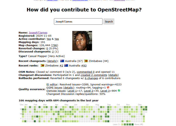
I wanted to know how well I was performing as an armchair mapper, internally I was concerned that I was creating more issues than I was helping so I learned about a website that answers the question How did I contribute?.
রাজশাহীর বাগমারা উপজেলার কাতিলা এলাকায় নাগা বাজারের নিকটে অবস্থিত একটি হিন্দু মন্দির OpenStreetMap-এ যুক্ত করা হয়েছে। মন্দিরটি স্থানীয় হিন্দু সম্প্রদায়ের একটি গুরুত্বপূর্ণ উপাসনালয় এবং নাগা বাজারসহ আশপাশের এলাকার মানুষ নিয়মিত এখানে পূজা–অর্চনা করে। এই সংযোজনের মাধ্যমে এলাকার ধর্মীয় স্থানের তথ্য আরও নির্ভুল ও দৃশ্যমান হলো।
নাগা বাজার, কাতিলা, বাগমারা, রাজশাহীতে হিন্দু মন্দির যুক্ত
রাজশাহীর বাগমারা উপজেলার কাতিলা এলাকায় নাগা বাজারের নিকটে অবস্থিত একটি হিন্দু মন্দির OpenStreetMap-এ যুক্ত করা হয়েছে। মন্দিরটি স্থানীয় হিন্দু সম্প্রদায়ের একটি গুরুত্বপূর্ণ উপাসনালয় এবং নাগা বাজারসহ আশপাশের এলাকার মানুষ নিয়মিত এখানে পূজা–অর্চনা করে। …OpenStreetMap
I dont know, can you? is a joke of mediocre quality that is supposed to point out the difference between being able to do something and being allowed to do something.
First and foremost, I want to express my sincere gratitude to the ESA Hub organization for selecting me for this fellowship. It was an honor to be chosen, and I am thankful for the opportunity to learn and contribute.
My experience in the 2025 Validator Fellowship for Eastern and Southern Africa began on November 3rd, 2025, and concluded on January 7th, 2026, with all sessions held remotely.
OpenStreetMap steht an einem kritischen Wendepunkt. Während die globale Community die Vorbereitungen für die State of the Map Konferenz in Paris (28.–30.
OpenStreetMap is a map of the world, created by people like you and free to use under an open license.
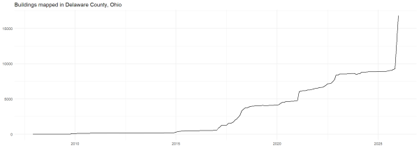
Over 7000 buildings in Delaware County in two months
Martina Neumayer
•